Seceda · Val Gardena · Panorama

Provider panorama/video player. Capture time is shown by the camera.
Open camera page ↗
Each colour starts at the value shown. Wind colours match across all three units. Dry cells stay neutral. Colours describe the displayed values, not official weather warnings.
Preparing forecast graphs…
Times and values match the detailed forecast. Tap or point at a value for details. Scroll each chart sideways for later days. Rain / precipitation is the total water equivalent per forecast interval, including snow; snowfall is fresh snow per interval, not snow depth.
GFS and ECMWF model comparison. Each model retains its own forecast times and horizon. Precipitation and snowfall amounts cover their own forecast intervals; these can differ between models.
ECMWF · Model run: Next update expected:
Day Time (UTC) Temp. (°C) Humidity (%) Wind (km/h) Wind (knots) Wind (Bft) Direction Precip. (mm) Snow (cm) Pressure (hPa) Freezing (m) Conditions | Thursday, 05/11 06:00 0.3 76 1 1 1B E — — 1029 < 1691 Clear 14% cloud  09:00 6.5 54 1 1 0B SW 0 0 1028 2753 Clear 0% cloud 12:00 9.6 46 2 1 1B W 0 0 1026 2884 Clear 0% cloud 15:00 7.4 60 2 1 1B SW 0 0 1025 2838 Clear 0% cloud 18:00 3.3 69 0 0 0B SE 0 0 1026 2472 Clear 0% cloud 21:00 2.6 68 0 0 0B E 0 0 1025 2257 Clear 0% cloud Friday, 06/11 00:00 2.4 66 0 0 0B E 0 0 1024 < 1691 Clear 0% cloud 03:00 2.5 61 0 0 0B E 0 0 1023 1903 Clear 0% cloud 06:00 2.7 58 0 0 0B E 0 0 1022 2260 Clear 1% cloud 09:00 8.6 41 1 1 0B S 0 0 1022 2995 Cloudy 68% cloud  12:00 10.8 37 2 1 1B SW 0 0 1020 2925 Cloudy 78% cloud 15:00 7.3 55 2 1 1B SW 0 0 1020 2613 Overcast 95% cloud  18:00 4.7 66 2 1 1B S 0 0 1021 2227 Overcast 100% cloud 21:00 4.1 75 0 0 0B S 0.43 0 1023 2031 Overcast 100% cloud Saturday, 07/11 00:00 3.6 79 1 1 1B E 0.45 0 1023 1920 Overcast 99% cloud 03:00 3.4 78 1 0 0B NE 0.35 0 1023 1860 Overcast 99% cloud 06:00 3.2 78 1 1 1B E 0.61 0 1024 1826 Overcast 97% cloud 09:00 5.2 72 2 1 1B E 0.13 0 1025 2090 Overcast 98% cloud 12:00 6.9 60 1 1 0B E 0.05 0 1023 2274 Overcast 93% cloud 15:00 6.2 62 2 1 1B S 0.20 0 1023 2200 Overcast 84% cloud 18:00 3.6 71 1 0 0B SE 0.03 0 1025 1901 Cloudy 65% cloud 21:00 2.3 72 0 0 0B E 0.03 0 1026 < 1691 Partly cloudy 39% cloud  Sunday, 08/11 00:00 1.6 70 0 0 0B E 0.03 0 1026 < 1691 Partly cloudy 33% cloud 03:00 1.1 69 0 0 0B E 0 0 1025 < 1691 Partly cloudy 33% cloud 06:00 0.8 69 0 0 0B NE 0.03 0 1026 < 1691 Partly cloudy 31% cloud 09:00 5.3 56 2 1 1B SW 0.03 0 1026 2102 Partly cloudy 31% cloud 12:00 7.6 48 5 3 1B SW 0 0 1024 2260 Partly cloudy 45% cloud 15:00 5.5 64 3 2 1B W 0 0 1024 2096 Partly cloudy 41% cloud 18:00 1.9 78 1 0 0B SE 0 0 1025 < 1691 Clear 15% cloud 21:00 -0.1 82 1 0 0B SE 0 0 1026 < 1691 Cloudy 55% cloud Monday, 09/11 00:00 -1.3 83 1 0 0B E 0 0 1026 < 1691 Cloudy 75% cloud 03:00 -1.4 82 1 0 0B E 0 0 1025 < 1691 Partly cloudy 47% cloud 06:00 -1 81 1 0 0B E 0 0 1025 < 1691 Cloudy 77% cloud 09:00 5 56 3 2 1B SW 0 0 1025 2205 Cloudy 79% cloud 12:00 6.8 56 4 2 1B SW 0 0 1022 2457 Cloudy 65% cloud 15:00 4.6 71 4 2 1B SW 0 0 1021 2263 Overcast 89% cloud 18:00 2 79 2 1 1B S 0 0 1022 < 1691 Cloudy 76% cloud 21:00 1.9 81 2 1 1B S 0.02 0 1021 < 1691 Overcast 88% cloud Tuesday, 10/11 00:00 1.3 83 2 1 1B S 0.06 0 1021 < 1691 Overcast 97% cloud 03:00 2 84 2 1 1B S 0 0 1019 < 1691 Overcast 100% cloud 06:00 2.5 84 2 1 1B SE 0 0 1018 < 1691 Overcast 100% cloud 09:00 5.4 76 2 1 1B SW 0.08 0 1018 2642 Overcast 91% cloud 12:00 8.1 64 4 2 1B SW 0.05 0 1015 2821 Overcast 99% cloud 15:00 6 79 1 0 0B W 0.09 0 1015 2776 Overcast 97% cloud 18:00 3.7 82 1 0 0B NE 0.14 0 1015 2501 Partly cloudy 41% cloud 21:00 3.5 80 1 1 1B E 0.05 0 1015 2371 Cloudy 55% cloud Wednesday, 11/11 00:00 3.4 78 1 0 0B E 0 0 1015 2226 Cloudy 52% cloud 03:00 3.9 74 1 0 0B E 0 0 1014 2444 Clear 16% cloud 06:00 3.9 73 0 0 0B SE 0 0 1015 2505 Clear 2% cloud |
|---|
Forecast table times: UTC.
Coordinates: 46.57219672°N, 11.6709137°E · Requested elevation: 1235 m. Model terrain: 1689 m. Terrain and 1000/925/850/700 hPa profiles are used for height estimates.
Outside the available profile, temperature uses an estimated 5.5°C/km height correction; wind retains the nearest available model-level value. Humidity is estimated with adjusted pressure and temperature.
These are altitude estimates, not a simulation of local mountain terrain. Precipitation, cloud and sea-level pressure use horizontal interpolation only.
Precipitation includes rain and snow water equivalent: preceding 3 hours through day 6, then 6 hours (see cell tooltip). Snow (cm) estimates fresh snowfall from precipitation and temperature using the GFS conversion; it is not snow depth on the ground. Freezing (m) uses additional 600/500 hPa temperatures when available and estimates the lowest resolved 0°C crossing above sea level. When all sampled levels are warm, the upper profile limit is shown (see tooltip). < marks an entirely cold sampled profile and its lower height limit. No extrapolation is used.
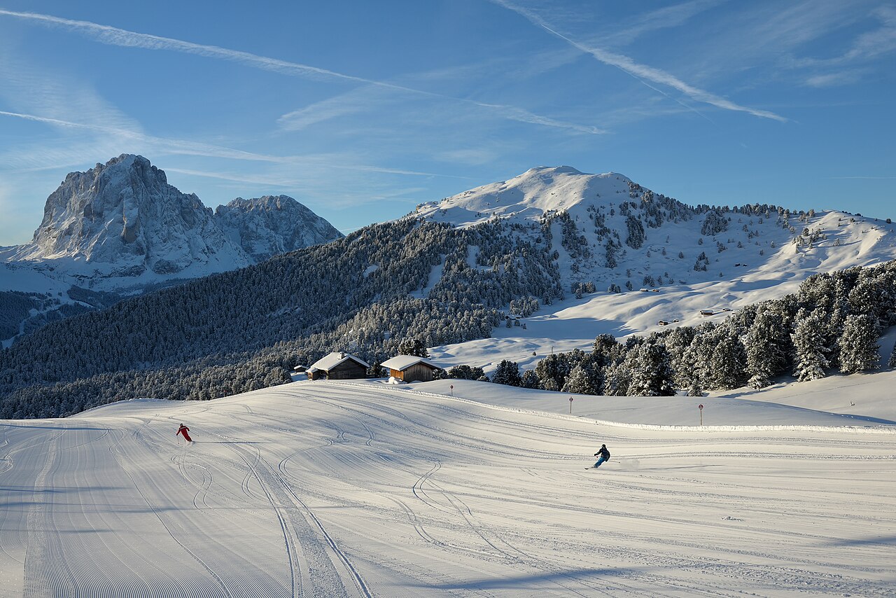
Val Gardena offers several different starting points for a Dolomites ski day. Ortisei gives access to Seceda and Alpe di Siusi, while Santa Cristina and Selva lead into other parts of the valley’s network. From Seceda, La Longia is a long red descent back to Ortisei; it should not be confused with the Sellaronda circuit around the Sella massif.
The official itinerary descriptions are particularly useful here because not every tour is simply a chain of ski lifts and pistes. The Val Gardena Ronda includes a ski-bus transfer between Saltria and Monte Pana. Before choosing a full-day circuit, check its transport sections and return options as well as its distance. The live report lists the two Sellaronda directions separately.
Our selected point is at 1,235 m, close to the elevation of Ortisei rather than the upper ski terrain. Use a higher point for a day around Seceda, and keep the lower forecast for the return. The temperature change between morning and afternoon can matter over a long descent. Snowfall predicted at one height should not be applied unchanged to every part of the valley.
Official sources: Val Gardena ski itineraries · Seceda — winter · Val Gardena open slopes. Reviewed 18 October 2026.
Provider panorama/video player. Capture time is shown by the camera.
Open camera page ↗Preparing forecast graphs…
Times and values match the detailed forecast. Tap or point at a value for details. Scroll each chart sideways for later days. Rain / precipitation is the total water equivalent per forecast interval, including snow; snowfall is fresh snow per interval, not snow depth.
GFS and ECMWF model comparison. Each model retains its own forecast times and horizon. Precipitation and snowfall amounts cover their own forecast intervals; these can differ between models.
ECMWF · Model run: Next update expected:
Day Time (UTC) Temp. (°C) Humidity (%) Wind (km/h) Wind (knots) Wind (Bft) Direction Precip. (mm) Snow (cm) Pressure (hPa) Freezing (m) Conditions | Thursday, 05/11 06:00 -2.1 78 2 1 1B S — — 1028 < 1696 Clear 13% cloud 09:00 3.3 57 3 2 1B SW 0 0 1028 2759 Clear 0% cloud 12:00 6 51 3 2 1B SW 0 0 1026 2883 Clear 0% cloud 15:00 4.1 65 3 2 1B SW 0 0 1025 2834 Clear 0% cloud 18:00 0.6 72 2 1 1B S 0 0 1026 2456 Clear 0% cloud 21:00 0.1 71 1 1 1B S 0 0 1025 2282 Clear 0% cloud Friday, 06/11 00:00 -0.1 68 2 1 1B S 0 0 1024 < 1696 Clear 0% cloud 03:00 0.1 63 1 1 1B S 0 0 1023 2146 Clear 0% cloud 06:00 0.2 60 1 1 1B SE 0 0 1022 2370 Clear 1% cloud 09:00 5.3 44 3 2 1B S 0 0 1022 2995 Cloudy 70% cloud 12:00 7 42 5 2 1B S 0 0 1020 2923 Overcast 80% cloud 15:00 3.8 61 4 2 1B S 0 0 1020 2606 Overcast 95% cloud 18:00 1.5 72 5 3 1B SE 0 0 1021 2228 Overcast 100% cloud 21:00 0.7 83 5 3 1B SE 0.45 0.1 1023 2034 Overcast 100% cloud Saturday, 07/11 00:00 0.2 88 5 3 1B SE 0.46 0.1 1023 1923 Overcast 99% cloud 03:00 -0.1 89 4 2 1B SE 0.36 0.1 1023 1861 Overcast 100% cloud 06:00 -0.3 90 4 2 1B SE 0.65 0.2 1024 1825 Overcast 97% cloud 09:00 1.4 83 3 1 1B E 0.13 0 1025 2091 Overcast 97% cloud 12:00 3 72 3 2 1B SE 0.05 0 1023 2270 Overcast 94% cloud 15:00 2.3 72 4 2 1B SE 0.22 0 1023 2193 Overcast 86% cloud 18:00 0.1 82 3 2 1B SE 0.03 0 1025 1898 Cloudy 67% cloud 21:00 -0.9 81 2 1 1B SE 0.03 0 1026 < 1696 Partly cloudy 42% cloud Sunday, 08/11 00:00 -1.5 79 2 1 1B SE 0.03 0 1026 < 1696 Partly cloudy 35% cloud 03:00 -2 78 2 1 1B SE 0 0 1025 < 1696 Partly cloudy 35% cloud 06:00 -2.2 78 1 0 0B SE 0.03 0 1026 < 1696 Partly cloudy 33% cloud 09:00 1.5 66 2 1 1B SW 0.03 0 1026 2098 Partly cloudy 34% cloud 12:00 3.4 58 5 3 1B SW 0 0 1024 2257 Partly cloudy 45% cloud 15:00 1.6 74 4 2 1B W 0 0 1024 2093 Partly cloudy 42% cloud 18:00 -1.5 87 1 0 0B W 0 0 1025 < 1696 Clear 15% cloud 21:00 -3.1 90 1 0 0B NW 0 0 1026 < 1696 Cloudy 57% cloud Monday, 09/11 00:00 -4.1 89 1 0 0B NW 0 0 1026 < 1696 Cloudy 77% cloud 03:00 -4.1 88 1 1 0B W 0 0 1025 < 1696 Partly cloudy 47% cloud 06:00 -3.7 86 1 1 1B W 0 0 1025 < 1696 Cloudy 78% cloud 09:00 1.6 62 5 2 1B SW 0 0 1025 2208 Cloudy 79% cloud 12:00 3.3 62 7 4 2B SW 0 0 1022 2455 Cloudy 65% cloud 15:00 1.4 78 7 4 2B SW 0 0 1021 2262 Overcast 89% cloud 18:00 -0.8 87 5 3 1B SW 0 0 1022 < 1696 Cloudy 75% cloud 21:00 -0.9 90 5 3 1B SW 0.02 0 1021 < 1696 Overcast 87% cloud Tuesday, 10/11 00:00 -1.4 92 4 2 1B SW 0.06 0 1021 < 1696 Overcast 97% cloud 03:00 -0.7 93 4 2 1B SW 0 0 1019 < 1696 Overcast 100% cloud 06:00 -0.2 93 3 2 1B W 0 0 1018 1696 Overcast 100% cloud 09:00 2.4 85 5 3 1B W 0.08 0 1018 2651 Overcast 90% cloud 12:00 4.7 74 7 4 2B W 0.04 0 1015 2823 Overcast 99% cloud 15:00 2.9 88 4 2 1B W 0.08 0 1015 2782 Overcast 97% cloud 18:00 0.9 92 3 2 1B NW 0.14 0 1015 2503 Partly cloudy 41% cloud 21:00 0.7 89 2 1 1B N 0.04 0 1015 2366 Cloudy 54% cloud Wednesday, 11/11 00:00 0.6 87 1 1 1B N 0 0 1015 2231 Cloudy 51% cloud 03:00 1.1 82 1 0 0B W 0 0 1014 2463 Clear 17% cloud 06:00 1.2 81 1 1 1B W 0 0 1015 2527 Clear 2% cloud |
|---|
Forecast table times: UTC.
Coordinates: 46.55956851°N, 11.66524887°E · Requested elevation: 1874 m. Model terrain: 1693 m. Terrain and 1000/925/850/700 hPa profiles are used for height estimates.
These are altitude estimates, not a simulation of local mountain terrain. Precipitation, cloud and sea-level pressure use horizontal interpolation only.
Precipitation includes rain and snow water equivalent: preceding 3 hours through day 6, then 6 hours (see cell tooltip). Snow (cm) estimates fresh snowfall from precipitation and temperature using the GFS conversion; it is not snow depth on the ground. Freezing (m) uses additional 600/500 hPa temperatures when available and estimates the lowest resolved 0°C crossing above sea level. When all sampled levels are warm, the upper profile limit is shown (see tooltip). < marks an entirely cold sampled profile and its lower height limit. No extrapolation is used.
Preparing forecast graphs…
Times and values match the detailed forecast. Tap or point at a value for details. Scroll each chart sideways for later days. Rain / precipitation is the total water equivalent per forecast interval, including snow; snowfall is fresh snow per interval, not snow depth.
GFS and ECMWF model comparison. Each model retains its own forecast times and horizon. Precipitation and snowfall amounts cover their own forecast intervals; these can differ between models.
ECMWF · Model run: Next update expected:
Day Time (UTC) Temp. (°C) Humidity (%) Wind (km/h) Wind (knots) Wind (Bft) Direction Precip. (mm) Snow (cm) Pressure (hPa) Freezing (m) Conditions | Thursday, 05/11 06:00 -1.9 48 13 7 3B S — — 1028 < 1493 Clear 8% cloud 09:00 0.9 42 13 7 3B SW 0 0 1028 2764 Clear 0% cloud 12:00 1.9 44 11 6 2B SW 0 0 1026 2863 Clear 0% cloud 15:00 1.2 50 10 5 2B SW 0 0 1026 2815 Clear 0% cloud 18:00 0 51 9 5 2B SW 0 0 1026 2541 Clear 0% cloud 21:00 0 49 7 4 2B S 0 0 1026 2580 Clear 0% cloud Friday, 06/11 00:00 0 48 9 5 2B S 0 0 1025 2548 Clear 0% cloud 03:00 0.1 45 8 4 2B S 0 0 1024 2651 Clear 1% cloud 06:00 0 43 7 4 2B S 0 0 1023 2525 Clear 2% cloud 09:00 2 40 12 6 2B S 0 0 1022 2971 Cloudy 69% cloud 12:00 2.2 40 16 8 3B S 0 0 1020 2897 Overcast 89% cloud 15:00 0.2 53 16 9 3B SE 0 0 1021 2561 Overcast 95% cloud 18:00 -1.1 62 21 11 4B SE 0 0 1022 2260 Overcast 100% cloud 21:00 -2.3 74 24 13 4B SE 0.56 0.2 1023 2038 Overcast 100% cloud Saturday, 07/11 00:00 -3.1 84 23 13 4B SE 0.55 0.5 1024 1885 Overcast 100% cloud 03:00 -3.7 93 19 10 3B SE 0.44 0.4 1023 1819 Overcast 100% cloud 06:00 -3.9 95 12 6 2B SE 0.98 1 1024 1760 Overcast 97% cloud 09:00 -3.1 94 6 3 2B SE 0.07 0.1 1025 2045 Overcast 95% cloud 12:00 -2.1 89 12 6 2B SE 0.08 0 1023 2230 Overcast 98% cloud 15:00 -2.6 87 11 6 2B SE 0.44 0.1 1024 2137 Overcast 91% cloud 18:00 -3.5 92 11 6 2B SE 0.08 0.1 1025 1879 Cloudy 78% cloud 21:00 -3.6 83 12 6 2B SE 0.08 0.1 1026 1798 Cloudy 74% cloud Sunday, 08/11 00:00 -4.1 84 9 5 2B SE 0.08 0.1 1026 1615 Cloudy 71% cloud 03:00 -4.1 82 6 3 2B SE 0 0 1025 < 1493 Cloudy 71% cloud 06:00 -4.4 83 3 2 1B S 0.08 0.1 1026 < 1493 Cloudy 61% cloud 09:00 -3.3 80 4 2 1B S 0.08 0.1 1027 2004 Cloudy 71% cloud 12:00 -2.7 77 8 4 2B SW 0 0 1024 2196 Partly cloudy 41% cloud 15:00 -3.2 78 6 3 2B SW 0 0 1024 2072 Partly cloudy 32% cloud 18:00 -4.2 80 7 4 2B NW 0 0 1025 1578 Clear 17% cloud 21:00 -4.7 75 7 4 2B NW 0 0 1026 < 1493 Cloudy 66% cloud Monday, 09/11 00:00 -4.8 70 7 4 2B NW 0 0 1026 < 1493 Overcast 82% cloud 03:00 -4.7 64 9 5 2B W 0 0 1025 < 1493 Cloudy 59% cloud 06:00 -4.1 62 9 5 2B W 0 0 1025 < 1493 Overcast 86% cloud 09:00 -1.5 55 11 6 2B SW 0 0 1025 2198 Overcast 83% cloud 12:00 -0.4 57 18 10 3B SW 0 0 1023 2442 Cloudy 72% cloud 15:00 -0.7 66 21 11 4B SW 0 0 1022 2345 Overcast 88% cloud 18:00 -1.4 74 22 12 4B SW 0 0 1022 1844 Cloudy 78% cloud 21:00 -1.3 79 22 12 4B W 0.01 0 1022 1685 Overcast 84% cloud Tuesday, 10/11 00:00 -1.5 83 21 11 4B W 0.04 0 1021 < 1493 Overcast 96% cloud 03:00 -0.9 84 21 11 4B W 0 0 1019 1857 Overcast 99% cloud 06:00 -0.5 84 19 11 3B W 0 0 1018 2184 Overcast 100% cloud 09:00 0.6 81 19 10 3B W 0.17 0 1018 2691 Overcast 89% cloud 12:00 1.4 79 18 10 3B W 0.00 0 1016 2824 Overcast 100% cloud 15:00 1.1 86 17 9 3B W 0.02 0 1015 2830 Overcast 98% cloud 18:00 0.2 86 15 8 3B NW 0.08 0 1015 2638 Partly cloudy 45% cloud 21:00 -0.2 83 12 6 2B NW 0.00 0 1015 2357 Partly cloudy 45% cloud Wednesday, 11/11 00:00 -0.5 84 7 4 2B NW 0 0 1015 2128 Partly cloudy 49% cloud 03:00 -0 77 6 3 2B W 0 0 1014 2491 Partly cloudy 22% cloud 06:00 0.1 75 8 4 2B W 0 0 1015 2579 Clear 0% cloud |
|---|
Forecast table times: UTC.
Coordinates: 46.51091656°N, 11.57546997°E · Requested elevation: 2518 m. Model terrain: 1490 m. Terrain and 1000/925/850/700 hPa profiles are used for height estimates.
These are altitude estimates, not a simulation of local mountain terrain. Precipitation, cloud and sea-level pressure use horizontal interpolation only.
Precipitation includes rain and snow water equivalent: preceding 3 hours through day 6, then 6 hours (see cell tooltip). Snow (cm) estimates fresh snowfall from precipitation and temperature using the GFS conversion; it is not snow depth on the ground. Freezing (m) uses additional 600/500 hPa temperatures when available and estimates the lowest resolved 0°C crossing above sea level. When all sampled levels are warm, the upper profile limit is shown (see tooltip). < marks an entirely cold sampled profile and its lower height limit. No extrapolation is used.