Faloria · Cortina · Panorama

Provider panorama/video player. Capture time is shown by the camera.
Open camera page ↗
Each colour starts at the value shown. Wind colours match across all three units. Dry cells stay neutral. Colours describe the displayed values, not official weather warnings.
Preparing forecast graphs…
Times and values match the detailed forecast. Tap or point at a value for details. Scroll each chart sideways for later days. Rain / precipitation is the total water equivalent per forecast interval, including snow; snowfall is fresh snow per interval, not snow depth.
GFS and ECMWF model comparison. Each model retains its own forecast times and horizon. Precipitation and snowfall amounts cover their own forecast intervals; these can differ between models.
ECMWF · Model run: Next update expected:
Day Time (UTC) Temp. (°C) Humidity (%) Wind (km/h) Wind (knots) Wind (Bft) Direction Precip. (mm) Snow (cm) Pressure (hPa) Freezing (m) Conditions | Thursday, 05/11 06:00 -0.3 77 3 2 1B NW — — 1028 < 1800 Partly cloudy 33% cloud  09:00 7 54 2 1 1B SE 0 0 1028 2723 Clear 0% cloud  12:00 10.2 43 4 2 1B SE 0 0 1025 2918 Clear 0% cloud 15:00 7.7 60 3 2 1B S 0 0 1024 2894 Clear 0% cloud 18:00 3.1 70 1 1 1B NW 0 0 1025 < 1800 Clear 0% cloud 21:00 2.6 66 1 1 0B NW 0 0 1025 < 1800 Clear 0% cloud Friday, 06/11 00:00 2.7 62 2 1 1B N 0 0 1023 < 1800 Clear 0% cloud 03:00 2.8 57 1 1 1B NW 0 0 1022 < 1800 Clear 0% cloud 06:00 3.1 54 1 1 1B N 0 0 1021 < 1800 Clear 0% cloud 09:00 9.2 38 3 1 1B SE 0 0 1021 3009 Clear 12% cloud 12:00 11.1 34 5 3 1B SE 0 0 1020 2948 Partly cloudy 25% cloud 15:00 7.7 58 3 2 1B SE 0 0 1020 2702 Overcast 99% cloud  18:00 4.4 74 1 1 1B E 0 0 1022 2190 Overcast 98% cloud 21:00 3.7 80 1 1 1B N 0.05 0 1023 1950 Overcast 100% cloud Saturday, 07/11 00:00 3.6 81 1 1 1B NE 0.31 0 1023 1903 Overcast 100% cloud 03:00 3.5 79 2 1 1B NE 0.08 0 1023 1860 Overcast 100% cloud 06:00 3.3 81 2 1 1B NE 0.16 0 1024 1824 Overcast 100% cloud 09:00 4.5 73 2 1 1B E 0.44 0 1025 2023 Overcast 100% cloud 12:00 7 51 3 2 1B SE 0.12 0 1024 2314 Overcast 90% cloud 15:00 6 54 3 2 1B SE 0.05 0 1024 2203 Cloudy 72% cloud  18:00 2.9 64 1 0 0B NE 0 0 1025 < 1800 Partly cloudy 23% cloud 21:00 1.6 64 2 1 1B N 0 0 1026 < 1800 Partly cloudy 23% cloud Sunday, 08/11 00:00 1 59 1 1 1B N 0 0 1026 < 1800 Clear 13% cloud 03:00 1.4 48 1 0 0B N 0 0 1025 < 1800 Clear 19% cloud 06:00 1.5 42 1 0 0B N 0 0 1025 < 1800 Partly cloudy 34% cloud 09:00 6.3 32 3 2 1B SE 0 0 1025 2240 Clear 14% cloud 12:00 7.7 38 6 3 2B S 0 0 1024 2304 Partly cloudy 22% cloud 15:00 5.2 49 4 2 1B S 0 0 1024 2081 Partly cloudy 35% cloud 18:00 1.5 62 1 0 0B NW 0 0 1026 < 1800 Clear 13% cloud 21:00 -0.2 71 2 1 1B NW 0 0 1026 < 1800 Clear 8% cloud Monday, 09/11 00:00 -1.2 75 3 2 1B NW 0 0 1025 < 1800 Partly cloudy 34% cloud 03:00 -1.3 76 2 1 1B NW 0 0 1024 < 1800 Clear 12% cloud 06:00 -1.1 75 1 1 1B NW 0 0 1025 < 1800 Partly cloudy 41% cloud 09:00 5.8 52 4 2 1B S 0 0 1024 2289 Cloudy 71% cloud 12:00 7.3 52 6 3 1B S 0 0 1022 2490 Partly cloudy 45% cloud 15:00 4.3 69 4 2 1B S 0 0 1021 2173 Overcast 86% cloud 18:00 1.4 79 1 1 1B SW 0 0 1022 < 1800 Cloudy 71% cloud 21:00 1.3 79 2 1 1B W 0 0 1022 < 1800 Partly cloudy 49% cloud Tuesday, 10/11 00:00 0.7 83 3 2 1B NW 0.10 0 1021 < 1800 Overcast 85% cloud 03:00 1.5 82 3 2 1B NW 0 0 1019 < 1800 Overcast 92% cloud 06:00 2.5 81 3 2 1B NW 0 0 1018 < 1800 Overcast 99% cloud 09:00 6.6 67 2 1 1B W 0.04 0 1017 2851 Cloudy 73% cloud 12:00 9.5 59 5 3 1B SW 0 0 1013 2952 Overcast 99% cloud 15:00 6 77 1 0 0B NW 0.21 0 1014 2836 Overcast 99% cloud 18:00 4.1 78 3 2 1B NW 0.04 0 1014 2600 Cloudy 62% cloud 21:00 3.9 77 3 2 1B NW 0 0 1014 2332 Cloudy 64% cloud Wednesday, 11/11 00:00 3.7 76 1 1 1B NW 0 0 1014 2181 Cloudy 68% cloud 03:00 3.6 76 1 1 1B N 0 0 1014 2171 Partly cloudy 34% cloud 06:00 3.3 78 1 1 0B N 0 0 1015 1936 Partly cloudy 46% cloud |
|---|
Forecast table times: UTC.
Coordinates: 46.537995°N, 12.1406781°E · Requested elevation: 1225 m. Model terrain: 1797 m. Terrain and 1000/925/850/700 hPa profiles are used for height estimates.
Outside the available profile, temperature uses an estimated 5.5°C/km height correction; wind retains the nearest available model-level value. Humidity is estimated with adjusted pressure and temperature.
These are altitude estimates, not a simulation of local mountain terrain. Precipitation, cloud and sea-level pressure use horizontal interpolation only.
Precipitation includes rain and snow water equivalent: preceding 3 hours through day 6, then 6 hours (see cell tooltip). Snow (cm) estimates fresh snowfall from precipitation and temperature using the GFS conversion; it is not snow depth on the ground. Freezing (m) uses additional 600/500 hPa temperatures when available and estimates the lowest resolved 0°C crossing above sea level. When all sampled levels are warm, the upper profile limit is shown (see tooltip). < marks an entirely cold sampled profile and its lower height limit. No extrapolation is used.
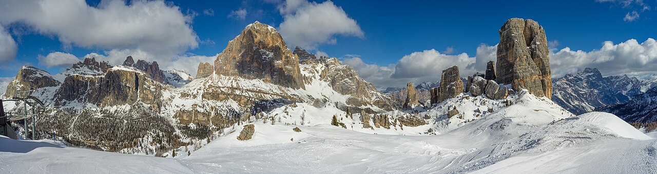
Cortina d’Ampezzo offers several ski sectors around the Ampezzo valley, rather than one compact mountain reached from a single lift. Faloria–Cristallo, Tofana and the 5 Torri–Lagazuoi area each provide a different starting point. The Cortina Skyline gondola links Son dei Prade with Bai de Dones, so a current piste map is useful even for returning visitors.
The forecast selector on this page distinguishes three named locations: the Faloria cable-car valley station at 1,225 m, the Faloria upper station at 2,123 m, and Ra Valles in the Tofana sector at 2,470 m. These are real reference points in different parts of Cortina, not three heights above a single coordinate. Choose the point closest to your intended skiing before comparing temperatures or snowfall.
If a camera shows snow while the lower forecast shows rain, check its position and elevation first. For a day involving several sectors, compare the timing of conditions at the destination and on the way back. The operator’s live lift information remains the source for actual access; neither a common ski pass nor a favourable forecast confirms that every connection is open.
Official sources: Cortina — skiing and snowboarding · Faloria · Tofana official map. Reviewed 18 October 2026.
Provider panorama/video player. Capture time is shown by the camera.
Open camera page ↗Preparing forecast graphs…
Times and values match the detailed forecast. Tap or point at a value for details. Scroll each chart sideways for later days. Rain / precipitation is the total water equivalent per forecast interval, including snow; snowfall is fresh snow per interval, not snow depth.
GFS and ECMWF model comparison. Each model retains its own forecast times and horizon. Precipitation and snowfall amounts cover their own forecast intervals; these can differ between models.
ECMWF · Model run: Next update expected:
Day Time (UTC) Temp. (°C) Humidity (%) Wind (km/h) Wind (knots) Wind (Bft) Direction Precip. (mm) Snow (cm) Pressure (hPa) Freezing (m) Conditions | Thursday, 05/11 06:00 -3.1 73 4 2 1B SW — — 1028 < 1774 Partly cloudy 39% cloud 09:00 2.5 55 5 2 1B S 0 0 1028 2716 Clear 0% cloud 12:00 5 46 6 3 2B S 0 0 1025 2920 Clear 0% cloud 15:00 3.2 60 4 2 1B S 0 0 1025 2902 Clear 0% cloud 18:00 -0.1 67 2 1 1B SW 0 0 1025 < 1774 Clear 0% cloud 21:00 -0.5 64 2 1 1B SW 0 0 1025 < 1774 Clear 0% cloud Friday, 06/11 00:00 -0.5 60 2 1 1B SW 0 0 1023 < 1774 Clear 0% cloud 03:00 -0.4 56 2 1 1B SW 0 0 1022 < 1774 Clear 0% cloud 06:00 -0.2 53 1 1 1B S 0 0 1021 < 1774 Clear 0% cloud 09:00 4.3 41 6 3 1B SE 0 0 1022 3005 Clear 9% cloud 12:00 5.7 39 9 5 2B S 0 0 1020 2950 Partly cloudy 21% cloud 15:00 3 61 8 5 2B S 0 0 1020 2714 Overcast 99% cloud 18:00 0.3 74 7 4 2B SE 0 0 1022 2207 Overcast 98% cloud 21:00 -0.7 82 7 4 2B SE 0.03 0 1023 1941 Overcast 100% cloud Saturday, 07/11 00:00 -1 89 10 5 2B SE 0.28 0.1 1023 1903 Overcast 100% cloud 03:00 -1.5 93 10 5 2B SE 0.09 0 1023 1847 Overcast 100% cloud 06:00 -1.6 96 8 4 2B SE 0.15 0 1024 1813 Overcast 100% cloud 09:00 -0.7 90 7 4 2B SE 0.45 0.1 1026 2003 Overcast 100% cloud 12:00 1.4 61 10 5 2B SE 0.12 0 1024 2320 Overcast 90% cloud 15:00 0.6 67 9 5 2B SE 0.03 0 1024 2206 Cloudy 70% cloud 18:00 -1.7 75 7 4 2B SE 0 0 1025 < 1774 Clear 18% cloud 21:00 -2.7 74 5 2 1B SE 0 0 1026 < 1774 Partly cloudy 23% cloud Sunday, 08/11 00:00 -3.1 71 5 3 1B SE 0 0 1026 < 1774 Clear 13% cloud 03:00 -2.7 58 5 3 1B SE 0 0 1025 < 1774 Partly cloudy 21% cloud 06:00 -2.8 56 4 2 1B S 0 0 1025 < 1774 Partly cloudy 39% cloud 09:00 0.8 42 6 3 2B S 0 0 1025 2241 Clear 15% cloud 12:00 1.6 50 7 4 2B S 0 0 1024 2300 Partly cloudy 24% cloud 15:00 -0.4 62 3 1 1B SW 0 0 1024 2075 Partly cloudy 29% cloud 18:00 -3.1 73 4 2 1B W 0 0 1026 < 1774 Clear 12% cloud 21:00 -4.1 79 4 2 1B NW 0 0 1026 < 1774 Clear 6% cloud Monday, 09/11 00:00 -4.7 78 5 3 1B NW 0 0 1025 < 1774 Partly cloudy 27% cloud 03:00 -4.7 76 5 3 1B NW 0 0 1024 < 1774 Clear 10% cloud 06:00 -4.4 76 5 3 1B W 0 0 1025 < 1774 Partly cloudy 38% cloud 09:00 0.8 58 6 3 1B SW 0 0 1024 2282 Cloudy 71% cloud 12:00 2.1 58 9 5 2B SW 0 0 1022 2484 Partly cloudy 44% cloud 15:00 0.1 74 10 6 2B SW 0 0 1021 2155 Overcast 86% cloud 18:00 -1.9 83 11 6 2B W 0 0 1023 < 1774 Cloudy 69% cloud 21:00 -1.7 84 12 7 3B W 0 0 1022 < 1774 Partly cloudy 45% cloud Tuesday, 10/11 00:00 -1.9 89 13 7 3B W 0.11 0 1021 < 1774 Overcast 82% cloud 03:00 -1.3 88 12 7 2B W 0 0 1019 < 1774 Overcast 91% cloud 06:00 -0.6 87 11 6 2B W 0 0 1018 < 1774 Overcast 99% cloud 09:00 2.5 76 10 5 2B W 0.03 0 1017 2871 Cloudy 73% cloud 12:00 4.5 70 10 5 2B W 0 0 1013 2962 Overcast 99% cloud 15:00 2 88 9 5 2B W 0.21 0 1014 2845 Overcast 99% cloud 18:00 0.7 88 8 4 2B NW 0.03 0 1014 2646 Cloudy 64% cloud 21:00 0.2 88 7 4 2B NW 0 0 1014 2300 Cloudy 63% cloud Wednesday, 11/11 00:00 -0.1 87 5 3 1B NW 0 0 1014 2046 Cloudy 70% cloud 03:00 -0.2 86 4 2 1B NW 0 0 1014 1960 Partly cloudy 38% cloud 06:00 -0.4 88 4 2 1B W 0 0 1015 < 1774 Cloudy 54% cloud |
|---|
Forecast table times: UTC.
Coordinates: 46.532618°N, 12.1726708°E · Requested elevation: 2123 m. Model terrain: 1772 m. Terrain and 1000/925/850/700 hPa profiles are used for height estimates.
These are altitude estimates, not a simulation of local mountain terrain. Precipitation, cloud and sea-level pressure use horizontal interpolation only.
Precipitation includes rain and snow water equivalent: preceding 3 hours through day 6, then 6 hours (see cell tooltip). Snow (cm) estimates fresh snowfall from precipitation and temperature using the GFS conversion; it is not snow depth on the ground. Freezing (m) uses additional 600/500 hPa temperatures when available and estimates the lowest resolved 0°C crossing above sea level. When all sampled levels are warm, the upper profile limit is shown (see tooltip). < marks an entirely cold sampled profile and its lower height limit. No extrapolation is used.
Preparing forecast graphs…
Times and values match the detailed forecast. Tap or point at a value for details. Scroll each chart sideways for later days. Rain / precipitation is the total water equivalent per forecast interval, including snow; snowfall is fresh snow per interval, not snow depth.
GFS and ECMWF model comparison. Each model retains its own forecast times and horizon. Precipitation and snowfall amounts cover their own forecast intervals; these can differ between models.
ECMWF · Model run: Next update expected:
Day Time (UTC) Temp. (°C) Humidity (%) Wind (km/h) Wind (knots) Wind (Bft) Direction Precip. (mm) Snow (cm) Pressure (hPa) Freezing (m) Conditions | Thursday, 05/11 06:00 -2.6 57 8 5 2B SW — — 1028 < 1836 Partly cloudy 22% cloud 09:00 1.1 47 9 5 2B S 0 0 1028 2735 Clear 0% cloud 12:00 2.8 41 8 4 2B S 0 0 1025 2915 Clear 0% cloud 15:00 1.7 51 5 3 1B S 0 0 1024 2879 Clear 0% cloud 18:00 -0.3 53 4 2 1B SW 0 0 1025 < 1836 Clear 0% cloud 21:00 -0.3 51 4 2 1B SW 0 0 1024 < 1836 Clear 0% cloud Friday, 06/11 00:00 -0.2 48 5 3 1B S 0 0 1023 < 1836 Clear 0% cloud 03:00 -0.1 45 5 3 1B SW 0 0 1022 < 1836 Clear 0% cloud 06:00 0 43 4 2 1B S 0 0 1021 2598 Clear 0% cloud 09:00 2.8 37 10 5 2B S 0 0 1021 3015 Clear 15% cloud 12:00 3.3 35 13 7 3B S 0 0 1020 2943 Partly cloudy 32% cloud 15:00 1.1 50 13 7 3B SE 0 0 1020 2683 Overcast 99% cloud 18:00 -1 60 13 7 3B SE 0 0 1022 2167 Overcast 98% cloud 21:00 -2 71 15 8 3B SE 0.07 0 1023 1969 Overcast 100% cloud Saturday, 07/11 00:00 -2.6 83 20 11 3B SE 0.34 0.1 1023 1903 Overcast 100% cloud 03:00 -3.3 91 19 10 3B SE 0.06 0.1 1023 1882 Overcast 100% cloud 06:00 -3.4 95 14 8 3B SE 0.17 0.2 1024 1843 Overcast 100% cloud 09:00 -2.6 89 12 6 2B SE 0.43 0.1 1025 2058 Overcast 100% cloud 12:00 -1.2 68 16 9 3B SE 0.12 0 1024 2304 Overcast 89% cloud 15:00 -1.9 70 15 8 3B SE 0.07 0 1024 2200 Cloudy 76% cloud 18:00 -3.2 79 13 7 3B SE 0 0 1025 < 1836 Partly cloudy 31% cloud 21:00 -4 73 10 5 2B SE 0 0 1026 < 1836 Partly cloudy 23% cloud Sunday, 08/11 00:00 -4.1 74 11 6 2B SE 0 0 1026 < 1836 Clear 13% cloud 03:00 -3.8 61 9 5 2B SE 0 0 1025 < 1836 Clear 16% cloud 06:00 -4.2 62 6 3 2B S 0 0 1025 < 1836 Partly cloudy 26% cloud 09:00 -1.7 51 8 4 2B S 0 0 1025 2238 Clear 12% cloud 12:00 -1.5 59 7 4 2B S 0 0 1023 2311 Partly cloudy 21% cloud 15:00 -2.9 70 3 2 1B W 0 0 1024 2091 Partly cloudy 45% cloud 18:00 -4.5 75 6 3 2B W 0 0 1026 < 1836 Clear 16% cloud 21:00 -5.1 77 7 4 2B NW 0 0 1026 < 1836 Clear 11% cloud Monday, 09/11 00:00 -5.4 70 7 4 2B NW 0 0 1025 < 1836 Partly cloudy 45% cloud 03:00 -5.2 68 8 4 2B W 0 0 1024 < 1836 Clear 16% cloud 06:00 -4.8 66 9 5 2B W 0 0 1024 < 1836 Partly cloudy 47% cloud 09:00 -0.9 52 9 5 2B SW 0 0 1024 2299 Cloudy 70% cloud 12:00 0.2 54 14 8 3B SW 0 0 1021 2499 Partly cloudy 46% cloud 15:00 -0.9 67 18 9 3B SW 0 0 1021 2205 Overcast 87% cloud 18:00 -2.2 75 19 10 3B W 0 0 1022 < 1836 Cloudy 74% cloud 21:00 -1.7 78 22 12 4B W 0 0 1022 < 1836 Cloudy 54% cloud Tuesday, 10/11 00:00 -1.9 82 22 12 4B W 0.10 0 1021 < 1836 Overcast 90% cloud 03:00 -1.3 82 21 11 4B W 0 0 1018 < 1836 Overcast 94% cloud 06:00 -0.8 83 19 11 3B W 0 0 1017 < 1836 Overcast 100% cloud 09:00 1.1 78 18 10 3B W 0.05 0 1017 2818 Cloudy 73% cloud 12:00 2.6 74 16 9 3B W 0 0 1013 2936 Overcast 99% cloud 15:00 0.9 87 15 8 3B W 0.20 0 1014 2818 Overcast 98% cloud 18:00 0 87 13 7 3B NW 0.05 0 1014 2515 Cloudy 58% cloud 21:00 -0.1 86 11 6 2B NW 0 0 1014 2386 Cloudy 64% cloud Wednesday, 11/11 00:00 -0.2 83 8 4 2B NW 0 0 1014 2342 Cloudy 64% cloud 03:00 -0.1 81 6 3 1B W 0 0 1014 2389 Partly cloudy 28% cloud 06:00 -0.3 81 7 4 2B W 0 0 1014 2264 Partly cloudy 32% cloud |
|---|
Forecast table times: UTC.
Coordinates: 46.5477918°N, 12.0851004°E · Requested elevation: 2470 m. Model terrain: 1833 m. Terrain and 1000/925/850/700 hPa profiles are used for height estimates.
These are altitude estimates, not a simulation of local mountain terrain. Precipitation, cloud and sea-level pressure use horizontal interpolation only.
Precipitation includes rain and snow water equivalent: preceding 3 hours through day 6, then 6 hours (see cell tooltip). Snow (cm) estimates fresh snowfall from precipitation and temperature using the GFS conversion; it is not snow depth on the ground. Freezing (m) uses additional 600/500 hPa temperatures when available and estimates the lowest resolved 0°C crossing above sea level. When all sampled levels are warm, the upper profile limit is shown (see tooltip). < marks an entirely cold sampled profile and its lower height limit. No extrapolation is used.