SNOWREPORT
METEOCAM
Worldwide Ski Resort Forecasts
GFS, ECMWF & ICON weather models
Up to 16-day outlook
2,272 ski resorts Newest resort: Moose Mountain Ski Resort ↗
125 snow cams Newest camera: Skeetawk ↗
Mountain weather expertise since 1996

More
Colour guide Temperature · Wind · Rain · Snow
Temperature °C< −10 / −10 / 0 / 10 / 20 / 30+
Wind km/h< 10 / 10 / 29 / 50 / 75+
Rain mm< 1 / 1 / 3 / 10 / 20+
Snow cm< 1 / 1 / 5 / 10 / 20+
Each colour starts at the value shown. Wind colours match across all three units. Dry cells stay neutral. Colours describe the displayed values, not official weather warnings.
Preparing forecast graphs…
Times and values match the detailed forecast. Tap or point at a value for details. Scroll each chart sideways for later days. Rain / precipitation is the total water equivalent per forecast interval, including snow; snowfall is fresh snow per interval, not snow depth.
GFS and ECMWF model comparison. Each model retains its own forecast times and horizon. Precipitation and snowfall amounts cover their own forecast intervals; these can differ between models.
Forecast values and model notes
Verbier - base
ECMWF · Model run: Next update expected:
Day Time (UTC) Temp. (°C) Humidity (%) Wind (km/h) Wind (knots) Wind (Bft) Direction Precip. (mm) Snow (cm) Pressure (hPa) Freezing (m) Conditions | Thursday, 05/11 06:00 4.3 64 6 3 2B SE — — 1024 < 2032 Overcast 93% cloud  09:00 7.6 55 6 3 2B SE 0.06 0 1024 2418 Cloudy 69% cloud  12:00 10.3 50 6 3 2B SE 0.00 0 1023 2710 Cloudy 77% cloud 15:00 9.8 53 5 2 1B SE 0 0 1022 2706 Partly cloudy 45% cloud  18:00 5.6 64 4 2 1B SE 0 0 1022 < 2032 Overcast 93% cloud 21:00 5.9 66 3 1 1B SE 0.78 0 1023 2121 Overcast 99% cloud Friday, 06/11 00:00 5.5 69 2 1 1B E 0.65 0 1023 < 2032 Overcast 100% cloud 03:00 5.5 71 2 1 1B E 1.5 0 1022 < 2032 Overcast 99% cloud 06:00 4.6 71 1 0 0B E 0.54 0 1021 < 2032 Cloudy 73% cloud 09:00 6.5 66 1 0 0B SE 0.15 0 1022 2194 Cloudy 78% cloud 12:00 7.7 64 1 1 1B W 0.23 0 1021 2348 Overcast 83% cloud 15:00 6.2 75 3 2 1B NW 0.77 0 1021 2129 Overcast 100% cloud 18:00 5.1 75 2 1 1B NW 1.6 0 1023 < 2032 Overcast 100% cloud 21:00 4.6 75 2 1 1B W 1.5 0 1024 < 2032 Overcast 100% cloud Saturday, 07/11 00:00 4.5 74 1 1 0B NW 0.91 0 1024 < 2032 Overcast 99% cloud 03:00 4.2 74 0 0 0B NW 0.12 0 1023 < 2032 Overcast 100% cloud 06:00 4.4 74 0 0 0B SE 0.04 0 1024 < 2032 Overcast 94% cloud 09:00 6 65 2 1 1B S 0.01 0 1024 2090 Cloudy 70% cloud 12:00 8.3 53 2 1 1B S 0 0 1022 2358 Clear 16% cloud  15:00 7.5 51 1 0 0B W 0 0 1022 2279 Partly cloudy 23% cloud 18:00 4.4 63 1 0 0B SE 0 0 1023 < 2032 Partly cloudy 30% cloud 21:00 2.3 63 2 1 1B SE 0 0 1025 < 2032 Partly cloudy 44% cloud Sunday, 08/11 00:00 1 57 3 1 1B SE 0 0 1025 < 2032 Partly cloudy 43% cloud 03:00 0.2 54 2 1 1B E 0 0 1024 < 2032 Partly cloudy 42% cloud 06:00 -0.5 61 3 1 1B E 0 0 1024 < 2032 Partly cloudy 48% cloud 09:00 6.1 43 1 0 0B E 0 0 1025 2124 Clear 9% cloud 12:00 9.2 34 1 1 0B SW 0 0 1022 2460 Partly cloudy 21% cloud 15:00 7.7 36 1 1 1B NW 0 0 1022 2320 Cloudy 75% cloud 18:00 2.7 46 1 1 1B SE 0 0 1022 < 2032 Cloudy 62% cloud 21:00 3.4 51 2 1 1B SE 0 0 1022 < 2032 Overcast 95% cloud Monday, 09/11 00:00 4.4 53 2 1 1B SE 0 0 1022 < 2032 Overcast 99% cloud 03:00 4.1 56 2 1 1B SE 0 0 1020 < 2032 Overcast 86% cloud 06:00 3.1 57 2 1 1B SE 0 0 1020 < 2032 Cloudy 70% cloud 09:00 8.7 47 2 1 1B SE 0 0 1020 2551 Overcast 80% cloud 12:00 10.6 48 2 1 1B SE 0 0 1018 2742 Overcast 99% cloud 15:00 9.6 56 2 1 1B SE 0.24 0 1016 2716 Overcast 100% cloud 18:00 8 64 2 1 1B SE 0.41 0 1017 2585 Overcast 100% cloud 21:00 7.4 67 2 1 1B E 0.16 0 1017 2543 Overcast 100% cloud Tuesday, 10/11 00:00 7.6 69 2 1 1B E 0.28 0 1016 2610 Overcast 100% cloud 03:00 7.6 70 2 1 1B E 0.53 0 1015 2639 Overcast 98% cloud 06:00 8 70 2 1 1B E 0.94 0 1014 2750 Overcast 100% cloud 09:00 9 71 1 1 1B E 1.4 0 1014 2873 Overcast 100% cloud 12:00 10.5 69 1 1 1B NE 0.74 0 1014 2931 Overcast 81% cloud 15:00 10.6 69 0 0 0B NE 0.22 0 1013 2899 Cloudy 61% cloud 18:00 7.7 71 1 0 0B E 0.11 0 1013 2807 Overcast 83% cloud 21:00 5.6 72 2 1 1B SE 0 0 1013 2546 Cloudy 53% cloud Wednesday, 11/11 00:00 5.6 69 1 1 1B SE 0 0 1013 2158 Clear 10% cloud 03:00 6.5 60 1 0 0B E 0 0 1012 3042 Partly cloudy 40% cloud 06:00 5.8 63 1 1 1B E 0 0 1012 3043 Cloudy 54% cloud |
|---|
Forecast notes
Forecast table times: UTC.
Coordinates: 46.1°N, 7.2167°E · Requested elevation: 1000 m. Model terrain: 2030 m. Terrain and 1000/925/850/700 hPa profiles are used for height estimates.
Outside the available profile, temperature uses an estimated 5.5°C/km height correction; wind retains the nearest available model-level value. Humidity is estimated with adjusted pressure and temperature.
These are altitude estimates, not a simulation of local mountain terrain. Precipitation, cloud and sea-level pressure use horizontal interpolation only.
Precipitation includes rain and snow water equivalent: preceding 3 hours through day 6, then 6 hours (see cell tooltip). Snow (cm) estimates fresh snowfall from precipitation and temperature using the GFS conversion; it is not snow depth on the ground. Freezing (m) uses additional 600/500 hPa temperatures when available and estimates the lowest resolved 0°C crossing above sea level. When all sampled levels are warm, the upper profile limit is shown (see tooltip). < marks an entirely cold sampled profile and its lower height limit. No extrapolation is used.
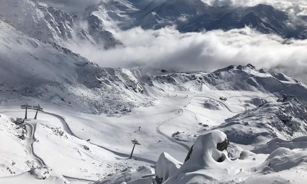
The ski area is divided into four sectors: Medran, Les Savoleyres, Mont Fort and Bruson. Verbier forms the western section of the 4 Valleys ski area. A 4 Valley pass allows a tour all the way from Verbier to La Tzoumaz, Nendaz, Veysonnaz, Les Masses, Thyon and back.
The Verbier section of the 4 Valleys ski area has recent lifts made by Leitner, CWA, Poma and Garaventa AG, all operated by Téléverbier SA. In Verbier alone, there are 35 lifts (within the Verbier, Savoleyeres/La Tzoumaz and Bruson sector). A standard Verbier pass gives access to this entire sector, 33 standard ski runs, two snowparks, one "Jardin de Neige" (a relatively flat area that is used for small children learning to ski), four cross-country pistes and two walking areas.
Resort cameras
Médran · 1,530 m · Live video
Open camera page ↗Les Attelas · 2,700 m · Panorama
Open camera page ↗Preparing forecast graphs…
Times and values match the detailed forecast. Tap or point at a value for details. Scroll each chart sideways for later days. Rain / precipitation is the total water equivalent per forecast interval, including snow; snowfall is fresh snow per interval, not snow depth.
GFS and ECMWF model comparison. Each model retains its own forecast times and horizon. Precipitation and snowfall amounts cover their own forecast intervals; these can differ between models.
Forecast values and model notes
Verbier - Middle - Les Ruinettes
ECMWF · Model run: Next update expected:
Day Time (UTC) Temp. (°C) Humidity (%) Wind (km/h) Wind (knots) Wind (Bft) Direction Precip. (mm) Snow (cm) Pressure (hPa) Freezing (m) Conditions | Thursday, 05/11 06:00 -1.7 83 9 5 2B SE — — 1024 < 2099 Overcast 93% cloud 09:00 1 73 8 5 2B SE 0.06 0 1025 2396 Cloudy 69% cloud 12:00 3.4 66 8 4 2B SE 0.00 0 1023 2691 Cloudy 79% cloud 15:00 3.1 69 6 3 2B SE 0 0 1022 2695 Partly cloudy 48% cloud 18:00 -0.6 83 5 3 1B SE 0.00 0 1022 < 2099 Overcast 94% cloud 21:00 -0.2 86 5 3 1B SE 0.72 0.2 1023 2129 Overcast 99% cloud Friday, 06/11 00:00 -0.7 91 3 2 1B SE 0.71 0.2 1023 < 2099 Overcast 100% cloud 03:00 -0.7 93 3 2 1B SE 1.4 0.4 1022 < 2099 Overcast 99% cloud 06:00 -1.7 93 1 1 1B SE 0.45 0.1 1021 < 2099 Cloudy 72% cloud 09:00 -0 87 1 1 1B SE 0.09 0 1022 2191 Cloudy 76% cloud 12:00 1.1 84 1 1 1B W 0.17 0 1021 2367 Overcast 80% cloud 15:00 -0.3 99 4 2 1B NW 0.59 0.2 1021 2135 Overcast 100% cloud 18:00 -1.4 99 3 2 1B NW 1.4 0.4 1023 < 2099 Overcast 100% cloud 21:00 -2 99 2 1 1B NW 1.5 0.5 1024 < 2099 Overcast 100% cloud Saturday, 07/11 00:00 -2.1 98 2 1 1B NW 0.98 0.3 1024 < 2099 Overcast 100% cloud 03:00 -2.3 97 1 0 0B N 0.12 0 1023 < 2099 Overcast 100% cloud 06:00 -2 97 0 0 0B E 0.04 0 1024 < 2099 Overcast 94% cloud 09:00 -0.6 84 3 1 1B S 0 0 1024 2100 Cloudy 72% cloud 12:00 1.4 69 3 2 1B S 0.00 0 1022 2366 Clear 15% cloud 15:00 0.7 67 2 1 1B SW 0.00 0 1022 2291 Partly cloudy 23% cloud 18:00 -2 79 1 1 0B S 0 0 1023 < 2099 Partly cloudy 25% cloud 21:00 -3.7 78 2 1 1B SE 0 0 1025 < 2099 Partly cloudy 35% cloud Sunday, 08/11 00:00 -4.9 70 2 1 1B SE 0 0 1025 < 2099 Partly cloudy 37% cloud 03:00 -5.8 68 1 1 1B SE 0 0 1024 < 2099 Partly cloudy 41% cloud 06:00 -6.4 76 2 1 1B SE 0 0 1024 < 2099 Partly cloudy 48% cloud 09:00 -0.4 55 1 0 0B SW 0 0 1025 2118 Clear 9% cloud 12:00 2.2 45 3 1 1B SW 0 0 1022 2465 Partly cloudy 21% cloud 15:00 0.9 48 2 1 1B W 0 0 1022 2322 Cloudy 74% cloud 18:00 -3.5 62 1 1 1B SW 0 0 1022 < 2099 Cloudy 60% cloud 21:00 -2.9 67 2 1 1B S 0 0 1022 < 2099 Overcast 94% cloud Monday, 09/11 00:00 -2 70 2 1 1B S 0.00 0 1022 < 2099 Overcast 98% cloud 03:00 -2.2 74 2 1 1B S 0 0 1020 < 2099 Overcast 84% cloud 06:00 -3 75 2 1 1B S 0 0 1020 < 2099 Cloudy 67% cloud 09:00 2 64 3 1 1B S 0 0 1020 2541 Cloudy 79% cloud 12:00 3.8 65 3 2 1B SW 0 0 1018 2737 Overcast 99% cloud 15:00 3 75 4 2 1B SW 0.23 0 1016 2709 Overcast 100% cloud 18:00 1.5 85 2 1 1B S 0.37 0 1017 2570 Overcast 100% cloud 21:00 1.1 89 2 1 1B S 0.17 0 1017 2523 Overcast 100% cloud Tuesday, 10/11 00:00 1.3 91 1 1 1B S 0.29 0 1016 2602 Overcast 100% cloud 03:00 1.4 92 1 1 0B W 0.49 0 1015 2634 Overcast 97% cloud 06:00 1.8 92 1 0 0B W 0.78 0 1014 2753 Overcast 100% cloud 09:00 2.7 93 1 1 1B W 1.2 0 1014 2874 Overcast 100% cloud 12:00 3.9 91 1 1 1B W 0.80 0 1014 2931 Overcast 83% cloud 15:00 4 90 2 1 1B W 0.16 0 1013 2898 Cloudy 63% cloud 18:00 1.5 92 1 0 0B W 0.09 0 1013 2796 Overcast 85% cloud 21:00 -0.4 92 1 1 1B SE 0 0 1013 2849 Cloudy 58% cloud Wednesday, 11/11 00:00 -0.3 87 1 0 0B SE 0 0 1013 2532 Clear 10% cloud 03:00 0.7 76 1 0 0B S 0 0 1012 3042 Partly cloudy 42% cloud 06:00 0 80 1 0 0B SE 0 0 1012 3043 Cloudy 54% cloud |
|---|
Forecast notes
Forecast table times: UTC.
Coordinates: 46.0912007°N, 7.2529037°E · Requested elevation: 2191 m. Model terrain: 2096 m. Terrain and 1000/925/850/700 hPa profiles are used for height estimates.
These are altitude estimates, not a simulation of local mountain terrain. Precipitation, cloud and sea-level pressure use horizontal interpolation only.
Precipitation includes rain and snow water equivalent: preceding 3 hours through day 6, then 6 hours (see cell tooltip). Snow (cm) estimates fresh snowfall from precipitation and temperature using the GFS conversion; it is not snow depth on the ground. Freezing (m) uses additional 600/500 hPa temperatures when available and estimates the lowest resolved 0°C crossing above sea level. When all sampled levels are warm, the upper profile limit is shown (see tooltip). < marks an entirely cold sampled profile and its lower height limit. No extrapolation is used.
Preparing forecast graphs…
Times and values match the detailed forecast. Tap or point at a value for details. Scroll each chart sideways for later days. Rain / precipitation is the total water equivalent per forecast interval, including snow; snowfall is fresh snow per interval, not snow depth.
GFS and ECMWF model comparison. Each model retains its own forecast times and horizon. Precipitation and snowfall amounts cover their own forecast intervals; these can differ between models.
Forecast values and model notes
Verbier - Top - Mont Fort
ECMWF · Model run: Next update expected:
Day Time (UTC) Temp. (°C) Humidity (%) Wind (km/h) Wind (knots) Wind (Bft) Direction Precip. (mm) Snow (cm) Pressure (hPa) Freezing (m) Conditions | Thursday, 05/11 06:00 -5.5 78 28 15 4B SE — — 1024 < 2249 Overcast 94% cloud 09:00 -5 77 27 15 4B SE 0.07 0.1 1025 2328 Cloudy 73% cloud 12:00 -4.3 78 22 12 4B SE 0.01 0 1024 2651 Overcast 81% cloud 15:00 -3.9 74 19 10 3B SE 0 0 1023 2639 Cloudy 56% cloud 18:00 -3.7 79 18 10 3B SE 0.02 0 1022 < 2249 Overcast 95% cloud 21:00 -4.4 95 23 13 4B SE 0.75 0.7 1023 < 2249 Overcast 99% cloud Friday, 06/11 00:00 -4.7 97 16 8 3B SE 0.88 0.9 1023 < 2249 Overcast 100% cloud 03:00 -5.1 98 15 8 3B SE 1.3 1.3 1022 < 2249 Overcast 99% cloud 06:00 -5.3 99 9 5 2B SE 0.38 0.4 1021 < 2249 Cloudy 79% cloud 09:00 -5.9 99 6 3 2B S 0.06 0.1 1022 < 2249 Overcast 82% cloud 12:00 -6 99 4 2 1B S 0.14 0.1 1021 2376 Overcast 84% cloud 15:00 -6.6 100 3 2 1B NW 0.55 0.5 1021 < 2249 Overcast 100% cloud 18:00 -7.2 100 9 5 2B N 1.3 1.3 1022 < 2249 Overcast 100% cloud 21:00 -7.6 100 9 5 2B N 1.3 1.3 1023 < 2249 Overcast 100% cloud Saturday, 07/11 00:00 -7.9 100 7 4 2B N 0.84 0.8 1024 < 2249 Overcast 100% cloud 03:00 -8 100 4 2 1B N 0.14 0.1 1023 < 2249 Overcast 99% cloud 06:00 -8.1 94 3 1 1B E 0.03 0 1024 < 2249 Overcast 95% cloud 09:00 -7.6 84 8 4 2B S 0 0 1024 < 2249 Cloudy 72% cloud 12:00 -7.3 72 10 6 2B S 0.01 0 1022 2370 Partly cloudy 29% cloud 15:00 -7.5 72 8 5 2B SW 0.02 0 1022 2293 Partly cloudy 29% cloud 18:00 -7.5 59 8 4 2B SW 0 0 1024 < 2249 Partly cloudy 27% cloud 21:00 -7 43 8 4 2B SW 0 0 1025 < 2249 Partly cloudy 35% cloud Sunday, 08/11 00:00 -6.7 38 11 6 2B SW 0 0 1025 < 2249 Partly cloudy 41% cloud 03:00 -7 41 11 6 2B W 0 0 1024 < 2249 Partly cloudy 36% cloud 06:00 -6.4 32 12 6 2B SW 0 0 1024 < 2249 Partly cloudy 43% cloud 09:00 -6.2 31 14 8 3B W 0 0 1025 < 2249 Clear 8% cloud 12:00 -6.6 37 15 8 3B SW 0 0 1023 2448 Clear 20% cloud 15:00 -6.9 47 16 9 3B SW 0 0 1023 2257 Cloudy 68% cloud 18:00 -7 72 17 9 3B W 0 0 1023 < 2249 Cloudy 55% cloud 21:00 -6.7 85 18 10 3B SW 0 0 1023 < 2249 Overcast 93% cloud Monday, 09/11 00:00 -5.9 88 19 10 3B W 0.02 0 1022 < 2249 Overcast 98% cloud 03:00 -5 85 21 11 4B W 0 0 1021 < 2249 Overcast 84% cloud 06:00 -4.6 80 22 12 4B SW 0 0 1020 < 2249 Cloudy 67% cloud 09:00 -4.5 89 26 14 4B SW 0 0 1020 2465 Cloudy 78% cloud 12:00 -3.9 96 29 16 5B SW 0 0 1018 2723 Overcast 99% cloud 15:00 -3.6 100 29 16 5B SW 0.27 0.3 1017 2682 Overcast 100% cloud 18:00 -3.5 100 24 13 4B SW 0.39 0.4 1017 2509 Overcast 100% cloud 21:00 -3.3 100 21 11 4B SW 0.15 0.2 1017 2461 Overcast 100% cloud Tuesday, 10/11 00:00 -3 100 23 12 4B SW 0.31 0.3 1016 2562 Overcast 100% cloud 03:00 -2.8 100 23 12 4B W 0.42 0.1 1015 2596 Overcast 98% cloud 06:00 -2.5 100 18 10 3B W 0.69 0.2 1014 2741 Overcast 100% cloud 09:00 -2.3 100 22 12 4B W 1.1 0.3 1014 2865 Overcast 100% cloud 12:00 -2.2 100 19 10 3B W 0.82 0.2 1014 2928 Overcast 87% cloud 15:00 -2.4 100 16 9 3B W 0.17 0 1013 2904 Cloudy 69% cloud 18:00 -2.2 89 10 5 2B W 0.06 0 1013 2733 Overcast 87% cloud 21:00 -1.5 74 6 3 2B W 0 0 1013 3016 Cloudy 64% cloud Wednesday, 11/11 00:00 -1.1 62 7 4 2B SW 0 0 1013 2881 Partly cloudy 23% cloud 03:00 -1.3 66 8 4 2B SW 0 0 1012 2860 Partly cloudy 49% cloud 06:00 -1.6 71 8 4 2B SW 0 0 1012 3038 Cloudy 54% cloud |
|---|
Forecast notes
Forecast table times: UTC.
Coordinates: 46.0800833°N, 7.3182579°E · Requested elevation: 3330 m. Model terrain: 2247 m. Terrain and 1000/925/850/700 hPa profiles are used for height estimates.
Outside the available profile, temperature uses an estimated 5.5°C/km height correction; wind retains the nearest available model-level value. Humidity is estimated with adjusted pressure and temperature.
These are altitude estimates, not a simulation of local mountain terrain. Precipitation, cloud and sea-level pressure use horizontal interpolation only.
Precipitation includes rain and snow water equivalent: preceding 3 hours through day 6, then 6 hours (see cell tooltip). Snow (cm) estimates fresh snowfall from precipitation and temperature using the GFS conversion; it is not snow depth on the ground. Freezing (m) uses additional 600/500 hPa temperatures when available and estimates the lowest resolved 0°C crossing above sea level. When all sampled levels are warm, the upper profile limit is shown (see tooltip). < marks an entirely cold sampled profile and its lower height limit. No extrapolation is used.