Worldwide Ski Resort Forecasts

More
Colour guide Temperature · Wind · Rain · Snow
Each colour starts at the value shown. Wind colours match across all three units. Dry cells stay neutral. Colours describe the displayed values, not official weather warnings.
Elatochori Ski Area - Base 1435
ECMWF · Model run: Next update expected:
Day Time (UTC) Temp. (°C) Humidity (%) Wind (km/h) Wind (knots) Wind (Bft) Direction Precip. (mm) Snow (cm) Pressure (hPa) Freezing (m) Conditions | Thursday, 05/11 06:00 3.6 98 9 5 2B E — — 1027 2098 Overcast 100% cloud  09:00 3.6 98 7 4 2B E 0.57 0 1028 2059 Overcast 100% cloud 12:00 3.4 97 3 2 1B SE 0.70 0 1028 2052 Overcast 100% cloud 15:00 3.4 97 2 1 1B N 0.55 0 1027 2064 Overcast 99% cloud 18:00 3.3 97 4 2 1B N 0.25 0 1027 2095 Overcast 90% cloud 21:00 3 98 5 3 1B N 0.13 0 1027 2088 Overcast 87% cloud Friday, 06/11 00:00 2.7 97 5 3 1B NE 0.12 0 1026 2129 Cloudy 67% cloud  03:00 2.6 94 3 1 1B N 0.09 0 1025 2201 Cloudy 62% cloud 06:00 2.3 92 2 1 1B NW 0.01 0 1024 2178 Cloudy 64% cloud 09:00 3 86 3 2 1B NW 0.09 0 1024 2286 Cloudy 75% cloud 12:00 4.4 80 8 4 2B NW 0.16 0 1022 2484 Cloudy 52% cloud 15:00 4.9 76 10 5 2B NW 0 0 1021 2600 Clear 2% cloud  18:00 5.2 62 11 6 2B NW 0 0 1021 2762 Clear 3% cloud 21:00 5.1 59 9 5 2B N 0 0 1022 2740 Clear 1% cloud Saturday, 07/11 00:00 4.8 46 6 3 2B N 0 0 1022 2654 Clear 1% cloud 03:00 4 47 7 4 2B NE 0 0 1022 2555 Clear 3% cloud 06:00 2.9 65 5 3 1B NE 0 0 1024 2416 Cloudy 63% cloud 09:00 2.9 72 2 1 1B E 0 0 1025 2286 Cloudy 64% cloud 12:00 3.6 79 2 1 1B S 0 0 1024 2323 Cloudy 74% cloud 15:00 3 85 4 2 1B W 0 0 1025 2268 Partly cloudy 32% cloud  18:00 2.6 84 2 1 1B NW 0 0 1026 2168 Cloudy 74% cloud 21:00 2.3 81 3 2 1B NE 0 0 1028 2079 Partly cloudy 46% cloud Sunday, 08/11 00:00 1.8 83 5 3 1B SE 0.01 0 1029 1903 Cloudy 79% cloud 03:00 1.5 98 9 5 2B SE 0.09 0 1029 1822 Overcast 100% cloud 06:00 1.4 99 10 5 2B SE 0.30 0 1031 1763 Overcast 100% cloud 09:00 1.6 99 6 3 2B S 0.45 0 1031 1790 Overcast 99% cloud 12:00 2.3 96 4 2 1B SW 0.59 0 1030 1948 Overcast 93% cloud 15:00 2.4 95 6 3 2B W 0.31 0 1030 2032 Overcast 91% cloud 18:00 2.4 90 3 2 1B W 0 0 1031 2031 Overcast 84% cloud 21:00 2.6 82 0 0 0B W 0 0 1031 2117 Cloudy 73% cloud Monday, 09/11 00:00 2.7 78 2 1 1B S 0 0 1030 2196 Overcast 86% cloud 03:00 2.7 74 5 3 1B SW 0 0 1030 2208 Overcast 98% cloud 06:00 3.6 70 6 3 2B SW 0.03 0 1030 2303 Overcast 97% cloud 09:00 4.2 70 11 6 2B SW 0.05 0 1030 2317 Overcast 91% cloud 12:00 4.1 86 12 6 2B SW 0.91 0 1029 2341 Overcast 99% cloud 15:00 4.6 88 10 5 2B SW 3.3 0 1027 2464 Overcast 99% cloud 18:00 4.8 89 13 7 3B SW 0.45 0 1027 2477 Overcast 83% cloud 21:00 5.1 89 14 8 3B SW 0 0 1027 2525 Cloudy 56% cloud Tuesday, 10/11 00:00 5.4 90 16 9 3B W 0.08 0 1026 2541 Partly cloudy 33% cloud 03:00 5.3 86 15 8 3B W 0 0 1025 2583 Clear 11% cloud 06:00 5.4 81 11 6 2B W 0 0 1025 2659 Clear 6% cloud 09:00 6.4 83 12 6 2B W 0 0 1024 2836 Partly cloudy 49% cloud 12:00 6.9 78 14 8 3B W 0 0 1022 3008 Cloudy 69% cloud 15:00 7.1 80 16 9 3B W 0 0 1021 3055 Overcast 95% cloud 18:00 7.1 82 18 10 3B W 0 0 1021 3005 Partly cloudy 45% cloud 21:00 7.3 78 18 10 3B W 0 0 1021 2950 Overcast 89% cloud Wednesday, 11/11 00:00 7.7 76 19 10 3B W 0 0 1020 2953 Overcast 90% cloud 03:00 8.3 72 20 11 4B W 0 0 1018 2947 Cloudy 78% cloud 06:00 8.4 77 20 11 4B W 0 0 1018 3002 Overcast 84% cloud |
|---|
Forecast notes
Forecast table times: UTC.
Coordinates: 40.31788°N, 22.20903°E · Requested elevation: 1435 m. Model terrain: 764 m. Terrain and 1000/925/850/700 hPa profiles are used for height estimates.
These are altitude estimates, not a simulation of local mountain terrain. Precipitation, cloud and sea-level pressure use horizontal interpolation only.
Precipitation includes rain and snow water equivalent: preceding 3 hours through day 6, then 6 hours (see cell tooltip). Snow (cm) estimates fresh snowfall from precipitation and temperature using the GFS conversion; it is not snow depth on the ground. Freezing (m) uses additional 600/500 hPa temperatures when available and estimates the lowest resolved 0°C crossing above sea level. When all sampled levels are warm, the upper profile limit is shown (see tooltip). < marks an entirely cold sampled profile and its lower height limit. No extrapolation is used.
Source: ECMWF · CC BY 4.0 · Processed by Snow Report.
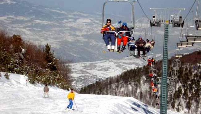
It is only 8 km from the picturesque village of Elatochori, 36 km from Katerini, 105 km from Thessaloniki and 120 km from Larissa.
Check current ski conditions at Snow Report Elatochori
Places to stay — Elatochori
Swipe to see all 5 places to stay →
 Mythos
Elatochori
Drive to ski centre: ≈ 8.5 km · 13 min
View on Booking.com ↗
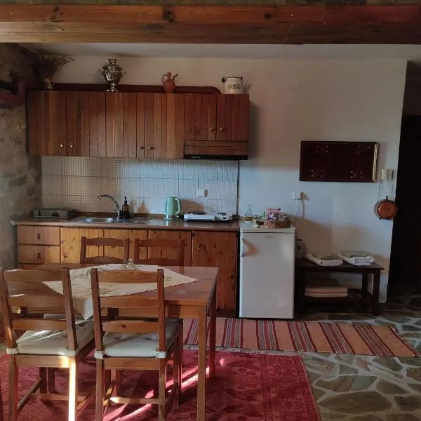 Studio in Elatochori - O Elato
Elatochori
Drive to ski centre: ≈ 8.3 km · 13 min
View on Booking.com ↗
 Elation Rooms
Elatochori
Drive to ski centre: ≈ 8.2 km · 13 min
View on Booking.com ↗
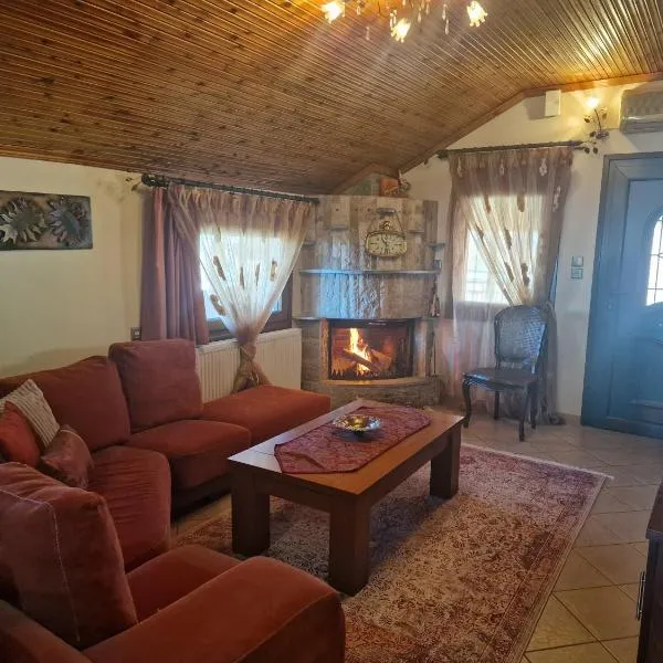 Guest house Elatochori
Elatochori
Drive to ski centre: ≈ 8.7 km · 14 min
View on Booking.com ↗
 ElatoVillage
Elatochori
Drive to ski centre: ≈ 8.6 km · 14 min
View on Booking.com ↗
Elatochori Ski Area - Middle 1685
ECMWF · Model run: Next update expected:
Day Time (UTC) Temp. (°C) Humidity (%) Wind (km/h) Wind (knots) Wind (Bft) Direction Precip. (mm) Snow (cm) Pressure (hPa) Freezing (m) Conditions | Thursday, 05/11 06:00 2.2 99 8 5 2B E — — 1027 2100 Overcast 100% cloud 09:00 2 99 7 4 2B SE 0.58 0 1028 2059 Overcast 100% cloud 12:00 2 97 2 1 1B SE 0.72 0 1028 2054 Overcast 100% cloud 15:00 2 97 4 2 1B NW 0.55 0 1027 2065 Overcast 99% cloud 18:00 2 96 7 4 2B N 0.25 0 1027 2094 Overcast 92% cloud 21:00 1.7 96 7 4 2B N 0.14 0 1027 2090 Overcast 89% cloud Friday, 06/11 00:00 1.6 93 7 4 2B N 0.12 0 1026 2129 Cloudy 67% cloud 03:00 1.6 88 6 3 2B N 0.09 0 1025 2202 Cloudy 61% cloud 06:00 1.3 85 5 3 1B N 0.00 0 1025 2180 Cloudy 63% cloud 09:00 1.7 81 5 3 1B N 0.09 0 1024 2288 Cloudy 77% cloud 12:00 3 76 9 5 2B NW 0.17 0 1022 2484 Cloudy 53% cloud 15:00 3.8 71 12 6 2B NW 0 0 1021 2600 Clear 2% cloud 18:00 4.4 57 13 7 3B NW 0 0 1021 2762 Clear 3% cloud 21:00 4.3 55 12 6 2B N 0 0 1022 2741 Clear 1% cloud Saturday, 07/11 00:00 4 40 8 4 2B N 0 0 1022 2654 Clear 1% cloud 03:00 3.3 40 8 4 2B NE 0 0 1022 2557 Clear 3% cloud 06:00 2.2 58 6 3 2B NE 0 0 1024 2418 Cloudy 63% cloud 09:00 1.6 68 2 1 1B NE 0 0 1025 2286 Cloudy 64% cloud 12:00 2.1 77 1 1 1B W 0 0 1024 2323 Cloudy 74% cloud 15:00 1.9 80 4 2 1B W 0 0 1025 2269 Partly cloudy 31% cloud 18:00 1.6 79 4 2 1B N 0 0 1026 2167 Cloudy 76% cloud 21:00 1.4 76 4 2 1B NE 0 0 1028 2080 Partly cloudy 49% cloud Sunday, 08/11 00:00 0.7 77 4 2 1B SE 0.02 0 1029 1903 Cloudy 78% cloud 03:00 0.4 94 8 4 2B SE 0.08 0 1029 1824 Overcast 100% cloud 06:00 0.3 95 9 5 2B SE 0.28 0.1 1031 1765 Overcast 100% cloud 09:00 0.3 95 6 3 1B S 0.45 0.1 1031 1794 Overcast 100% cloud 12:00 0.8 94 5 2 1B SW 0.58 0.2 1030 1949 Overcast 93% cloud 15:00 1.2 91 7 4 2B W 0.31 0 1030 2033 Overcast 91% cloud 18:00 1.3 86 5 3 1B W 0 0 1031 2029 Overcast 83% cloud 21:00 1.7 77 2 1 1B NW 0 0 1031 2116 Cloudy 72% cloud Monday, 09/11 00:00 1.9 74 2 1 1B W 0 0 1030 2196 Overcast 86% cloud 03:00 2 70 4 2 1B SW 0 0 1030 2207 Overcast 98% cloud 06:00 2.7 66 6 3 2B SW 0.03 0 1030 2303 Overcast 98% cloud 09:00 2.8 70 13 7 3B SW 0.04 0 1030 2317 Overcast 90% cloud 12:00 2.8 85 15 8 3B SW 0.96 0 1029 2342 Overcast 99% cloud 15:00 3.6 87 14 7 3B SW 3.3 0 1027 2465 Overcast 99% cloud 18:00 3.9 88 16 8 3B SW 0.41 0 1027 2478 Overcast 83% cloud 21:00 4.3 89 18 9 3B W 0 0 1027 2526 Cloudy 56% cloud Tuesday, 10/11 00:00 4.6 89 19 11 3B W 0.08 0 1026 2542 Partly cloudy 33% cloud 03:00 4.5 84 17 9 3B W 0 0 1025 2584 Clear 10% cloud 06:00 4.7 78 13 7 3B W 0 0 1025 2659 Clear 6% cloud 09:00 5 82 14 7 3B W 0 0 1024 2836 Partly cloudy 49% cloud 12:00 5.5 77 17 9 3B W 0 0 1022 3010 Cloudy 69% cloud 15:00 6.1 76 20 11 3B W 0 0 1021 3057 Overcast 96% cloud 18:00 6.3 79 21 11 4B W 0 0 1021 3008 Partly cloudy 44% cloud 21:00 6.5 76 21 11 4B W 0 0 1021 2950 Overcast 89% cloud Wednesday, 11/11 00:00 6.9 74 22 12 4B W 0 0 1020 2955 Overcast 90% cloud 03:00 7.4 71 22 12 4B W 0 0 1018 2947 Cloudy 78% cloud 06:00 7.5 76 22 12 4B W 0 0 1018 3000 Overcast 83% cloud |
|---|
Forecast notes
Forecast table times: UTC.
Coordinates: 40.306858°N, 22.209248°E · Requested elevation: 1685 m. Model terrain: 783 m. Terrain and 1000/925/850/700 hPa profiles are used for height estimates.
These are altitude estimates, not a simulation of local mountain terrain. Precipitation, cloud and sea-level pressure use horizontal interpolation only.
Precipitation includes rain and snow water equivalent: preceding 3 hours through day 6, then 6 hours (see cell tooltip). Snow (cm) estimates fresh snowfall from precipitation and temperature using the GFS conversion; it is not snow depth on the ground. Freezing (m) uses additional 600/500 hPa temperatures when available and estimates the lowest resolved 0°C crossing above sea level. When all sampled levels are warm, the upper profile limit is shown (see tooltip). < marks an entirely cold sampled profile and its lower height limit. No extrapolation is used.
Source: ECMWF · CC BY 4.0 · Processed by Snow Report.
Elatochori Ski Area - Top 1910
ECMWF · Model run: Next update expected:
Day Time (UTC) Temp. (°C) Humidity (%) Wind (km/h) Wind (knots) Wind (Bft) Direction Precip. (mm) Snow (cm) Pressure (hPa) Freezing (m) Conditions | Thursday, 05/11 06:00 1 99 6 3 2B E — — 1027 2104 Overcast 100% cloud 09:00 0.8 99 5 3 1B SE 0.58 0.2 1028 2061 Overcast 100% cloud 12:00 0.8 97 1 1 1B W 0.73 0.2 1028 2059 Overcast 100% cloud 15:00 0.8 97 6 3 2B NW 0.57 0.2 1027 2067 Overcast 99% cloud 18:00 0.9 95 9 5 2B N 0.26 0.1 1027 2096 Overcast 94% cloud 21:00 0.8 91 9 5 2B N 0.16 0 1027 2094 Overcast 90% cloud Friday, 06/11 00:00 0.8 85 9 5 2B N 0.16 0 1026 2130 Cloudy 69% cloud 03:00 0.9 79 10 5 2B N 0.12 0 1025 2205 Cloudy 62% cloud 06:00 0.7 76 9 5 2B N 0.00 0 1025 2184 Cloudy 64% cloud 09:00 1.1 73 8 4 2B N 0.09 0 1024 2293 Cloudy 77% cloud 12:00 2.2 69 11 6 2B NW 0.17 0 1022 2487 Cloudy 52% cloud 15:00 2.9 64 13 7 3B NW 0 0 1021 2601 Clear 2% cloud 18:00 3.5 53 15 8 3B N 0 0 1021 2762 Clear 3% cloud 21:00 3.4 52 14 7 3B N 0 0 1022 2743 Clear 1% cloud Saturday, 07/11 00:00 3.1 38 10 5 2B N 0 0 1022 2654 Clear 0% cloud 03:00 2.5 37 9 5 2B N 0 0 1022 2559 Clear 4% cloud 06:00 1.6 52 8 4 2B N 0 0 1024 2424 Cloudy 64% cloud 09:00 1 61 4 2 1B N 0 0 1025 2288 Cloudy 66% cloud 12:00 1.4 68 3 2 1B NW 0 0 1024 2324 Cloudy 73% cloud 15:00 1.2 71 5 3 1B NW 0 0 1025 2272 Partly cloudy 30% cloud 18:00 0.9 71 5 3 1B N 0 0 1026 2166 Cloudy 78% cloud 21:00 0.6 69 5 3 1B NE 0 0 1028 2083 Cloudy 53% cloud Sunday, 08/11 00:00 -0 68 2 1 1B E 0.02 0 1029 1905 Cloudy 78% cloud 03:00 -0.3 83 4 2 1B SE 0.10 0 1029 1826 Overcast 100% cloud 06:00 -0.5 85 5 3 1B SE 0.27 0.1 1030 1769 Overcast 100% cloud 09:00 -0.3 84 3 2 1B S 0.45 0.1 1031 1801 Overcast 100% cloud 12:00 0.1 83 4 2 1B W 0.57 0.2 1030 1954 Overcast 92% cloud 15:00 0.4 82 8 4 2B W 0.29 0.1 1030 2033 Overcast 90% cloud 18:00 0.4 80 6 3 2B NW 0 0 1031 2026 Overcast 80% cloud 21:00 0.8 73 5 3 1B NW 0 0 1031 2115 Cloudy 73% cloud Monday, 09/11 00:00 1.1 70 5 3 1B NW 0 0 1030 2196 Overcast 86% cloud 03:00 1.1 70 5 3 1B W 0 0 1030 2206 Overcast 98% cloud 06:00 1.7 69 6 3 2B SW 0.02 0 1030 2304 Overcast 98% cloud 09:00 1.8 72 12 7 2B SW 0.04 0 1030 2317 Overcast 90% cloud 12:00 1.9 87 16 9 3B SW 1.0 0 1029 2346 Overcast 100% cloud 15:00 2.5 89 18 10 3B SW 3.3 0 1027 2466 Overcast 100% cloud 18:00 2.8 90 18 10 3B W 0.37 0 1027 2480 Overcast 84% cloud 21:00 3.2 89 20 11 4B W 0 0 1027 2527 Cloudy 57% cloud Tuesday, 10/11 00:00 3.4 87 21 11 4B W 0.08 0 1026 2543 Partly cloudy 34% cloud 03:00 3.4 80 19 10 3B W 0 0 1025 2585 Clear 11% cloud 06:00 3.6 75 15 8 3B W 0 0 1025 2661 Clear 6% cloud 09:00 4 78 15 8 3B W 0 0 1024 2839 Partly cloudy 48% cloud 12:00 4.5 72 18 10 3B W 0 0 1022 3014 Cloudy 68% cloud 15:00 5.1 71 21 11 4B W 0 0 1021 3058 Overcast 96% cloud 18:00 5.2 75 22 12 4B W 0 0 1021 3008 Partly cloudy 43% cloud 21:00 5.3 73 22 12 4B W 0 0 1021 2950 Overcast 89% cloud Wednesday, 11/11 00:00 5.7 74 23 13 4B W 0 0 1020 2957 Overcast 91% cloud 03:00 6.1 72 24 13 4B W 0 0 1018 2947 Cloudy 78% cloud 06:00 6.2 76 23 12 4B W 0 0 1018 3000 Overcast 83% cloud |
|---|
Forecast notes
Forecast table times: UTC.
Coordinates: 40.295239°N, 22.200021°E · Requested elevation: 1910 m. Model terrain: 802 m. Terrain and 1000/925/850/700 hPa profiles are used for height estimates.
These are altitude estimates, not a simulation of local mountain terrain. Precipitation, cloud and sea-level pressure use horizontal interpolation only.
Precipitation includes rain and snow water equivalent: preceding 3 hours through day 6, then 6 hours (see cell tooltip). Snow (cm) estimates fresh snowfall from precipitation and temperature using the GFS conversion; it is not snow depth on the ground. Freezing (m) uses additional 600/500 hPa temperatures when available and estimates the lowest resolved 0°C crossing above sea level. When all sampled levels are warm, the upper profile limit is shown (see tooltip). < marks an entirely cold sampled profile and its lower height limit. No extrapolation is used.