Kitzsteinhorn summit · 3,029 m · Feratel

Camera image unavailable
Camera image · refreshes every 60 seconds while visible.
Open camera page ↗
Each colour starts at the value shown. Wind colours match across all three units. Dry cells stay neutral. Colours describe the displayed values, not official weather warnings.
ECMWF · Model run: Next update expected:
Day Time (UTC) Temp. (°C) Humidity (%) Wind (km/h) Wind (knots) Wind (Bft) Direction Precip. (mm) Snow (cm) Pressure (hPa) Freezing (m) Conditions | Thursday, 05/11 06:00 0.8 63 3 2 1B S — — 1025 < 1525 Partly cloudy 28% cloud  09:00 8.8 50 2 1 1B E 0 0 1025 2987 Clear 13% cloud  12:00 12.4 43 2 1 1B NE 0 0 1023 3087 Clear 7% cloud 15:00 10 52 1 0 0B SE 0 0 1022 3124 Clear 2% cloud 18:00 4.9 49 2 1 1B S 0 0 1022 3128 Clear 0% cloud 21:00 6.1 42 1 0 0B S 0 0 1022 3126 Clear 0% cloud Friday, 06/11 00:00 6 36 1 1 0B S 0 0 1021 3118 Clear 0% cloud 03:00 5.9 34 1 0 0B S 0 0 1021 3111 Clear 0% cloud 06:00 5.8 31 1 0 0B S 0 0 1020 3104 Clear 0% cloud 09:00 10.8 31 1 1 1B NE 0 0 1020 3105 Clear 0% cloud 12:00 13.2 37 2 1 1B NE 0 0 1018 3098 Clear 0% cloud 15:00 9.8 49 1 0 0B NW 0 0 1017 3064 Clear 2% cloud 18:00 4.1 58 2 1 1B SW 0 0 1020 2165 Overcast 89% cloud  21:00 2.5 62 1 1 1B SW 0 0 1022 < 1525 Partly cloudy 47% cloud Saturday, 07/11 00:00 1.8 59 1 1 1B SW 0 0 1022 < 1525 Cloudy 65% cloud  03:00 2.2 59 1 0 0B SW 0 0 1023 < 1525 Cloudy 71% cloud 06:00 2.7 61 0 0 0B SW 0.00 0 1024 < 1525 Overcast 82% cloud 09:00 6.1 60 1 1 1B N 0.22 0 1025 2115 Cloudy 64% cloud 12:00 9 52 3 2 1B NE 0.00 0 1023 2436 Partly cloudy 26% cloud 15:00 7.2 56 1 0 0B N 0 0 1022 2283 Clear 5% cloud 18:00 2.5 59 2 1 1B S 0 0 1023 < 1525 Clear 0% cloud 21:00 1.9 49 2 1 1B S 0 0 1024 < 1525 Clear 0% cloud Sunday, 08/11 00:00 2 43 1 1 1B S 0 0 1024 < 1525 Clear 0% cloud 03:00 2.3 40 1 1 0B S 0 0 1023 < 1525 Clear 0% cloud 06:00 2.9 40 1 0 0B S 0 0 1024 < 1525 Clear 0% cloud 09:00 8.4 33 1 1 1B N 0 0 1024 2271 Clear 0% cloud 12:00 10.6 34 2 1 1B NE 0 0 1022 2414 Clear 7% cloud 15:00 7.6 46 1 1 1B NW 0 0 1022 2111 Clear 17% cloud 18:00 4.1 54 2 1 1B SW 0 0 1023 1670 Clear 18% cloud 21:00 2.6 55 2 1 1B S 0 0 1024 < 1525 Clear 2% cloud Monday, 09/11 00:00 2.7 55 2 1 1B S 0 0 1023 < 1525 Clear 0% cloud 03:00 2.4 53 2 1 1B S 0 0 1022 < 1525 Clear 0% cloud 06:00 2.7 45 2 1 1B S 0 0 1021 < 1525 Clear 0% cloud 09:00 9.4 31 2 1 1B E 0 0 1020 2378 Partly cloudy 34% cloud 12:00 11.3 34 1 0 0B SE 0 0 1017 2545 Overcast 97% cloud 15:00 8 48 1 1 1B S 0 0 1016 2441 Overcast 100% cloud 18:00 5.9 58 4 2 1B S 0.12 0 1015 2233 Overcast 100% cloud 21:00 5.8 66 3 1 1B S 0.37 0 1016 2217 Overcast 100% cloud Tuesday, 10/11 00:00 5.4 72 2 1 1B S 1.2 0 1017 2141 Overcast 100% cloud 03:00 5.7 72 1 1 1B S 1.1 0 1015 2205 Overcast 100% cloud 06:00 5.9 74 1 0 0B S 2.2 0 1015 2254 Overcast 100% cloud 09:00 7 77 0 0 0B — 0.61 0 1015 2395 Overcast 100% cloud 12:00 7.8 81 0 0 0B W 0.51 0 1014 2457 Overcast 100% cloud 15:00 7.5 78 1 1 1B W 0.27 0 1014 2436 Overcast 100% cloud 18:00 7.4 75 1 0 0B SW 0.24 0 1015 2402 Overcast 99% cloud 21:00 7.2 74 1 0 0B S 0 0 1015 2398 Cloudy 69% cloud Wednesday, 11/11 00:00 7 74 1 0 0B S 0 0 1015 2428 Overcast 83% cloud 03:00 6.7 70 1 1 1B S 0 0 1014 2456 Clear 5% cloud 06:00 6.1 67 2 1 1B S 0 0 1013 2530 Clear 5% cloud |
|---|
Forecast table times: UTC.
Coordinates: 47.27358041°N, 12.74731636°E · Requested elevation: 911 m. Model terrain: 1522 m. Terrain and 1000/925/850/700 hPa profiles are used for height estimates.
Outside the available profile, temperature uses an estimated 5.5°C/km height correction; wind retains the nearest available model-level value. Humidity is estimated with adjusted pressure and temperature.
These are altitude estimates, not a simulation of local mountain terrain. Precipitation, cloud and sea-level pressure use horizontal interpolation only.
Precipitation includes rain and snow water equivalent: preceding 3 hours through day 6, then 6 hours (see cell tooltip). Snow (cm) estimates fresh snowfall from precipitation and temperature using the GFS conversion; it is not snow depth on the ground. Freezing (m) uses additional 600/500 hPa temperatures when available and estimates the lowest resolved 0°C crossing above sea level. When all sampled levels are warm, the upper profile limit is shown (see tooltip). < marks an entirely cold sampled profile and its lower height limit. No extrapolation is used.
Source: ECMWF · CC BY 4.0 · Processed by Snow Report.
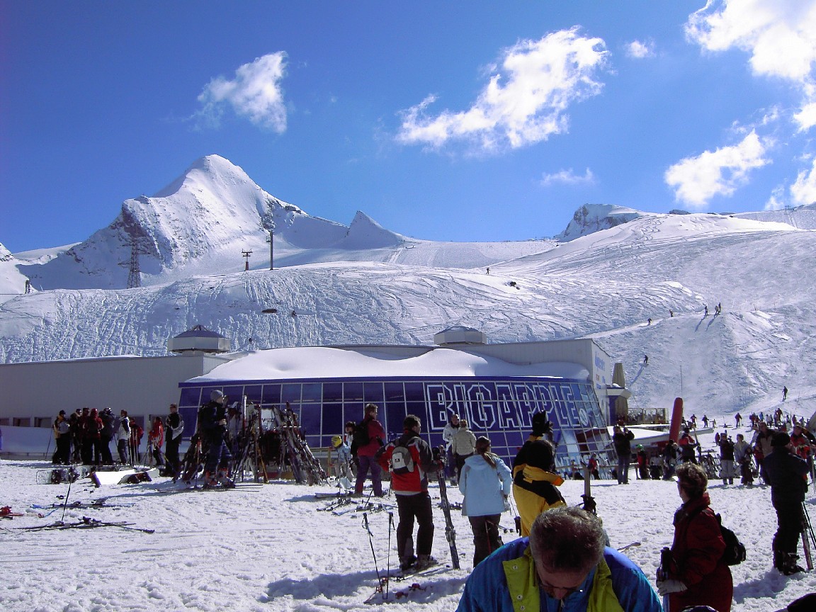
Kaprun brings together the lower Maiskogel mountain and the Kitzsteinhorn glacier area. The MK Maiskogelbahn and 3K K-onnection allow an ascent from Kaprun through Maiskogel towards the glacier, while the Gletscherjet valley station offers another starting point. It is worth identifying your departure station before choosing transport or checking the day’s lift information.
This page opens at 911 m, a lower reference in the Kaprun area. That is a very different setting from the glacier. A warm or rainy forecast at the selected point is not a report of conditions throughout Kitzsteinhorn. Choose one of the higher forecast points when planning a mountain day, and compare it with the lower point for your return.
For families or groups with different plans, Maiskogel and the glacier need not be treated as the same outing. Check the facilities you intend to use rather than relying on a single headline for the entire destination. During changing weather, follow the wind and cloud forecast as well as the amount of fresh snow. The operator’s current report confirms which parts of the lift route and pistes are actually available.
Official sources: Kitzsteinhorn — Kaprun–Maiskogel connection · Kaprun skiing. Reviewed 18 October 2026.
Camera image · refreshes every 60 seconds while visible.
Open camera page ↗
Camera image · refreshes every 60 seconds while visible.
Open camera page ↗
Camera image · refreshes every 60 seconds while visible.
Open camera page ↗ECMWF · Model run: Next update expected:
Day Time (UTC) Temp. (°C) Humidity (%) Wind (km/h) Wind (knots) Wind (Bft) Direction Precip. (mm) Snow (cm) Pressure (hPa) Freezing (m) Conditions | Thursday, 05/11 06:00 -3.5 63 4 2 1B S — — 1025 < 1645 Partly cloudy 25% cloud 09:00 3.5 53 2 1 1B SE 0 0 1025 2945 Clear 10% cloud 12:00 6.2 45 1 1 1B S 0 0 1023 3072 Clear 5% cloud 15:00 4.4 53 1 1 1B S 0 0 1022 3124 Clear 1% cloud 18:00 0.4 50 2 1 1B S 0 0 1022 3128 Clear 0% cloud 21:00 1.1 43 2 1 1B S 0 0 1022 3126 Clear 0% cloud Friday, 06/11 00:00 1.2 36 2 1 1B S 0 0 1021 3118 Clear 0% cloud 03:00 1 35 2 1 1B S 0 0 1020 3111 Clear 0% cloud 06:00 0.9 32 1 1 1B S 0 0 1020 3104 Clear 0% cloud 09:00 5.4 32 3 2 1B SE 0 0 1020 3105 Clear 0% cloud 12:00 7 39 4 2 1B SE 0 0 1018 3098 Clear 0% cloud 15:00 4.3 51 4 2 1B S 0 0 1018 3016 Clear 2% cloud 18:00 -0.1 58 5 3 1B S 0 0 1020 1921 Overcast 95% cloud 21:00 -1.4 59 6 3 2B S 0 0 1022 < 1645 Cloudy 54% cloud Saturday, 07/11 00:00 -2.2 59 7 4 2B S 0 0 1022 < 1645 Cloudy 67% cloud 03:00 -2.2 64 6 3 1B S 0 0 1023 < 1645 Overcast 81% cloud 06:00 -1.9 73 7 4 2B SE 0.08 0 1024 < 1645 Overcast 89% cloud 09:00 0.6 72 7 4 2B SE 0.23 0 1025 2097 Cloudy 72% cloud 12:00 2.8 57 6 3 2B SE 0 0 1023 2418 Partly cloudy 26% cloud 15:00 1.3 61 7 4 2B SE 0 0 1023 2230 Clear 4% cloud 18:00 -2.1 61 8 5 2B S 0 0 1024 < 1645 Clear 0% cloud 21:00 -2.9 57 8 4 2B S 0 0 1025 < 1645 Clear 0% cloud Sunday, 08/11 00:00 -2.8 51 8 4 2B S 0 0 1024 < 1645 Clear 0% cloud 03:00 -2.6 47 6 3 2B S 0 0 1023 < 1645 Clear 0% cloud 06:00 -2.6 51 4 2 1B S 0 0 1024 < 1645 Clear 0% cloud 09:00 2.1 44 3 1 1B S 0 0 1024 2271 Clear 0% cloud 12:00 3.6 46 3 2 1B S 0 0 1022 2410 Clear 8% cloud 15:00 0.9 60 3 2 1B SW 0 0 1022 2102 Clear 20% cloud 18:00 -1.9 69 3 2 1B W 0 0 1023 < 1645 Clear 18% cloud 21:00 -3.1 69 2 1 1B W 0 0 1024 < 1645 Clear 1% cloud Monday, 09/11 00:00 -3.1 63 3 2 1B W 0 0 1023 < 1645 Clear 0% cloud 03:00 -3.2 59 4 2 1B W 0 0 1022 < 1645 Clear 0% cloud 06:00 -3 56 5 3 1B W 0 0 1022 < 1645 Clear 0% cloud 09:00 2.9 41 4 2 1B W 0 0 1021 2382 Partly cloudy 46% cloud 12:00 4.4 44 5 3 1B SW 0 0 1018 2544 Overcast 94% cloud 15:00 2.1 58 7 4 2B SW 0 0 1016 2412 Overcast 96% cloud 18:00 0.6 71 9 5 2B SW 0.11 0 1016 2144 Overcast 100% cloud 21:00 0.5 82 10 5 2B W 0.39 0.1 1017 2151 Overcast 99% cloud Tuesday, 10/11 00:00 0.4 87 8 4 2B W 1.1 0.3 1017 2092 Overcast 99% cloud 03:00 0.6 87 10 5 2B W 0.96 0.3 1015 2175 Overcast 100% cloud 06:00 0.8 89 9 5 2B W 2.0 0.6 1015 2234 Overcast 100% cloud 09:00 1.9 89 9 5 2B W 0.52 0 1015 2435 Overcast 98% cloud 12:00 2.5 92 9 5 2B W 0.43 0 1014 2500 Overcast 100% cloud 15:00 2.2 92 9 5 2B W 0.26 0 1014 2455 Overcast 100% cloud 18:00 1.9 89 8 4 2B NW 0.24 0 1014 2402 Overcast 98% cloud 21:00 1.8 88 7 4 2B NW 0 0 1015 2407 Cloudy 69% cloud Wednesday, 11/11 00:00 1.7 87 6 3 2B W 0 0 1015 2410 Overcast 81% cloud 03:00 1.4 76 4 2 1B W 0 0 1013 2401 Clear 6% cloud 06:00 1 74 4 2 1B W 0 0 1013 2416 Clear 2% cloud |
|---|
Forecast table times: UTC.
Coordinates: 47.22090889°N, 12.69907951°E · Requested elevation: 1970 m. Model terrain: 1643 m. Terrain and 1000/925/850/700 hPa profiles are used for height estimates.
These are altitude estimates, not a simulation of local mountain terrain. Precipitation, cloud and sea-level pressure use horizontal interpolation only.
Precipitation includes rain and snow water equivalent: preceding 3 hours through day 6, then 6 hours (see cell tooltip). Snow (cm) estimates fresh snowfall from precipitation and temperature using the GFS conversion; it is not snow depth on the ground. Freezing (m) uses additional 600/500 hPa temperatures when available and estimates the lowest resolved 0°C crossing above sea level. When all sampled levels are warm, the upper profile limit is shown (see tooltip). < marks an entirely cold sampled profile and its lower height limit. No extrapolation is used.
Source: ECMWF · CC BY 4.0 · Processed by Snow Report.
ECMWF · Model run: Next update expected:
Day Time (UTC) Temp. (°C) Humidity (%) Wind (km/h) Wind (knots) Wind (Bft) Direction Precip. (mm) Snow (cm) Pressure (hPa) Freezing (m) Conditions | Thursday, 05/11 06:00 -1.4 32 7 4 2B SW — — 1025 < 1732 Partly cloudy 23% cloud 09:00 -0.4 32 5 3 1B S 0 0 1025 2915 Clear 8% cloud 12:00 0.2 27 7 4 2B SW 0 0 1023 3060 Clear 4% cloud 15:00 0.5 23 3 2 1B S 0 0 1022 3124 Clear 1% cloud 18:00 0.1 23 5 3 1B S 0 0 1023 2226 Clear 0% cloud 21:00 0.3 21 5 3 1B S 0 0 1023 3127 Clear 0% cloud Friday, 06/11 00:00 0.4 18 6 3 2B S 0 0 1021 3118 Clear 0% cloud 03:00 0.3 19 5 2 1B SW 0 0 1021 3111 Clear 0% cloud 06:00 0.1 18 2 1 1B SE 0 0 1020 3104 Clear 0% cloud 09:00 0.6 18 11 6 2B SE 0 0 1020 3105 Clear 0% cloud 12:00 0.5 22 16 9 3B S 0 0 1018 3098 Clear 0% cloud 15:00 -0.2 25 16 9 3B S 0 0 1018 2980 Clear 3% cloud 18:00 -1.3 29 17 9 3B S 0 0 1020 < 1732 Overcast 95% cloud 21:00 -2 22 23 12 4B SE 0 0 1022 < 1732 Cloudy 61% cloud Saturday, 07/11 00:00 -3.2 32 25 14 4B S 0 0 1023 < 1732 Cloudy 71% cloud 03:00 -4.2 44 23 13 4B SE 0 0 1023 < 1732 Overcast 85% cloud 06:00 -5.3 74 31 17 5B SE 0.11 0.1 1024 < 1732 Overcast 91% cloud 09:00 -4.6 75 31 17 5B SE 0.23 0.2 1025 2084 Cloudy 74% cloud 12:00 -3.9 35 28 15 4B SE 0 0 1023 2407 Partly cloudy 27% cloud 15:00 -4.1 35 28 15 4B SE 0 0 1023 2185 Clear 3% cloud 18:00 -3.8 35 29 16 5B SE 0 0 1024 < 1732 Clear 0% cloud 21:00 -4.5 53 29 16 5B S 0 0 1025 < 1732 Clear 0% cloud Sunday, 08/11 00:00 -4.4 51 29 16 5B S 0 0 1025 < 1732 Clear 0% cloud 03:00 -4.1 42 23 12 4B S 0 0 1024 < 1732 Clear 0% cloud 06:00 -5.3 53 13 7 3B S 0 0 1024 < 1732 Clear 0% cloud 09:00 -5.3 57 13 7 3B S 0 0 1024 2262 Clear 0% cloud 12:00 -5.1 62 15 8 3B SW 0 0 1022 2402 Clear 9% cloud 15:00 -6.7 80 13 7 3B SW 0 0 1022 2093 Partly cloudy 22% cloud 18:00 -7.1 84 8 5 2B W 0 0 1024 < 1732 Clear 17% cloud 21:00 -6.8 73 10 6 2B NW 0 0 1024 < 1732 Clear 1% cloud Monday, 09/11 00:00 -6.5 49 14 8 3B NW 0 0 1024 < 1732 Clear 0% cloud 03:00 -6.2 40 19 10 3B W 0 0 1022 < 1732 Clear 0% cloud 06:00 -5.7 59 20 11 3B W 0 0 1022 < 1732 Clear 0% cloud 09:00 -4.5 57 22 12 4B W 0 0 1021 2368 Partly cloudy 49% cloud 12:00 -3.8 52 21 11 4B SW 0 0 1018 2534 Overcast 91% cloud 15:00 -3 56 27 15 4B W 0 0 1017 2373 Overcast 92% cloud 18:00 -2.8 69 29 16 5B W 0.10 0 1017 2038 Overcast 100% cloud 21:00 -2.6 87 37 20 5B W 0.38 0.1 1017 2062 Overcast 98% cloud Tuesday, 10/11 00:00 -2.7 92 32 17 5B W 0.98 0.3 1017 2008 Overcast 99% cloud 03:00 -2.5 94 40 22 6B W 0.85 0.3 1015 2110 Overcast 99% cloud 06:00 -2.4 94 36 20 5B W 1.8 0.5 1015 2186 Overcast 100% cloud 09:00 -2.3 95 36 19 5B W 0.47 0.1 1015 2455 Overcast 96% cloud 12:00 -2.5 95 33 18 5B W 0.37 0.1 1014 2527 Overcast 100% cloud 15:00 -2.5 95 33 18 5B W 0.23 0 1014 2472 Overcast 100% cloud 18:00 -2.7 95 31 17 5B NW 0.23 0 1014 2401 Overcast 98% cloud 21:00 -2.6 94 30 16 5B NW 0 0 1015 2407 Cloudy 68% cloud Wednesday, 11/11 00:00 -2.4 87 26 14 4B W 0 0 1015 2395 Cloudy 77% cloud 03:00 -2 50 19 10 3B W 0 0 1013 2349 Clear 7% cloud 06:00 -1.4 56 16 9 3B W 0 0 1014 2301 Clear 2% cloud |
|---|
Forecast table times: UTC.
Coordinates: 47.18965414°N, 12.68517494°E · Requested elevation: 3028 m. Model terrain: 1729 m. Terrain and 1000/925/850/700 hPa profiles are used for height estimates.
Outside the available profile, temperature uses an estimated 5.5°C/km height correction; wind retains the nearest available model-level value. Humidity is estimated with adjusted pressure and temperature.
These are altitude estimates, not a simulation of local mountain terrain. Precipitation, cloud and sea-level pressure use horizontal interpolation only.
Precipitation includes rain and snow water equivalent: preceding 3 hours through day 6, then 6 hours (see cell tooltip). Snow (cm) estimates fresh snowfall from precipitation and temperature using the GFS conversion; it is not snow depth on the ground. Freezing (m) uses additional 600/500 hPa temperatures when available and estimates the lowest resolved 0°C crossing above sea level. When all sampled levels are warm, the upper profile limit is shown (see tooltip). < marks an entirely cold sampled profile and its lower height limit. No extrapolation is used.