Worldwide Ski Resort Forecasts

More
Colour guide Temperature · Wind · Rain · Snow
Each colour starts at the value shown. Wind colours match across all three units. Dry cells stay neutral. Colours describe the displayed values, not official weather warnings.
Midlothian Snowsports Centre (Hillend Dry Slope) - Base lift station
ECMWF · Model run: Next update expected:
Day Time (UTC) Temp. (°C) Humidity (%) Wind (km/h) Wind (knots) Wind (Bft) Direction Precip. (mm) Snow (cm) Pressure (hPa) Freezing (m) Conditions | Thursday, 05/11 06:00 6.3 86 16 9 3B E — — 1034 1874 Overcast 99% cloud  09:00 7.3 84 21 11 4B E 0.07 0 1034 2064 Overcast 98% cloud 12:00 8.1 81 26 14 4B E 0.05 0 1034 2219 Overcast 100% cloud 15:00 8 84 23 12 4B E 0.13 0 1032 2084 Overcast 100% cloud 18:00 7.7 90 23 12 4B E 0.06 0 1031 1818 Overcast 100% cloud 21:00 7.9 88 21 11 4B E 0.07 0 1031 1892 Overcast 100% cloud Friday, 06/11 00:00 7.7 90 18 10 3B E 0.05 0 1030 1613 Overcast 94% cloud 03:00 7.7 90 17 9 3B E 0.01 0 1029 1653 Overcast 98% cloud 06:00 7.6 93 16 9 3B E 0.11 0 1028 1471 Overcast 91% cloud 09:00 7.9 91 18 9 3B E 0.02 0 1029 1361 Overcast 99% cloud 12:00 8.6 85 18 10 3B E 0.22 0 1028 1390 Overcast 97% cloud 15:00 8.5 83 15 8 3B E 0.06 0 1027 1420 Overcast 100% cloud 18:00 7.5 87 12 7 2B E 0 0 1027 1839 Overcast 100% cloud 21:00 6.9 88 10 5 2B E 0 0 1027 1803 Overcast 100% cloud Saturday, 07/11 00:00 6.7 90 8 4 2B E 0.06 0 1026 1352 Overcast 100% cloud 03:00 6.7 90 9 5 2B NE 0.06 0 1025 1348 Overcast 100% cloud 06:00 6.6 93 10 5 2B NE 0.06 0 1025 1399 Overcast 100% cloud 09:00 7.1 92 9 5 2B NE 0.06 0 1025 1399 Overcast 100% cloud 12:00 8.1 91 8 4 2B NE 0.12 0 1024 1439 Overcast 100% cloud 15:00 8.2 90 10 5 2B E 0.20 0 1023 1448 Overcast 98% cloud 18:00 7.1 93 9 5 2B E 0.18 0 1022 1399 Overcast 97% cloud 21:00 6.7 95 6 3 2B E 0.25 0 1022 1384 Overcast 100% cloud Sunday, 08/11 00:00 6.4 95 6 3 1B NE 0.20 0 1022 1385 Overcast 99% cloud 03:00 6.5 95 6 3 2B NE 0.29 0 1020 1351 Overcast 98% cloud 06:00 6.2 96 8 4 2B N 0.45 0 1020 1356 Overcast 99% cloud 09:00 6.4 95 6 3 2B NE 0.25 0 1020 1342 Overcast 98% cloud 12:00 7.3 91 6 3 2B NE 0.09 0 1020 1314 Overcast 100% cloud 15:00 7.1 91 6 3 2B N 0.24 0 1019 1322 Overcast 89% cloud 18:00 6.1 93 5 3 1B N 0.42 0 1020 1272 Cloudy 79% cloud  21:00 5 94 5 2 1B NE 0.16 0 1020 1244 Cloudy 75% cloud Monday, 09/11 00:00 4.6 98 4 2 1B NE 0.13 0 1020 1181 Overcast 81% cloud 03:00 4.5 96 4 2 1B N 0.01 0 1020 1110 Overcast 97% cloud 06:00 3.9 96 3 2 1B N 0 0 1020 1137 Overcast 98% cloud 09:00 3.8 98 3 2 1B N 0 0 1021 1086 Overcast 100% cloud 12:00 5.1 92 2 1 1B N 0 0 1020 1162 Overcast 88% cloud 15:00 5.5 89 4 2 1B NE 0 0 1019 1295 Cloudy 56% cloud 18:00 3.9 95 4 2 1B NE 0.01 0 1019 1836 Cloudy 57% cloud 21:00 2.8 98 4 2 1B E 0 0 1019 1847 Overcast 93% cloud Tuesday, 10/11 00:00 2.8 97 4 2 1B SE 0.01 0 1018 1799 Overcast 99% cloud 03:00 2.1 96 6 3 2B SE 0 0 1016 2148 Overcast 99% cloud 06:00 1.8 95 6 3 2B SE 0 0 1016 1855 Overcast 93% cloud 09:00 2.6 96 8 5 2B SE 0 0 1016 2031 Cloudy 69% cloud 12:00 6 88 9 5 2B SE 0 0 1014 2192 Partly cloudy 37% cloud  15:00 7.1 82 10 5 2B SE 0 0 1013 2181 Partly cloudy 33% cloud 18:00 4.8 87 11 6 2B SE 0 0 1012 2270 Clear 4% cloud  21:00 3.7 89 10 6 2B SE 0 0 1011 2332 Clear 1% cloud Wednesday, 11/11 00:00 3.9 85 9 5 2B SE 0 0 1009 2320 Overcast 99% cloud 03:00 5 84 7 4 2B SE 0 0 1007 2278 Overcast 100% cloud 06:00 5.4 88 8 4 2B E 0.30 0 1005 2265 Overcast 100% cloud |
|---|
Forecast notes
Forecast table times: UTC.
Coordinates: 55.8871399°N, -3.2113185°E · Requested elevation: 239 m. Model terrain: 147 m. Terrain and 1000/925/850/700 hPa profiles are used for height estimates.
These are altitude estimates, not a simulation of local mountain terrain. Precipitation, cloud and sea-level pressure use horizontal interpolation only.
Precipitation includes rain and snow water equivalent: preceding 3 hours through day 6, then 6 hours (see cell tooltip). Snow (cm) estimates fresh snowfall from precipitation and temperature using the GFS conversion; it is not snow depth on the ground. Freezing (m) uses additional 600/500 hPa temperatures when available and estimates the lowest resolved 0°C crossing above sea level. When all sampled levels are warm, the upper profile limit is shown (see tooltip). < marks an entirely cold sampled profile and its lower height limit. No extrapolation is used.
Source: ECMWF · CC BY 4.0 · Processed by Snow Report.
Outdoor dry ski slope · Synthetic surface; weather forecast for the outdoor location.
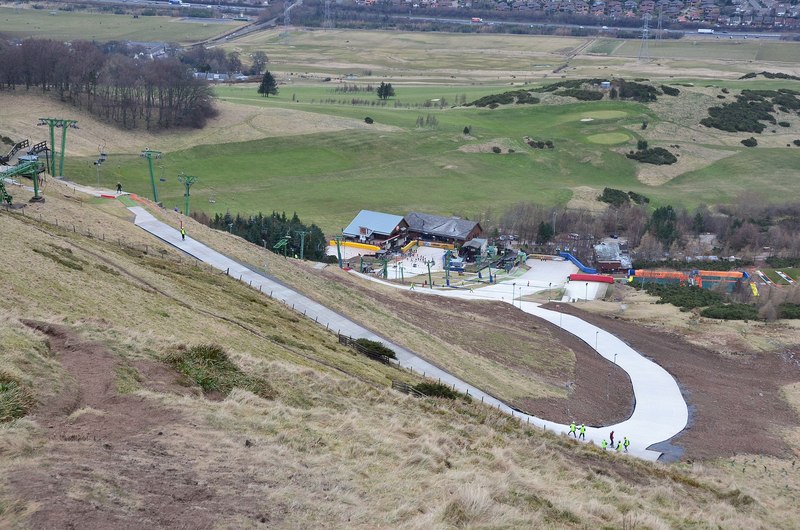
Midlothian Snowsports Centre (Hillend Dry Slope) is a mapped downhill ski area in GB. Forecasts cover three real lift-station locations from approximately 239 to 343 metres. Elevations are terrain-model estimates.
Data: OpenSkiData / OpenSkiMap, OpenStreetMap contributors (ODbL), Skimap.org, Who's On First, Mapterhorn.
Midlothian Snowsports Centre (Hillend Dry Slope) - Middle lift station
ECMWF · Model run: Next update expected:
Day Time (UTC) Temp. (°C) Humidity (%) Wind (km/h) Wind (knots) Wind (Bft) Direction Precip. (mm) Snow (cm) Pressure (hPa) Freezing (m) Conditions | Thursday, 05/11 06:00 5.9 87 18 10 3B E — — 1034 1874 Overcast 99% cloud 09:00 6.8 86 23 12 4B E 0.07 0 1034 2064 Overcast 97% cloud 12:00 7.6 82 27 15 4B E 0.05 0 1034 2219 Overcast 100% cloud 15:00 7.5 85 24 13 4B E 0.13 0 1032 2083 Overcast 100% cloud 18:00 7.3 91 25 13 4B E 0.06 0 1031 1817 Overcast 100% cloud 21:00 7.5 89 22 12 4B E 0.06 0 1031 1891 Overcast 100% cloud Friday, 06/11 00:00 7.3 90 20 11 3B E 0.05 0 1030 1613 Overcast 94% cloud 03:00 7.3 90 18 10 3B E 0.01 0 1029 1653 Overcast 98% cloud 06:00 7.2 93 18 9 3B E 0.11 0 1028 1471 Overcast 92% cloud 09:00 7.5 91 19 10 3B E 0.02 0 1029 1361 Overcast 99% cloud 12:00 8.1 86 19 10 3B E 0.22 0 1028 1390 Overcast 97% cloud 15:00 8 84 16 8 3B E 0.06 0 1027 1419 Overcast 100% cloud 18:00 7.1 87 13 7 3B E 0 0 1027 1838 Overcast 100% cloud 21:00 6.4 89 11 6 2B E 0 0 1027 1802 Overcast 100% cloud Saturday, 07/11 00:00 6.3 91 9 5 2B E 0.06 0 1026 1352 Overcast 100% cloud 03:00 6.3 91 10 5 2B NE 0.06 0 1025 1348 Overcast 100% cloud 06:00 6.2 93 11 6 2B NE 0.06 0 1025 1399 Overcast 100% cloud 09:00 6.7 93 10 5 2B NE 0.06 0 1025 1399 Overcast 100% cloud 12:00 7.6 91 9 5 2B E 0.12 0 1024 1438 Overcast 100% cloud 15:00 7.8 90 10 6 2B E 0.20 0 1023 1448 Overcast 98% cloud 18:00 6.7 93 10 5 2B E 0.18 0 1022 1398 Overcast 97% cloud 21:00 6.3 95 7 4 2B E 0.24 0 1022 1383 Overcast 100% cloud Sunday, 08/11 00:00 6 95 6 3 2B NE 0.20 0 1022 1385 Overcast 99% cloud 03:00 6.2 95 7 4 2B NE 0.28 0 1020 1351 Overcast 99% cloud 06:00 5.9 96 9 5 2B NE 0.45 0 1020 1356 Overcast 99% cloud 09:00 6.1 95 7 4 2B NE 0.24 0 1020 1342 Overcast 98% cloud 12:00 6.8 92 6 3 2B NE 0.09 0 1020 1314 Overcast 100% cloud 15:00 6.7 91 7 4 2B N 0.23 0 1019 1322 Overcast 89% cloud 18:00 5.8 93 5 3 1B N 0.42 0 1020 1272 Cloudy 80% cloud 21:00 4.8 94 5 3 1B NE 0.16 0 1020 1244 Cloudy 75% cloud Monday, 09/11 00:00 4.4 97 4 2 1B NE 0.13 0 1020 1181 Overcast 81% cloud 03:00 4.2 96 4 2 1B N 0.01 0 1020 1110 Overcast 97% cloud 06:00 3.7 96 4 2 1B N 0 0 1020 1138 Overcast 98% cloud 09:00 3.6 97 4 2 1B N 0 0 1021 1086 Overcast 100% cloud 12:00 4.7 92 3 2 1B NE 0 0 1020 1162 Overcast 88% cloud 15:00 5.2 89 6 3 2B NE 0 0 1019 1295 Cloudy 57% cloud 18:00 3.7 95 7 4 2B E 0.01 0 1019 1837 Cloudy 57% cloud 21:00 2.7 97 7 4 2B E 0 0 1019 1849 Overcast 93% cloud Tuesday, 10/11 00:00 2.7 97 6 3 2B SE 0.01 0 1018 1801 Overcast 99% cloud 03:00 2.1 95 8 4 2B SE 0 0 1016 2149 Overcast 99% cloud 06:00 1.9 93 8 4 2B SE 0 0 1016 1856 Overcast 93% cloud 09:00 2.6 95 11 6 2B SE 0 0 1016 2033 Cloudy 69% cloud 12:00 5.5 88 12 6 2B SE 0 0 1014 2193 Partly cloudy 36% cloud 15:00 6.6 83 12 6 2B SE 0 0 1013 2183 Partly cloudy 34% cloud 18:00 4.6 87 14 7 3B SE 0 0 1012 2272 Clear 4% cloud 21:00 3.7 87 12 7 3B SE 0 0 1011 2334 Clear 1% cloud Wednesday, 11/11 00:00 4.1 81 10 5 2B SE 0 0 1009 2321 Overcast 99% cloud 03:00 5.2 79 9 5 2B SE 0 0 1007 2278 Overcast 100% cloud 06:00 5.4 86 9 5 2B SE 0.30 0 1005 2265 Overcast 100% cloud |
|---|
Forecast notes
Forecast table times: UTC.
Coordinates: 55.8853895°N, -3.2119135°E · Requested elevation: 298 m. Model terrain: 149 m. Terrain and 1000/925/850/700 hPa profiles are used for height estimates.
These are altitude estimates, not a simulation of local mountain terrain. Precipitation, cloud and sea-level pressure use horizontal interpolation only.
Precipitation includes rain and snow water equivalent: preceding 3 hours through day 6, then 6 hours (see cell tooltip). Snow (cm) estimates fresh snowfall from precipitation and temperature using the GFS conversion; it is not snow depth on the ground. Freezing (m) uses additional 600/500 hPa temperatures when available and estimates the lowest resolved 0°C crossing above sea level. When all sampled levels are warm, the upper profile limit is shown (see tooltip). < marks an entirely cold sampled profile and its lower height limit. No extrapolation is used.
Source: ECMWF · CC BY 4.0 · Processed by Snow Report.
Midlothian Snowsports Centre (Hillend Dry Slope) - Top lift station
ECMWF · Model run: Next update expected:
Day Time (UTC) Temp. (°C) Humidity (%) Wind (km/h) Wind (knots) Wind (Bft) Direction Precip. (mm) Snow (cm) Pressure (hPa) Freezing (m) Conditions | Thursday, 05/11 06:00 5.6 88 19 10 3B E — — 1034 1875 Overcast 99% cloud 09:00 6.4 86 24 13 4B E 0.07 0 1034 2065 Overcast 97% cloud 12:00 7.2 83 28 15 4B E 0.05 0 1034 2219 Overcast 100% cloud 15:00 7.2 85 25 14 4B E 0.13 0 1032 2082 Overcast 100% cloud 18:00 6.9 91 26 14 4B E 0.06 0 1031 1816 Overcast 100% cloud 21:00 7.1 89 24 13 4B E 0.06 0 1031 1891 Overcast 100% cloud Friday, 06/11 00:00 7 90 21 11 4B E 0.05 0 1030 1613 Overcast 94% cloud 03:00 7 91 19 10 3B E 0.01 0 1029 1653 Overcast 98% cloud 06:00 6.9 93 19 10 3B E 0.11 0 1028 1471 Overcast 92% cloud 09:00 7.1 92 20 11 4B E 0.02 0 1029 1361 Overcast 99% cloud 12:00 7.8 87 20 11 3B E 0.22 0 1028 1390 Overcast 97% cloud 15:00 7.6 84 16 9 3B E 0.06 0 1027 1419 Overcast 100% cloud 18:00 6.8 88 14 8 3B E 0 0 1027 1838 Overcast 100% cloud 21:00 6.1 89 12 6 2B E 0 0 1027 1802 Overcast 100% cloud Saturday, 07/11 00:00 6 91 10 5 2B E 0.06 0 1026 1352 Overcast 100% cloud 03:00 6 91 11 6 2B NE 0.06 0 1025 1348 Overcast 100% cloud 06:00 6 94 12 6 2B NE 0.06 0 1025 1399 Overcast 100% cloud 09:00 6.4 93 11 6 2B NE 0.06 0 1025 1399 Overcast 100% cloud 12:00 7.3 91 9 5 2B E 0.12 0 1024 1438 Overcast 100% cloud 15:00 7.5 90 11 6 2B E 0.20 0 1023 1447 Overcast 98% cloud 18:00 6.5 93 11 6 2B E 0.18 0 1022 1398 Overcast 97% cloud 21:00 6.1 94 8 4 2B E 0.24 0 1022 1383 Overcast 100% cloud Sunday, 08/11 00:00 5.8 95 7 4 2B NE 0.20 0 1022 1384 Overcast 99% cloud 03:00 5.9 95 7 4 2B NE 0.28 0 1020 1351 Overcast 99% cloud 06:00 5.6 96 9 5 2B NE 0.45 0 1020 1356 Overcast 99% cloud 09:00 5.9 95 7 4 2B NE 0.24 0 1020 1342 Overcast 98% cloud 12:00 6.5 92 7 4 2B NE 0.09 0 1020 1314 Overcast 100% cloud 15:00 6.4 91 7 4 2B N 0.23 0 1019 1322 Overcast 89% cloud 18:00 5.6 93 6 3 2B N 0.41 0 1020 1272 Cloudy 80% cloud 21:00 4.6 94 6 3 2B NE 0.16 0 1020 1244 Cloudy 75% cloud Monday, 09/11 00:00 4.2 97 5 3 1B NE 0.13 0 1020 1181 Overcast 81% cloud 03:00 4 96 4 2 1B N 0.01 0 1020 1110 Overcast 97% cloud 06:00 3.5 95 5 3 1B NE 0 0 1020 1138 Overcast 98% cloud 09:00 3.4 97 5 3 1B NE 0 0 1021 1086 Overcast 100% cloud 12:00 4.5 91 4 2 1B NE 0 0 1020 1162 Overcast 88% cloud 15:00 4.9 90 7 4 2B NE 0 0 1019 1296 Cloudy 57% cloud 18:00 3.5 95 9 5 2B E 0.01 0 1019 1838 Cloudy 58% cloud 21:00 2.7 97 9 5 2B E 0 0 1019 1849 Overcast 93% cloud Tuesday, 10/11 00:00 2.7 96 8 4 2B SE 0.01 0 1018 1803 Overcast 99% cloud 03:00 2.1 95 9 5 2B SE 0 0 1016 2150 Overcast 99% cloud 06:00 1.9 92 10 5 2B SE 0 0 1016 1856 Overcast 93% cloud 09:00 2.6 94 13 7 3B SE 0 0 1016 2034 Cloudy 68% cloud 12:00 5.2 88 13 7 3B SE 0 0 1014 2193 Partly cloudy 36% cloud 15:00 6.2 84 14 7 3B SE 0 0 1013 2184 Partly cloudy 34% cloud 18:00 4.4 86 15 8 3B SE 0 0 1012 2273 Clear 4% cloud 21:00 3.7 85 14 8 3B SE 0 0 1011 2335 Clear 1% cloud Wednesday, 11/11 00:00 4.3 77 11 6 2B SE 0 0 1009 2322 Overcast 99% cloud 03:00 5.3 76 10 5 2B SE 0 0 1007 2279 Overcast 100% cloud 06:00 5.5 84 10 5 2B SE 0.30 0 1005 2266 Overcast 100% cloud |
|---|
Forecast notes
Forecast table times: UTC.
Coordinates: 55.8844827°N, -3.2122764°E · Requested elevation: 343 m. Model terrain: 150 m. Terrain and 1000/925/850/700 hPa profiles are used for height estimates.
These are altitude estimates, not a simulation of local mountain terrain. Precipitation, cloud and sea-level pressure use horizontal interpolation only.
Precipitation includes rain and snow water equivalent: preceding 3 hours through day 6, then 6 hours (see cell tooltip). Snow (cm) estimates fresh snowfall from precipitation and temperature using the GFS conversion; it is not snow depth on the ground. Freezing (m) uses additional 600/500 hPa temperatures when available and estimates the lowest resolved 0°C crossing above sea level. When all sampled levels are warm, the upper profile limit is shown (see tooltip). < marks an entirely cold sampled profile and its lower height limit. No extrapolation is used.