Camera 1
Press play to connect.

Each colour starts at the value shown. Wind colours match across all three units. Dry cells stay neutral. Colours describe the displayed values, not official weather warnings.
ECMWF · Model run: Next update expected:
Day Time (UTC) Temp. (°C) Humidity (%) Wind (km/h) Wind (knots) Wind (Bft) Direction Precip. (mm) Snow (cm) Pressure (hPa) Freezing (m) Conditions | Thursday, 05/11 06:00 4.8 90 13 7 3B E — — 1024 2668 Overcast 97% cloud  09:00 4.9 89 14 7 3B E 0.21 0 1024 2614 Cloudy 71% cloud  12:00 4.7 93 11 6 2B E 2.0 0 1024 2524 Cloudy 76% cloud 15:00 4.3 93 7 4 2B NE 0.94 0 1024 2537 Overcast 87% cloud 18:00 3.6 94 8 5 2B NE 0.23 0 1025 2448 Overcast 96% cloud 21:00 3.3 87 10 5 2B NE 0.05 0 1025 2394 Overcast 94% cloud Friday, 06/11 00:00 3 85 10 5 2B NE 0 0 1025 2338 Overcast 96% cloud 03:00 2.6 81 14 7 3B NE 0 0 1024 2336 Overcast 97% cloud 06:00 2.5 82 13 7 3B N 0.01 0 1024 2454 Overcast 93% cloud 09:00 3.3 77 9 5 2B N 0.00 0 1022 2637 Partly cloudy 25% cloud  12:00 4.6 70 10 5 2B NW 0 0 1020 2757 Clear 15% cloud  15:00 4.7 72 11 6 2B NW 0 0 1020 2770 Clear 10% cloud 18:00 4.2 64 13 7 3B NW 0 0 1021 2807 Clear 2% cloud 21:00 4.5 66 16 9 3B N 0 0 1021 2851 Clear 1% cloud Saturday, 07/11 00:00 4.3 65 13 7 3B N 0 0 1022 2805 Clear 3% cloud 03:00 4 65 10 5 2B N 0 0 1021 2755 Clear 3% cloud 06:00 3.5 68 8 4 2B NE 0 0 1023 2691 Clear 10% cloud 09:00 3.8 74 7 4 2B E 0 0 1023 2757 Cloudy 63% cloud 12:00 4.3 81 4 2 1B NE 1.3 0 1022 2739 Overcast 89% cloud 15:00 3.8 88 2 1 1B N 0.47 0 1023 2682 Overcast 93% cloud 18:00 3.1 93 2 1 1B N 0 0 1025 2575 Overcast 90% cloud 21:00 2.9 91 6 3 2B NE 0 0 1027 2442 Overcast 95% cloud Sunday, 08/11 00:00 2.5 82 9 5 2B NE 0 0 1028 2367 Overcast 98% cloud 03:00 1.8 86 15 8 3B NE 0 0 1028 2232 Overcast 98% cloud 06:00 1.4 82 16 8 3B NE 0 0 1029 2116 Overcast 96% cloud 09:00 1.9 84 11 6 2B NE 0 0 1029 2209 Partly cloudy 49% cloud 12:00 3.2 81 7 4 2B NE 0 0 1027 2414 Partly cloudy 46% cloud 15:00 3.1 88 4 2 1B NE 0 0 1029 2466 Cloudy 78% cloud 18:00 3.7 75 9 5 2B N 0 0 1030 2555 Cloudy 74% cloud 21:00 4.2 63 7 4 2B N 0 0 1029 2602 Overcast 93% cloud Monday, 09/11 00:00 4.7 58 5 3 1B NE 0 0 1028 2648 Cloudy 79% cloud 03:00 4.8 57 1 1 0B N 0 0 1028 2672 Overcast 96% cloud 06:00 5.1 59 3 2 1B W 0.08 0 1028 2642 Overcast 97% cloud 09:00 5.3 71 10 5 2B SW 0.03 0 1028 2641 Overcast 87% cloud 12:00 5.3 85 12 7 3B SW 0.33 0 1026 2680 Overcast 100% cloud 15:00 5 93 16 9 3B SW 0.27 0 1026 2650 Overcast 99% cloud 18:00 5.1 94 17 9 3B W 0.10 0 1027 2683 Overcast 97% cloud 21:00 5.5 94 18 10 3B SW 0.22 0 1027 2715 Overcast 100% cloud Tuesday, 10/11 00:00 5.6 92 22 12 4B SW 0.41 0 1026 2744 Overcast 100% cloud 03:00 5.4 96 25 14 4B SW 0.24 0 1025 2768 Overcast 100% cloud 06:00 5.6 97 23 12 4B W 0.35 0 1025 2848 Overcast 100% cloud 09:00 5.9 95 19 10 3B W 0.29 0 1025 2999 Overcast 99% cloud 12:00 6.8 86 18 10 3B W 0.90 0 1023 3090 Overcast 82% cloud 15:00 6.6 93 20 11 3B W 0.75 0 1022 3115 Cloudy 72% cloud 18:00 6.6 95 20 11 4B W 0 0 1023 3124 Overcast 100% cloud 21:00 6.9 97 23 12 4B W 0.40 0 1022 3123 Overcast 100% cloud Wednesday, 11/11 00:00 6.8 97 24 13 4B W 0.05 0 1022 3118 Overcast 100% cloud 03:00 6.9 95 25 13 4B W 0.00 0 1020 3106 Overcast 100% cloud 06:00 6.9 96 23 13 4B W 0.05 0 1021 2952 Overcast 100% cloud |
|---|
Forecast table times: UTC.
Coordinates: 38.00698°N, 22.19639°E · Requested elevation: 1705 m. Model terrain: 1266 m. Terrain and 1000/925/850/700 hPa profiles are used for height estimates.
These are altitude estimates, not a simulation of local mountain terrain. Precipitation, cloud and sea-level pressure use horizontal interpolation only.
Precipitation includes rain and snow water equivalent: preceding 3 hours through day 6, then 6 hours (see cell tooltip). Snow (cm) estimates fresh snowfall from precipitation and temperature using the GFS conversion; it is not snow depth on the ground. Freezing (m) uses additional 600/500 hPa temperatures when available and estimates the lowest resolved 0°C crossing above sea level. When all sampled levels are warm, the upper profile limit is shown (see tooltip). < marks an entirely cold sampled profile and its lower height limit. No extrapolation is used.
Source: ECMWF · CC BY 4.0 · Processed by Snow Report.
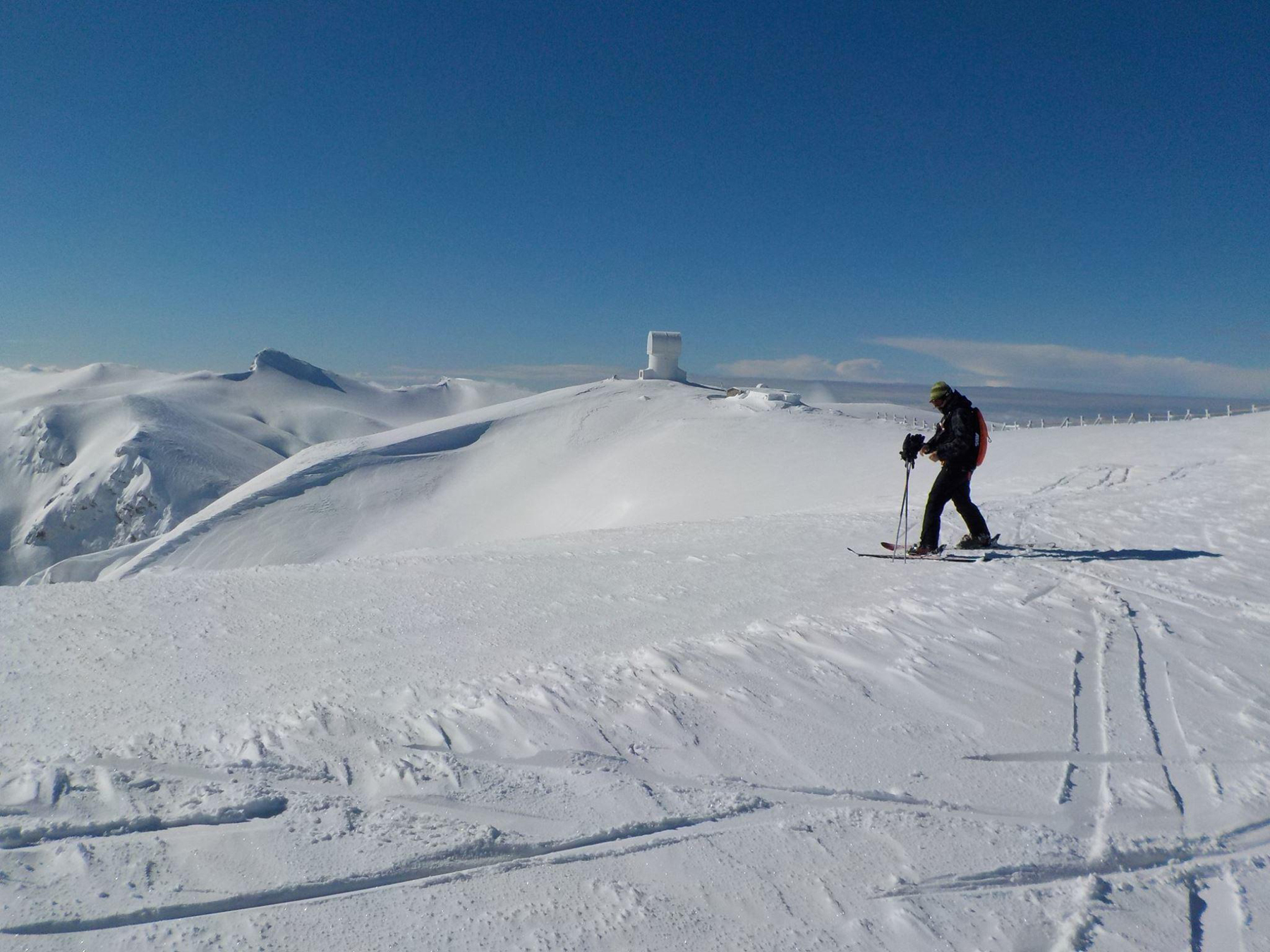
Kalavrita’s ski area is on Mount Helmos in the northern Peloponnese. The forecasts here follow three reference points: the base at 1,705 m, Vatheia Laka at 1,855 m and Styga Top at 2,315 m. The base and the highest point are 610 metres apart vertically, so choose the elevation relevant to your visit.
If precipitation coincides with temperatures near freezing, compare all three points and open the detailed intervals for the hours you will be there. A daily total can hide a change from rain to snow or a dry part of the day. The freezing level is useful context, but is not an exact boundary between rain and snow.
For the upper mountain, examine wind and gusts alongside temperature and snowfall. Differences between GFS, ECMWF and ICON-EU at the same time and elevation show uncertainty; no model confirms lift operation. Check the dated Kalavrita SnowReport bulletin, webcams and access information before travelling. Predicted fresh snow must not be read as measured piste depth.
Forecast points and guidance reviewed 4 November 2026. Current bulletin and webcams: SnowReport.gr.
Swipe to see all 5 places to stay →
 Filoxenia Hotel & Spa
Kalavrita
Drive to ski centre: ≈ 14.9 km · 23 min
View on Booking.com ↗
 Anerada Hotel
Kalavrita
Drive to ski centre: ≈ 13.0 km · 21 min
View on Booking.com ↗
 Kalavrita Canyon Hotel & Spa
Kalavrita
Drive to ski centre: ≈ 14.7 km · 23 min
View on Booking.com ↗
 Anesis Hotel
Kalavrita
Drive to ski centre: ≈ 14.5 km · 22 min
View on Booking.com ↗
 Ahilion Hotel
Kalavrita
Drive to ski centre: ≈ 14.5 km · 22 min
View on Booking.com ↗
Press play to connect.
Press play to connect.
ECMWF · Model run: Next update expected:
Day Time (UTC) Temp. (°C) Humidity (%) Wind (km/h) Wind (knots) Wind (Bft) Direction Precip. (mm) Snow (cm) Pressure (hPa) Freezing (m) Conditions | Thursday, 05/11 06:00 4 86 12 7 2B NE — — 1024 2671 Overcast 99% cloud 09:00 4.1 87 12 6 2B E 0.21 0 1024 2616 Cloudy 71% cloud 12:00 3.8 93 9 5 2B NE 2.1 0 1024 2526 Cloudy 77% cloud 15:00 3.5 90 6 3 1B NE 0.96 0 1024 2539 Overcast 88% cloud 18:00 2.9 91 8 4 2B NE 0.24 0 1025 2450 Overcast 98% cloud 21:00 2.6 85 10 5 2B NE 0.05 0 1025 2396 Overcast 96% cloud Friday, 06/11 00:00 2.3 83 11 6 2B N 0 0 1025 2340 Overcast 98% cloud 03:00 2 78 15 8 3B N 0 0 1024 2338 Overcast 98% cloud 06:00 2 77 15 8 3B N 0 0 1024 2457 Overcast 93% cloud 09:00 2.8 72 11 6 2B N 0 0 1022 2639 Partly cloudy 25% cloud 12:00 3.9 66 12 7 2B NW 0 0 1020 2758 Clear 16% cloud 15:00 4 68 14 7 3B NW 0.00 0 1020 2770 Clear 10% cloud 18:00 3.7 60 15 8 3B N 0 0 1021 2807 Clear 2% cloud 21:00 3.9 62 17 9 3B N 0 0 1022 2853 Clear 0% cloud Saturday, 07/11 00:00 3.7 61 14 8 3B N 0 0 1022 2807 Clear 2% cloud 03:00 3.4 61 11 6 2B N 0 0 1021 2756 Clear 2% cloud 06:00 3 64 8 4 2B NE 0 0 1023 2692 Clear 10% cloud 09:00 3.2 70 6 3 2B NE 0 0 1023 2758 Cloudy 62% cloud 12:00 3.7 76 5 3 1B N 1.3 0 1022 2742 Overcast 89% cloud 15:00 3.3 84 5 3 1B NW 0.47 0 1023 2683 Overcast 95% cloud 18:00 2.6 88 4 2 1B N 0.00 0 1025 2577 Overcast 91% cloud 21:00 2.3 87 6 3 2B N 0 0 1027 2444 Overcast 96% cloud Sunday, 08/11 00:00 1.9 79 8 4 2B NE 0 0 1028 2371 Overcast 100% cloud 03:00 1.3 84 12 7 3B NE 0 0 1028 2236 Overcast 99% cloud 06:00 0.9 81 13 7 3B NE 0 0 1029 2122 Overcast 97% cloud 09:00 1.4 83 9 5 2B NE 0 0 1029 2212 Partly cloudy 49% cloud 12:00 2.5 79 7 4 2B N 0 0 1027 2418 Partly cloudy 46% cloud 15:00 2.5 85 6 3 2B N 0 0 1028 2468 Cloudy 80% cloud 18:00 3.1 73 11 6 2B N 0 0 1030 2557 Cloudy 75% cloud 21:00 3.5 63 8 5 2B N 0 0 1029 2604 Overcast 93% cloud Monday, 09/11 00:00 3.9 60 6 3 2B N 0 0 1028 2650 Cloudy 79% cloud 03:00 4.1 59 3 1 1B NW 0 0 1028 2673 Overcast 96% cloud 06:00 4.3 62 4 2 1B W 0.08 0 1028 2642 Overcast 97% cloud 09:00 4.4 73 11 6 2B W 0.03 0 1028 2641 Overcast 86% cloud 12:00 4.5 86 14 7 3B SW 0.34 0 1026 2682 Overcast 100% cloud 15:00 4.2 93 18 10 3B W 0.27 0 1026 2650 Overcast 99% cloud 18:00 4.3 94 19 10 3B W 0.11 0 1027 2684 Overcast 97% cloud 21:00 4.7 95 20 11 4B W 0.23 0 1027 2715 Overcast 100% cloud Tuesday, 10/11 00:00 4.8 93 24 13 4B W 0.42 0 1026 2745 Overcast 100% cloud 03:00 4.6 96 27 14 4B W 0.24 0 1025 2769 Overcast 100% cloud 06:00 4.9 94 24 13 4B W 0.35 0 1025 2848 Overcast 100% cloud 09:00 5.2 92 20 11 3B W 0.30 0 1025 2999 Overcast 99% cloud 12:00 6.1 83 20 11 3B W 0.92 0 1023 3088 Overcast 82% cloud 15:00 5.9 89 21 11 4B W 0.76 0 1023 3112 Cloudy 72% cloud 18:00 5.9 94 22 12 4B W 0.00 0 1023 3124 Overcast 100% cloud 21:00 6.2 94 24 13 4B W 0.41 0 1023 3123 Overcast 100% cloud Wednesday, 11/11 00:00 6.1 94 25 13 4B W 0.05 0 1022 3118 Overcast 100% cloud 03:00 6.1 91 26 14 4B W 0.00 0 1020 3106 Overcast 100% cloud 06:00 6 94 25 13 4B W 0.05 0 1021 2952 Overcast 100% cloud |
|---|
Forecast table times: UTC.
Coordinates: 37.9996°N, 22.19396°E · Requested elevation: 1855 m. Model terrain: 1297 m. Terrain and 1000/925/850/700 hPa profiles are used for height estimates.
These are altitude estimates, not a simulation of local mountain terrain. Precipitation, cloud and sea-level pressure use horizontal interpolation only.
Precipitation includes rain and snow water equivalent: preceding 3 hours through day 6, then 6 hours (see cell tooltip). Snow (cm) estimates fresh snowfall from precipitation and temperature using the GFS conversion; it is not snow depth on the ground. Freezing (m) uses additional 600/500 hPa temperatures when available and estimates the lowest resolved 0°C crossing above sea level. When all sampled levels are warm, the upper profile limit is shown (see tooltip). < marks an entirely cold sampled profile and its lower height limit. No extrapolation is used.
Source: ECMWF · CC BY 4.0 · Processed by Snow Report.
ECMWF · Model run: Next update expected:
Day Time (UTC) Temp. (°C) Humidity (%) Wind (km/h) Wind (knots) Wind (Bft) Direction Precip. (mm) Snow (cm) Pressure (hPa) Freezing (m) Conditions | Thursday, 05/11 06:00 1.8 72 11 6 2B NE — — 1024 2673 Overcast 99% cloud 09:00 1.6 79 8 4 2B NE 0.21 0 1024 2618 Cloudy 70% cloud 12:00 1.2 92 5 3 1B N 2.0 0 1024 2527 Cloudy 76% cloud 15:00 1.2 79 8 4 2B NW 0.93 0 1024 2539 Overcast 87% cloud 18:00 0.7 81 11 6 2B N 0.23 0 1025 2452 Overcast 96% cloud 21:00 0.4 74 14 7 3B N 0.05 0 1025 2399 Overcast 96% cloud Friday, 06/11 00:00 0.1 76 17 9 3B N 0 0 1025 2341 Overcast 97% cloud 03:00 0.1 69 22 12 4B N 0 0 1024 2340 Overcast 98% cloud 06:00 0.5 58 20 11 4B N 0 0 1024 2458 Overcast 92% cloud 09:00 1.2 54 18 10 3B N 0 0 1022 2639 Partly cloudy 25% cloud 12:00 1.9 51 20 11 4B NW 0 0 1020 2761 Clear 16% cloud 15:00 2 52 22 12 4B NW 0.00 0 1020 2774 Clear 10% cloud 18:00 1.9 47 22 12 4B N 0 0 1021 2808 Clear 4% cloud 21:00 2.1 48 21 11 4B N 0 0 1022 2856 Clear 4% cloud Saturday, 07/11 00:00 1.9 47 18 10 3B N 0 0 1022 2808 Clear 5% cloud 03:00 1.7 47 15 8 3B N 0 0 1021 2757 Clear 4% cloud 06:00 1.4 50 11 6 2B N 0 0 1023 2692 Clear 12% cloud 09:00 1.6 53 10 5 2B N 0 0 1023 2761 Cloudy 61% cloud 12:00 1.8 59 12 7 3B N 1.3 0 1022 2746 Overcast 87% cloud 15:00 1.5 67 13 7 3B NW 0.46 0 1023 2689 Overcast 94% cloud 18:00 0.9 71 11 6 2B NW 0.00 0 1025 2579 Overcast 90% cloud 21:00 0.5 71 11 6 2B N 0 0 1027 2446 Overcast 93% cloud Sunday, 08/11 00:00 0.2 68 10 5 2B N 0 0 1028 2372 Overcast 98% cloud 03:00 -0.3 74 12 6 2B N 0 0 1028 2238 Overcast 98% cloud 06:00 -0.7 78 12 7 2B N 0 0 1029 2124 Overcast 96% cloud 09:00 -0.4 75 13 7 3B NW 0 0 1029 2213 Partly cloudy 48% cloud 12:00 0.4 69 15 8 3B NW 0 0 1027 2416 Partly cloudy 45% cloud 15:00 0.6 73 17 9 3B NW 0 0 1029 2468 Cloudy 78% cloud 18:00 1.1 65 19 10 3B NW 0 0 1030 2557 Cloudy 74% cloud 21:00 1.4 62 16 9 3B NW 0 0 1029 2606 Overcast 92% cloud Monday, 09/11 00:00 1.7 65 12 6 2B NW 0 0 1028 2651 Cloudy 78% cloud 03:00 1.8 66 8 4 2B NW 0 0 1028 2673 Overcast 94% cloud 06:00 1.8 72 8 4 2B W 0.07 0 1028 2644 Overcast 97% cloud 09:00 1.8 82 15 8 3B W 0.02 0 1028 2641 Overcast 87% cloud 12:00 2 90 19 10 3B W 0.33 0 1026 2683 Overcast 98% cloud 15:00 1.8 93 25 13 4B W 0.26 0 1026 2652 Overcast 99% cloud 18:00 1.9 95 25 14 4B W 0.10 0 1027 2687 Overcast 97% cloud 21:00 2.2 97 26 14 4B W 0.22 0 1027 2717 Overcast 100% cloud Tuesday, 10/11 00:00 2.3 94 31 17 5B W 0.41 0 1026 2745 Overcast 100% cloud 03:00 2.3 93 32 17 5B W 0.26 0 1025 2770 Overcast 100% cloud 06:00 2.6 85 29 16 5B W 0.33 0 1025 2849 Overcast 100% cloud 09:00 3.1 78 24 13 4B W 0.28 0 1025 2999 Overcast 99% cloud 12:00 3.8 72 24 13 4B W 0.93 0 1023 3085 Overcast 82% cloud 15:00 3.7 75 26 14 4B W 0.75 0 1023 3113 Cloudy 72% cloud 18:00 3.8 87 27 15 4B W 0.00 0 1023 3124 Overcast 100% cloud 21:00 4 83 29 15 4B W 0.38 0 1023 3123 Overcast 100% cloud Wednesday, 11/11 00:00 4 84 27 15 4B W 0.05 0 1022 3118 Overcast 100% cloud 03:00 3.9 77 29 16 5B W 0.00 0 1020 3106 Overcast 100% cloud 06:00 3.5 87 30 16 5B W 0.05 0 1021 2953 Overcast 100% cloud |
|---|
Forecast table times: UTC.
Coordinates: 37.98777°N, 22.197806°E · Requested elevation: 2315 m. Model terrain: 1282 m. Terrain and 1000/925/850/700 hPa profiles are used for height estimates.
These are altitude estimates, not a simulation of local mountain terrain. Precipitation, cloud and sea-level pressure use horizontal interpolation only.
Precipitation includes rain and snow water equivalent: preceding 3 hours through day 6, then 6 hours (see cell tooltip). Snow (cm) estimates fresh snowfall from precipitation and temperature using the GFS conversion; it is not snow depth on the ground. Freezing (m) uses additional 600/500 hPa temperatures when available and estimates the lowest resolved 0°C crossing above sea level. When all sampled levels are warm, the upper profile limit is shown (see tooltip). < marks an entirely cold sampled profile and its lower height limit. No extrapolation is used.