Worldwide Ski Resort Forecasts

More
Colour guide Temperature · Wind · Rain · Snow
Each colour starts at the value shown. Wind colours match across all three units. Dry cells stay neutral. Colours describe the displayed values, not official weather warnings.
Bromley Mountain Ski Resort;Bromley Mountain - Low lift station
ECMWF · Model run: Next update expected:
Day Time (UTC) Temp. (°C) Humidity (%) Wind (km/h) Wind (knots) Wind (Bft) Direction Precip. (mm) Snow (cm) Pressure (hPa) Freezing (m) Conditions | Thursday, 05/11 06:00 12.2 76 14 8 3B SW — — 1013 3107 Clear 6% cloud  09:00 12 87 21 11 4B SW 0 0 1013 3091 Partly cloudy 26% cloud  12:00 13 97 18 10 3B SW 0.11 0 1012 3084 Overcast 100% cloud  15:00 15.7 98 21 11 4B SW 2.4 0 1011 3076 Overcast 100% cloud 18:00 16.3 98 18 10 3B SW 3.6 0 1009 3063 Overcast 98% cloud 21:00 16.4 93 17 9 3B SW 1.0 0 1009 3059 Cloudy 62% cloud  Friday, 06/11 00:00 15.5 97 22 12 4B SW 0.31 0 1010 3063 Cloudy 53% cloud 03:00 14.9 99 17 9 3B SW 0.61 0 1010 3061 Overcast 98% cloud 06:00 14.8 99 14 8 3B W 1.2 0 1010 3054 Overcast 100% cloud 09:00 12.5 99 7 4 2B W 0.40 0 1012 3051 Overcast 86% cloud 12:00 10.5 97 4 2 1B W 0.03 0 1013 3056 Overcast 95% cloud 15:00 14 76 2 1 1B W 0 0 1013 3053 Cloudy 59% cloud 18:00 17.1 54 6 3 2B W 0 0 1011 3041 Clear 15% cloud 21:00 14.7 68 8 4 2B NW 0 0 1011 2988 Partly cloudy 34% cloud Saturday, 07/11 00:00 10.7 79 6 3 2B N 0 0 1012 3039 Cloudy 74% cloud 03:00 10.3 79 12 7 2B NE 0 0 1012 2981 Overcast 100% cloud 06:00 9.3 85 10 6 2B E 0 0 1011 2735 Partly cloudy 38% cloud 09:00 8.7 91 8 4 2B E 0.01 0 1010 2845 Partly cloudy 34% cloud 12:00 8.6 93 11 6 2B E 0.21 0 1011 2716 Overcast 80% cloud 15:00 9.8 87 10 6 2B E 0.55 0 1011 2654 Overcast 100% cloud 18:00 10.8 83 9 5 2B E 0.44 0 1008 2619 Overcast 100% cloud 21:00 9.8 94 2 1 1B SE 0.67 0 1008 2429 Overcast 100% cloud Sunday, 08/11 00:00 8.4 98 4 2 1B E 2.7 0 1008 2230 Overcast 100% cloud 03:00 6.8 100 1 0 0B SE 3.7 0 1007 2015 Overcast 100% cloud 06:00 5.2 100 8 4 2B NW 4.4 0 1007 1847 Overcast 100% cloud 09:00 3 100 16 9 3B NW 3.2 0 1008 1656 Overcast 100% cloud 12:00 2.7 98 16 8 3B NW 0.47 0 1009 1378 Overcast 100% cloud 15:00 5 85 19 10 3B W 0.01 0 1009 1381 Overcast 100% cloud 18:00 6.8 80 22 12 4B W 0.10 0 1007 1494 Overcast 99% cloud 21:00 6.8 69 22 12 4B W 0.10 0 1006 1492 Clear 7% cloud Monday, 09/11 00:00 4.7 73 16 8 3B W 0 0 1005 1537 Overcast 97% cloud 03:00 4.8 87 18 10 3B W 0.26 0 1005 1380 Overcast 99% cloud 06:00 4.4 99 21 11 4B W 0.93 0 1004 1406 Overcast 100% cloud 09:00 4.3 98 21 11 4B W 1.1 0 1004 1305 Overcast 96% cloud 12:00 3.9 98 21 11 4B W 0.67 0 1005 1197 Overcast 100% cloud 15:00 4 93 19 10 3B W 0.98 0 1007 1128 Overcast 98% cloud 18:00 4.7 84 20 11 3B NW 0.91 0 1007 1153 Overcast 93% cloud 21:00 4.9 68 22 12 4B NW 0.04 0 1009 1122 Overcast 99% cloud Tuesday, 10/11 00:00 3.8 71 22 12 4B W 0.10 0 1011 1034 Overcast 96% cloud 03:00 2.9 76 19 10 3B W 0 0 1012 996 Overcast 85% cloud 06:00 2.7 80 19 10 3B W 0 0 1013 1026 Overcast 91% cloud 09:00 2.3 82 16 9 3B W 0 0 1013 1183 Overcast 88% cloud 12:00 2.4 85 15 8 3B W 0 0 1013 1552 Overcast 98% cloud 15:00 4.8 78 19 10 3B W 0 0 1012 1435 Overcast 100% cloud 18:00 6.8 68 17 9 3B W 0 0 1009 1819 Overcast 82% cloud 21:00 7.1 73 16 9 3B SW 0.05 0 1007 1618 Overcast 98% cloud Wednesday, 11/11 00:00 5.7 95 21 11 4B W 0.94 0 1008 1599 Cloudy 69% cloud 03:00 5.4 95 17 9 3B W 0.18 0 1009 1433 Cloudy 66% cloud 06:00 4.6 95 19 10 3B W 0 0 1010 1472 Overcast 82% cloud |
|---|
Forecast notes
Forecast table times: UTC.
Coordinates: 43.2130115°N, -72.9356731°E · Requested elevation: 603 m. Model terrain: 559 m. Terrain and 1000/925/850/700 hPa profiles are used for height estimates.
These are altitude estimates, not a simulation of local mountain terrain. Precipitation, cloud and sea-level pressure use horizontal interpolation only.
Precipitation includes rain and snow water equivalent: preceding 3 hours through day 6, then 6 hours (see cell tooltip). Snow (cm) estimates fresh snowfall from precipitation and temperature using the GFS conversion; it is not snow depth on the ground. Freezing (m) uses additional 600/500 hPa temperatures when available and estimates the lowest resolved 0°C crossing above sea level. When all sampled levels are warm, the upper profile limit is shown (see tooltip). < marks an entirely cold sampled profile and its lower height limit. No extrapolation is used.
Source: ECMWF · CC BY 4.0 · Processed by Snow Report.
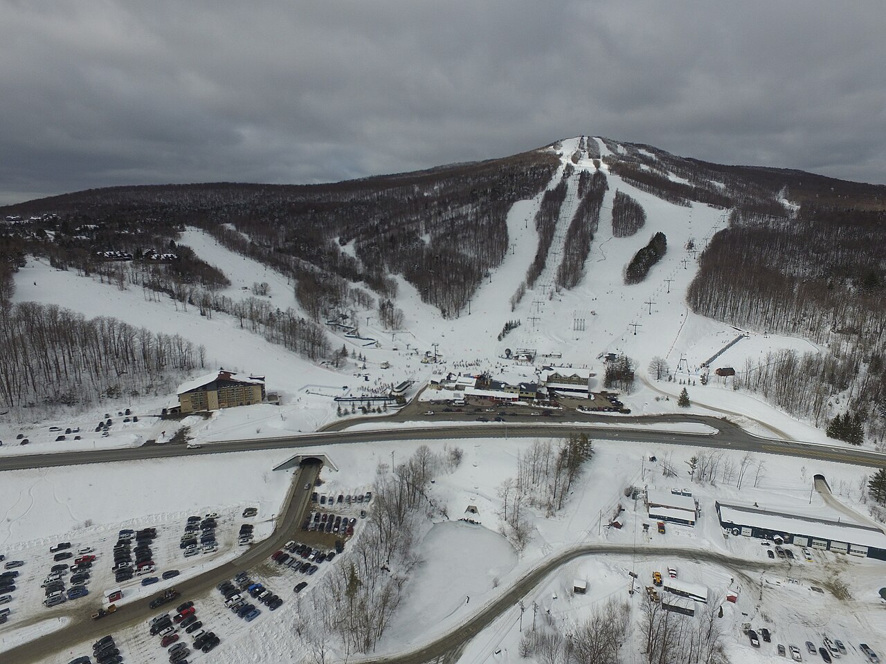
Bromley Mountain Ski Resort;Bromley Mountain is a downhill ski area in Vermont, United States. Mapped terrain includes beginner, easy, intermediate, advanced routes. Its mapped lift network extends from approximately 603 to 997 metres above sea level.
Data: OpenSkiData / OpenSkiMap, OpenStreetMap contributors (ODbL), Skimap.org, Who's On First, Mapterhorn.
Bromley Mountain Ski Resort;Bromley Mountain - Base lift station
ECMWF · Model run: Next update expected:
Day Time (UTC) Temp. (°C) Humidity (%) Wind (km/h) Wind (knots) Wind (Bft) Direction Precip. (mm) Snow (cm) Pressure (hPa) Freezing (m) Conditions | Thursday, 05/11 06:00 12.2 76 14 8 3B SW — — 1013 3107 Clear 6% cloud 09:00 12 87 21 11 4B SW 0 0 1013 3091 Partly cloudy 26% cloud 12:00 13 97 18 10 3B SW 0.11 0 1012 3084 Overcast 100% cloud 15:00 15.7 98 21 11 4B SW 2.4 0 1011 3076 Overcast 100% cloud 18:00 16.3 98 18 10 3B SW 3.6 0 1009 3063 Overcast 98% cloud 21:00 16.4 93 17 9 3B SW 1.0 0 1009 3059 Cloudy 62% cloud Friday, 06/11 00:00 15.5 97 22 12 4B SW 0.31 0 1010 3063 Cloudy 53% cloud 03:00 14.9 99 17 9 3B SW 0.61 0 1010 3061 Overcast 98% cloud 06:00 14.8 99 14 8 3B W 1.2 0 1010 3054 Overcast 100% cloud 09:00 12.5 99 7 4 2B W 0.40 0 1012 3051 Overcast 86% cloud 12:00 10.5 97 4 2 1B W 0.03 0 1013 3056 Overcast 95% cloud 15:00 14 76 2 1 1B W 0 0 1013 3053 Cloudy 59% cloud 18:00 17.1 54 6 3 2B W 0 0 1011 3041 Clear 15% cloud 21:00 14.7 68 8 4 2B NW 0 0 1011 2988 Partly cloudy 34% cloud Saturday, 07/11 00:00 10.7 79 6 3 2B N 0 0 1012 3039 Cloudy 74% cloud 03:00 10.3 79 12 7 2B NE 0 0 1012 2981 Overcast 100% cloud 06:00 9.3 85 10 6 2B E 0 0 1011 2735 Partly cloudy 38% cloud 09:00 8.7 91 8 4 2B E 0.01 0 1010 2845 Partly cloudy 34% cloud 12:00 8.6 93 11 6 2B E 0.21 0 1011 2716 Overcast 80% cloud 15:00 9.8 87 10 6 2B E 0.55 0 1011 2654 Overcast 100% cloud 18:00 10.8 83 9 5 2B E 0.44 0 1008 2619 Overcast 100% cloud 21:00 9.8 94 2 1 1B SE 0.67 0 1008 2429 Overcast 100% cloud Sunday, 08/11 00:00 8.4 98 4 2 1B E 2.7 0 1008 2230 Overcast 100% cloud 03:00 6.8 100 1 0 0B SE 3.7 0 1007 2015 Overcast 100% cloud 06:00 5.2 100 8 4 2B NW 4.4 0 1007 1847 Overcast 100% cloud 09:00 3 100 16 9 3B NW 3.2 0 1008 1656 Overcast 100% cloud 12:00 2.7 98 16 8 3B NW 0.47 0 1009 1378 Overcast 100% cloud 15:00 5 85 19 10 3B W 0.01 0 1009 1381 Overcast 100% cloud 18:00 6.8 80 22 12 4B W 0.10 0 1007 1494 Overcast 99% cloud 21:00 6.8 69 22 12 4B W 0.10 0 1006 1492 Clear 7% cloud Monday, 09/11 00:00 4.7 73 16 8 3B W 0 0 1005 1537 Overcast 97% cloud 03:00 4.8 87 18 10 3B W 0.26 0 1005 1380 Overcast 99% cloud 06:00 4.4 99 21 11 4B W 0.93 0 1004 1406 Overcast 100% cloud 09:00 4.3 98 21 11 4B W 1.1 0 1004 1305 Overcast 96% cloud 12:00 3.9 98 21 11 4B W 0.67 0 1005 1197 Overcast 100% cloud 15:00 4 93 19 10 3B W 0.98 0 1007 1128 Overcast 98% cloud 18:00 4.7 84 20 11 3B NW 0.91 0 1007 1153 Overcast 93% cloud 21:00 4.9 68 22 12 4B NW 0.04 0 1009 1122 Overcast 99% cloud Tuesday, 10/11 00:00 3.8 71 22 12 4B W 0.10 0 1011 1034 Overcast 96% cloud 03:00 2.9 76 19 10 3B W 0 0 1012 996 Overcast 85% cloud 06:00 2.7 80 19 10 3B W 0 0 1013 1026 Overcast 91% cloud 09:00 2.3 82 16 9 3B W 0 0 1013 1183 Overcast 88% cloud 12:00 2.4 85 15 8 3B W 0 0 1013 1552 Overcast 98% cloud 15:00 4.8 78 19 10 3B W 0 0 1012 1435 Overcast 100% cloud 18:00 6.8 68 17 9 3B W 0 0 1009 1819 Overcast 82% cloud 21:00 7.1 73 16 9 3B SW 0.05 0 1007 1618 Overcast 98% cloud Wednesday, 11/11 00:00 5.7 95 21 11 4B W 0.94 0 1008 1599 Cloudy 69% cloud 03:00 5.4 95 17 9 3B W 0.18 0 1009 1433 Cloudy 66% cloud 06:00 4.6 95 19 10 3B W 0 0 1010 1472 Overcast 82% cloud |
|---|
Forecast notes
Forecast table times: UTC.
Coordinates: 43.2130115°N, -72.9356731°E · Requested elevation: 603 m. Model terrain: 559 m. Terrain and 1000/925/850/700 hPa profiles are used for height estimates.
These are altitude estimates, not a simulation of local mountain terrain. Precipitation, cloud and sea-level pressure use horizontal interpolation only.
Precipitation includes rain and snow water equivalent: preceding 3 hours through day 6, then 6 hours (see cell tooltip). Snow (cm) estimates fresh snowfall from precipitation and temperature using the GFS conversion; it is not snow depth on the ground. Freezing (m) uses additional 600/500 hPa temperatures when available and estimates the lowest resolved 0°C crossing above sea level. When all sampled levels are warm, the upper profile limit is shown (see tooltip). < marks an entirely cold sampled profile and its lower height limit. No extrapolation is used.
Source: ECMWF · CC BY 4.0 · Processed by Snow Report.
Bromley Mountain Ski Resort;Bromley Mountain - Top lift station
ECMWF · Model run: Next update expected:
Day Time (UTC) Temp. (°C) Humidity (%) Wind (km/h) Wind (knots) Wind (Bft) Direction Precip. (mm) Snow (cm) Pressure (hPa) Freezing (m) Conditions | Thursday, 05/11 06:00 16 48 37 20 5B SW — — 1013 3106 Clear 5% cloud 09:00 13.3 74 49 27 6B SW 0 0 1013 3091 Partly cloudy 25% cloud 12:00 13 92 46 25 6B SW 0.11 0 1012 3084 Overcast 100% cloud 15:00 13.9 96 50 27 7B SW 2.2 0 1011 3076 Overcast 100% cloud 18:00 14.4 98 39 21 6B SW 3.7 0 1009 3063 Overcast 98% cloud 21:00 14.4 95 38 20 5B SW 1.0 0 1009 3059 Cloudy 60% cloud Friday, 06/11 00:00 14.4 94 48 26 6B SW 0.31 0 1009 3062 Cloudy 50% cloud 03:00 13.5 95 41 22 6B SW 0.60 0 1010 3060 Overcast 98% cloud 06:00 12.8 98 34 18 5B W 1.3 0 1010 3054 Overcast 100% cloud 09:00 10.6 92 24 13 4B W 0.37 0 1012 3050 Overcast 87% cloud 12:00 9.9 84 18 10 3B W 0.03 0 1013 3055 Overcast 96% cloud 15:00 10.6 73 14 7 3B SW 0 0 1013 3053 Cloudy 59% cloud 18:00 12.7 64 10 6 2B SW 0 0 1011 3041 Clear 15% cloud 21:00 12.2 66 7 4 2B W 0 0 1011 2983 Partly cloudy 34% cloud Saturday, 07/11 00:00 11.3 69 9 5 2B NE 0 0 1012 3039 Cloudy 72% cloud 03:00 10.1 77 20 11 4B NE 0 0 1012 2971 Overcast 100% cloud 06:00 9.9 79 20 11 4B E 0 0 1011 2729 Partly cloudy 35% cloud 09:00 8 93 15 8 3B E 0.01 0 1010 2841 Partly cloudy 30% cloud 12:00 8.1 91 20 11 4B E 0.17 0 1011 2714 Cloudy 79% cloud 15:00 8.5 88 23 12 4B E 0.42 0 1011 2651 Overcast 100% cloud 18:00 8.1 89 17 9 3B E 0.46 0 1008 2617 Overcast 100% cloud 21:00 7.4 97 8 4 2B E 0.65 0 1008 2430 Overcast 100% cloud Sunday, 08/11 00:00 6.2 99 8 4 2B E 2.7 0 1008 2232 Overcast 100% cloud 03:00 4.8 99 5 3 1B E 3.5 0 1007 2018 Overcast 100% cloud 06:00 3.6 100 13 7 3B NW 4.5 0 1007 1847 Overcast 100% cloud 09:00 2 100 43 23 6B NW 3.2 0 1008 1651 Overcast 100% cloud 12:00 1.3 97 43 23 6B NW 0.44 0 1009 1367 Overcast 100% cloud 15:00 2.4 92 39 21 6B NW 0.01 0 1009 1378 Overcast 100% cloud 18:00 3.4 89 37 20 5B W 0.10 0 1007 1485 Overcast 100% cloud 21:00 3.5 72 39 21 5B W 0.10 0 1006 1473 Clear 8% cloud Monday, 09/11 00:00 2.7 78 43 23 6B W 0 0 1005 1532 Overcast 97% cloud 03:00 2.3 93 38 20 5B W 0.25 0 1005 1377 Overcast 99% cloud 06:00 2.2 99 45 24 6B W 0.88 0 1004 1404 Overcast 100% cloud 09:00 1.9 97 41 22 6B W 1.1 0 1004 1304 Overcast 95% cloud 12:00 1.3 98 41 22 6B W 0.66 0 1005 1196 Overcast 100% cloud 15:00 1 96 35 19 5B NW 1.00 0.3 1007 1125 Overcast 98% cloud 18:00 1.3 91 34 18 5B NW 0.91 0 1007 1153 Overcast 94% cloud 21:00 1.2 82 36 19 5B NW 0.04 0 1009 1120 Overcast 100% cloud Tuesday, 10/11 00:00 0.3 83 43 23 6B NW 0.10 0 1011 1034 Overcast 96% cloud 03:00 -0 86 41 22 6B NW 0 0 1012 995 Overcast 86% cloud 06:00 0.1 83 35 19 5B NW 0 0 1013 1019 Overcast 92% cloud 09:00 0.7 76 33 18 5B NW 0 0 1013 1161 Overcast 89% cloud 12:00 1.3 77 35 19 5B W 0 0 1013 1479 Overcast 99% cloud 15:00 2.5 71 33 18 5B W 0 0 1012 1404 Overcast 100% cloud 18:00 4.1 61 31 16 5B W 0 0 1009 1812 Overcast 83% cloud 21:00 4 81 37 20 5B W 0.05 0 1007 1612 Overcast 98% cloud Wednesday, 11/11 00:00 3.4 96 46 25 6B W 0.97 0 1008 1591 Cloudy 66% cloud 03:00 2.8 93 39 21 6B W 0.19 0 1009 1421 Cloudy 66% cloud 06:00 2.4 87 38 20 5B W 0 0 1010 1453 Overcast 82% cloud |
|---|
Forecast notes
Forecast table times: UTC.
Coordinates: 43.2273912°N, -72.9394904°E · Requested elevation: 997 m. Model terrain: 553 m. Terrain and 1000/925/850/700 hPa profiles are used for height estimates.
These are altitude estimates, not a simulation of local mountain terrain. Precipitation, cloud and sea-level pressure use horizontal interpolation only.
Precipitation includes rain and snow water equivalent: preceding 3 hours through day 6, then 6 hours (see cell tooltip). Snow (cm) estimates fresh snowfall from precipitation and temperature using the GFS conversion; it is not snow depth on the ground. Freezing (m) uses additional 600/500 hPa temperatures when available and estimates the lowest resolved 0°C crossing above sea level. When all sampled levels are warm, the upper profile limit is shown (see tooltip). < marks an entirely cold sampled profile and its lower height limit. No extrapolation is used.