Worldwide Ski Resort Forecasts

More
Colour guide Temperature · Wind · Rain · Snow
Each colour starts at the value shown. Wind colours match across all three units. Dry cells stay neutral. Colours describe the displayed values, not official weather warnings.
Togari Onsen Ski Resort - Low lift station
ECMWF · Model run: Next update expected:
Day Time (UTC) Temp. (°C) Humidity (%) Wind (km/h) Wind (knots) Wind (Bft) Direction Precip. (mm) Snow (cm) Pressure (hPa) Freezing (m) Conditions | Thursday, 05/11 06:00 19 60 4 2 1B NW — — 1010 3052 Partly cloudy 31% cloud  09:00 14.1 81 1 0 0B S 0.01 0 1009 3042 Overcast 94% cloud  12:00 14 82 1 1 1B S 0.46 0 1007 3027 Overcast 98% cloud 15:00 13.5 78 1 1 1B SW 0.06 0 1006 3013 Overcast 80% cloud 18:00 13 83 1 1 1B W 1.3 0 1005 2997 Overcast 93% cloud 21:00 12.2 92 5 2 1B NW 4.4 0 1008 2876 Overcast 100% cloud Friday, 06/11 00:00 14.3 88 6 3 2B NW 1.7 0 1010 2746 Cloudy 70% cloud  03:00 18.1 50 11 6 2B NW 0.60 0 1008 2730 Partly cloudy 35% cloud 06:00 15.6 64 13 7 3B NW 0.19 0 1010 2702 Partly cloudy 35% cloud 09:00 11.1 78 11 6 2B NW 0.10 0 1014 2438 Partly cloudy 24% cloud 12:00 8.5 90 10 5 2B NW 0.25 0 1017 1943 Overcast 93% cloud 15:00 7.4 91 11 6 2B NW 3.2 0 1019 1558 Overcast 100% cloud 18:00 6.3 91 9 5 2B NW 3.5 0 1019 1402 Overcast 96% cloud 21:00 5.7 90 3 2 1B W 0.82 0 1020 1450 Cloudy 71% cloud Saturday, 07/11 00:00 6.5 89 11 6 2B NW 2.4 0 1023 1346 Overcast 100% cloud 03:00 6.6 85 10 6 2B NW 4.3 0 1024 1309 Overcast 89% cloud 06:00 6 82 12 6 2B NW 2.9 0 1026 1254 Overcast 84% cloud 09:00 4.8 88 9 5 2B NW 2.0 0 1029 1138 Overcast 84% cloud 12:00 4.2 88 7 4 2B NW 0.85 0 1030 1065 Cloudy 79% cloud 15:00 3.8 83 6 3 2B W 0.13 0 1032 1038 Cloudy 76% cloud 18:00 4.4 85 8 4 2B NW 0.31 0 1032 1072 Overcast 88% cloud 21:00 4.4 85 5 3 1B NW 0.47 0 1033 1066 Overcast 83% cloud Sunday, 08/11 00:00 6.4 77 7 4 2B NW 0.25 0 1035 1225 Overcast 89% cloud 03:00 8.4 59 11 6 2B NW 0.14 0 1033 1337 Overcast 94% cloud 06:00 7.8 59 8 4 2B N 0 0 1032 1343 Overcast 86% cloud 09:00 5.6 70 1 1 1B NE 0 0 1032 1350 Overcast 89% cloud 12:00 5.2 71 1 1 1B SE 0 0 1032 1499 Overcast 87% cloud 15:00 4.7 72 1 1 1B SE 0.04 0 1030 2006 Overcast 85% cloud 18:00 4.8 72 1 1 1B SE 0 0 1028 2072 Overcast 99% cloud 21:00 5 75 2 1 1B S 0.08 0 1026 2195 Overcast 95% cloud Monday, 09/11 00:00 10 61 2 1 1B SW 0.02 0 1025 2320 Overcast 86% cloud 03:00 13.2 52 5 3 1B NW 0 0 1021 2300 Cloudy 50% cloud 06:00 12.2 63 6 3 1B N 0.04 0 1021 2211 Cloudy 70% cloud 09:00 8 85 2 1 1B NW 0.28 0 1021 2103 Overcast 89% cloud 12:00 7.4 92 10 5 2B NW 5.0 0 1024 1547 Overcast 100% cloud 15:00 5.9 90 6 3 2B NW 3.3 0 1025 1250 Overcast 99% cloud 18:00 4.7 90 5 3 1B NW 1.3 0 1025 1092 Overcast 97% cloud 21:00 4.2 88 6 3 2B NW 0.46 0 1026 1032 Overcast 92% cloud Tuesday, 10/11 00:00 5.1 85 8 4 2B NW 0.82 0 1027 1119 Overcast 83% cloud 03:00 5.2 84 9 5 2B NW 2.8 0 1027 1142 Overcast 95% cloud 06:00 4.4 86 7 4 2B NW 2.3 0 1027 1020 Overcast 96% cloud 09:00 3.6 89 3 2 1B N 0.45 0 1028 951 Overcast 93% cloud 12:00 2.8 88 2 1 1B E 0.10 0 1028 892 Cloudy 74% cloud 15:00 2.2 86 3 1 1B S 0 0 1028 803 Cloudy 54% cloud 18:00 1.4 83 3 1 1B S 0 0 1028 < 655 Cloudy 63% cloud 21:00 2.3 81 3 1 1B S 0 0 1029 819 Cloudy 64% cloud Wednesday, 11/11 00:00 6.7 63 5 3 1B NW 0.03 0 1031 1220 Cloudy 61% cloud 03:00 9 52 8 4 2B NW 0 0 1030 1369 Partly cloudy 44% cloud 06:00 8.8 52 7 4 2B N 0 0 1030 1465 Clear 10% cloud  |
|---|
Forecast notes
Forecast table times: UTC.
Coordinates: 36.9314639°N, 138.3873188°E · Requested elevation: 387 m. Model terrain: 653 m. Terrain and 1000/925/850/700 hPa profiles are used for height estimates.
Outside the available profile, temperature uses an estimated 5.5°C/km height correction; wind retains the nearest available model-level value. Humidity is estimated with adjusted pressure and temperature.
These are altitude estimates, not a simulation of local mountain terrain. Precipitation, cloud and sea-level pressure use horizontal interpolation only.
Precipitation includes rain and snow water equivalent: preceding 3 hours through day 6, then 6 hours (see cell tooltip). Snow (cm) estimates fresh snowfall from precipitation and temperature using the GFS conversion; it is not snow depth on the ground. Freezing (m) uses additional 600/500 hPa temperatures when available and estimates the lowest resolved 0°C crossing above sea level. When all sampled levels are warm, the upper profile limit is shown (see tooltip). < marks an entirely cold sampled profile and its lower height limit. No extrapolation is used.
Source: ECMWF · CC BY 4.0 · Processed by Snow Report.
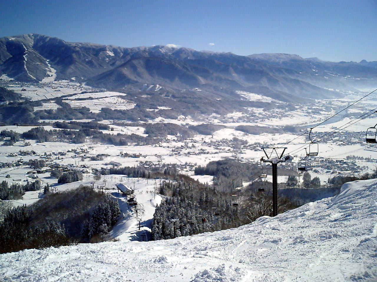
Togari Onsen Ski Resort is a downhill ski area in Nagano Prefecture, Japan. Mapped terrain includes easy, intermediate, advanced routes. Its mapped lift network extends from approximately 387 to 845 metres above sea level.
Data: OpenSkiData / OpenSkiMap, OpenStreetMap contributors (ODbL), Skimap.org, Who's On First, Mapterhorn.
Togari Onsen Ski Resort - Base lift station
ECMWF · Model run: Next update expected:
Day Time (UTC) Temp. (°C) Humidity (%) Wind (km/h) Wind (knots) Wind (Bft) Direction Precip. (mm) Snow (cm) Pressure (hPa) Freezing (m) Conditions | Thursday, 05/11 06:00 18.7 61 4 2 1B NW — — 1010 3052 Partly cloudy 32% cloud 09:00 13.7 82 1 0 0B S 0.01 0 1009 3042 Overcast 95% cloud 12:00 13.6 83 1 1 0B S 0.45 0 1007 3027 Overcast 98% cloud 15:00 13.2 80 1 1 1B SW 0.06 0 1006 3013 Overcast 81% cloud 18:00 12.7 85 1 1 1B W 1.3 0 1005 2997 Overcast 94% cloud 21:00 11.9 94 5 3 1B NW 4.6 0 1008 2875 Overcast 100% cloud Friday, 06/11 00:00 14 90 6 3 2B NW 1.7 0 1010 2741 Cloudy 69% cloud 03:00 17.8 51 12 6 2B NW 0.52 0 1008 2724 Partly cloudy 33% cloud 06:00 15.2 66 14 7 3B NW 0.17 0 1010 2699 Partly cloudy 35% cloud 09:00 10.7 79 11 6 2B NW 0.11 0 1014 2432 Partly cloudy 23% cloud 12:00 8.2 92 10 5 2B NW 0.25 0 1017 1936 Overcast 94% cloud 15:00 7 92 11 6 2B NW 3.2 0 1019 1549 Overcast 100% cloud 18:00 6 92 9 5 2B NW 3.6 0 1019 1397 Overcast 96% cloud 21:00 5.3 92 3 2 1B W 0.79 0 1020 1443 Cloudy 70% cloud Saturday, 07/11 00:00 6.1 91 11 6 2B NW 2.5 0 1023 1337 Overcast 100% cloud 03:00 6.2 87 11 6 2B NW 4.4 0 1024 1301 Overcast 91% cloud 06:00 5.6 84 12 6 2B NW 3.0 0 1026 1246 Overcast 86% cloud 09:00 4.4 90 9 5 2B NW 2.0 0 1029 1133 Overcast 85% cloud 12:00 3.9 90 8 4 2B W 0.89 0 1030 1060 Cloudy 80% cloud 15:00 3.5 85 6 3 2B W 0.13 0 1032 1033 Cloudy 76% cloud 18:00 4.1 86 9 5 2B NW 0.32 0 1032 1067 Overcast 88% cloud 21:00 4 87 5 3 1B NW 0.49 0 1033 1062 Overcast 83% cloud Sunday, 08/11 00:00 6 78 7 4 2B NW 0.27 0 1035 1220 Overcast 90% cloud 03:00 8 60 11 6 2B NW 0.15 0 1033 1331 Overcast 94% cloud 06:00 7.5 60 7 4 2B N 0 0 1032 1337 Overcast 86% cloud 09:00 5.3 71 1 1 1B NE 0 0 1032 1341 Overcast 90% cloud 12:00 4.9 73 2 1 1B SE 0 0 1032 1491 Overcast 88% cloud 15:00 4.3 74 1 1 1B SE 0.04 0 1030 2001 Overcast 85% cloud 18:00 4.4 74 2 1 1B SE 0 0 1028 2067 Overcast 99% cloud 21:00 4.6 77 2 1 1B SE 0.08 0 1026 2191 Overcast 95% cloud Monday, 09/11 00:00 9.7 62 1 1 1B SW 0.02 0 1025 2319 Overcast 86% cloud 03:00 12.9 53 6 3 1B NW 0 0 1021 2296 Cloudy 51% cloud 06:00 11.8 64 6 3 1B NW 0.04 0 1021 2205 Cloudy 72% cloud 09:00 7.7 87 1 1 1B NW 0.28 0 1021 2096 Overcast 90% cloud 12:00 7.1 93 10 5 2B NW 5.1 0 1024 1539 Overcast 100% cloud 15:00 5.6 92 6 3 2B NW 3.4 0 1025 1246 Overcast 99% cloud 18:00 4.4 91 5 3 1B NW 1.3 0 1025 1088 Overcast 97% cloud 21:00 3.9 90 6 3 2B NW 0.48 0 1026 1029 Overcast 92% cloud Tuesday, 10/11 00:00 4.8 87 8 4 2B NW 0.85 0 1027 1115 Overcast 84% cloud 03:00 4.8 87 9 5 2B NW 2.9 0 1027 1135 Overcast 96% cloud 06:00 4 88 7 4 2B NW 2.3 0 1027 1013 Overcast 96% cloud 09:00 3.3 91 3 2 1B N 0.48 0 1028 946 Overcast 94% cloud 12:00 2.5 90 2 1 1B E 0.11 0 1028 888 Cloudy 74% cloud 15:00 1.9 88 3 2 1B S 0 0 1028 798 Cloudy 54% cloud 18:00 1.1 85 3 2 1B S 0 0 1028 < 646 Cloudy 63% cloud 21:00 2 82 3 1 1B S 0 0 1029 822 Cloudy 64% cloud Wednesday, 11/11 00:00 6.4 65 5 3 1B NW 0.03 0 1031 1215 Cloudy 62% cloud 03:00 8.7 53 8 4 2B NW 0 0 1030 1363 Partly cloudy 45% cloud 06:00 8.5 53 7 4 2B N 0 0 1030 1461 Clear 10% cloud |
|---|
Forecast notes
Forecast table times: UTC.
Coordinates: 36.9397223°N, 138.3926377°E · Requested elevation: 445 m. Model terrain: 643 m. Terrain and 1000/925/850/700 hPa profiles are used for height estimates.
Outside the available profile, temperature uses an estimated 5.5°C/km height correction; wind retains the nearest available model-level value. Humidity is estimated with adjusted pressure and temperature.
These are altitude estimates, not a simulation of local mountain terrain. Precipitation, cloud and sea-level pressure use horizontal interpolation only.
Precipitation includes rain and snow water equivalent: preceding 3 hours through day 6, then 6 hours (see cell tooltip). Snow (cm) estimates fresh snowfall from precipitation and temperature using the GFS conversion; it is not snow depth on the ground. Freezing (m) uses additional 600/500 hPa temperatures when available and estimates the lowest resolved 0°C crossing above sea level. When all sampled levels are warm, the upper profile limit is shown (see tooltip). < marks an entirely cold sampled profile and its lower height limit. No extrapolation is used.
Source: ECMWF · CC BY 4.0 · Processed by Snow Report.
Togari Onsen Ski Resort - Top lift station
ECMWF · Model run: Next update expected:
Day Time (UTC) Temp. (°C) Humidity (%) Wind (km/h) Wind (knots) Wind (Bft) Direction Precip. (mm) Snow (cm) Pressure (hPa) Freezing (m) Conditions | Thursday, 05/11 06:00 16 66 5 3 1B SW — — 1009 3052 Partly cloudy 31% cloud 09:00 12.2 84 3 2 1B S 0.01 0 1009 3042 Overcast 95% cloud 12:00 12.2 84 8 4 2B S 0.46 0 1007 3027 Overcast 98% cloud 15:00 11.8 82 6 3 2B SW 0.05 0 1006 3013 Overcast 83% cloud 18:00 11 90 6 3 2B W 1.5 0 1005 2997 Overcast 94% cloud 21:00 10.1 98 13 7 3B NW 4.8 0 1008 2871 Overcast 100% cloud Friday, 06/11 00:00 11.5 93 14 7 3B NW 1.7 0 1010 2743 Cloudy 65% cloud 03:00 14.5 57 16 9 3B W 0.60 0 1008 2726 Partly cloudy 34% cloud 06:00 12.4 71 20 11 4B W 0.20 0 1010 2697 Partly cloudy 36% cloud 09:00 8.5 80 18 10 3B W 0.11 0 1014 2428 Partly cloudy 23% cloud 12:00 6 95 15 8 3B NW 0.29 0 1017 1935 Overcast 93% cloud 15:00 4.6 97 16 8 3B NW 3.5 0 1019 1551 Overcast 100% cloud 18:00 3.6 97 15 8 3B NW 3.9 0 1019 1402 Overcast 96% cloud 21:00 3.2 93 14 7 3B W 0.84 0 1020 1453 Cloudy 69% cloud Saturday, 07/11 00:00 3.5 96 18 10 3B NW 2.6 0 1023 1335 Overcast 100% cloud 03:00 3.5 93 19 10 3B NW 4.6 0 1024 1298 Overcast 92% cloud 06:00 3 91 21 11 4B NW 3.1 0 1026 1245 Overcast 86% cloud 09:00 1.9 95 18 9 3B W 2.1 0 1029 1134 Overcast 85% cloud 12:00 1.4 94 15 8 3B W 0.91 0 1030 1062 Overcast 81% cloud 15:00 1.2 90 14 8 3B W 0.14 0 1032 1039 Cloudy 77% cloud 18:00 1.6 93 15 8 3B NW 0.33 0 1032 1070 Overcast 88% cloud 21:00 1.6 93 11 6 2B NW 0.48 0 1033 1066 Overcast 81% cloud Sunday, 08/11 00:00 3.2 85 11 6 2B NW 0.24 0 1034 1224 Overcast 89% cloud 03:00 4.9 68 13 7 3B NW 0.14 0 1033 1330 Overcast 93% cloud 06:00 4.5 68 9 5 2B N 0 0 1032 1338 Overcast 85% cloud 09:00 3.1 77 2 1 1B N 0 0 1032 1350 Overcast 90% cloud 12:00 3 77 2 1 1B SW 0 0 1032 1492 Overcast 88% cloud 15:00 3.1 75 5 3 1B SW 0.05 0 1030 2006 Overcast 85% cloud 18:00 3.3 75 5 3 1B SW 0 0 1028 2068 Overcast 99% cloud 21:00 3.7 76 6 3 2B SW 0.10 0 1026 2193 Overcast 95% cloud Monday, 09/11 00:00 7.8 64 7 4 2B SW 0.01 0 1025 2316 Overcast 86% cloud 03:00 10.2 57 6 3 2B W 0 0 1021 2292 Cloudy 51% cloud 06:00 9.2 70 7 4 2B NW 0.05 0 1021 2207 Cloudy 71% cloud 09:00 5.9 91 9 5 2B W 0.32 0 1021 2097 Overcast 90% cloud 12:00 4.6 99 15 8 3B NW 5.5 0 1024 1535 Overcast 100% cloud 15:00 3 98 12 6 2B NW 3.3 0 1025 1247 Overcast 99% cloud 18:00 1.8 97 11 6 2B NW 1.4 0 1025 1091 Overcast 97% cloud 21:00 1.3 96 12 7 3B NW 0.48 0 1026 1033 Overcast 91% cloud Tuesday, 10/11 00:00 2.2 93 14 7 3B NW 0.85 0 1027 1120 Overcast 81% cloud 03:00 2.2 93 14 8 3B NW 2.8 0 1027 1138 Overcast 96% cloud 06:00 1.3 95 11 6 2B NW 2.4 0 1027 1016 Overcast 96% cloud 09:00 0.8 96 6 3 2B NW 0.47 0.1 1028 956 Overcast 92% cloud 12:00 0.4 91 4 2 1B NW 0.09 0 1028 914 Cloudy 72% cloud 15:00 -0.1 90 2 1 1B W 0 0 1028 828 Cloudy 55% cloud 18:00 -0.7 90 3 2 1B W 0 0 1028 682 Cloudy 64% cloud 21:00 -0.1 88 4 2 1B W 0 0 1029 823 Cloudy 61% cloud Wednesday, 11/11 00:00 3.4 73 8 4 2B NW 0.03 0 1030 1213 Cloudy 61% cloud 03:00 5.4 61 9 5 2B NW 0 0 1030 1360 Partly cloudy 43% cloud 06:00 5.5 57 8 5 2B N 0 0 1030 1459 Clear 10% cloud |
|---|
Forecast notes
Forecast table times: UTC.
Coordinates: 36.9426249°N, 138.3682805°E · Requested elevation: 845 m. Model terrain: 608 m. Terrain and 1000/925/850/700 hPa profiles are used for height estimates.
These are altitude estimates, not a simulation of local mountain terrain. Precipitation, cloud and sea-level pressure use horizontal interpolation only.
Precipitation includes rain and snow water equivalent: preceding 3 hours through day 6, then 6 hours (see cell tooltip). Snow (cm) estimates fresh snowfall from precipitation and temperature using the GFS conversion; it is not snow depth on the ground. Freezing (m) uses additional 600/500 hPa temperatures when available and estimates the lowest resolved 0°C crossing above sea level. When all sampled levels are warm, the upper profile limit is shown (see tooltip). < marks an entirely cold sampled profile and its lower height limit. No extrapolation is used.