SNOWREPORT
METEOCAM
Worldwide Ski Resort Forecasts
GFS, ECMWF & ICON weather models
Up to 16-day outlook
2,272 ski resorts Newest resort: Moose Mountain Ski Resort ↗
125 snow cams Newest camera: Skeetawk ↗
Mountain weather expertise since 1996

More
Colour guide Temperature · Wind · Rain · Snow
Temperature °C< −10 / −10 / 0 / 10 / 20 / 30+
Wind km/h< 10 / 10 / 29 / 50 / 75+
Rain mm< 1 / 1 / 3 / 10 / 20+
Snow cm< 1 / 1 / 5 / 10 / 20+
Each colour starts at the value shown. Wind colours match across all three units. Dry cells stay neutral. Colours describe the displayed values, not official weather warnings.
Niseko United - Low lift station
ECMWF · Model run: Next update expected:
Day Time (UTC) Temp. (°C) Humidity (%) Wind (km/h) Wind (knots) Wind (Bft) Direction Precip. (mm) Snow (cm) Pressure (hPa) Freezing (m) Conditions | Thursday, 05/11 06:00 12.4 68 4 2 1B SE — — 1014 2210 Overcast 100% cloud  09:00 8.6 87 4 2 1B E 0.86 0 1012 2326 Overcast 100% cloud 12:00 7.8 94 3 2 1B NE 7.8 0 1008 2383 Overcast 100% cloud 15:00 7.7 95 2 1 1B NW 8.8 0 1005 2380 Overcast 100% cloud 18:00 7.5 96 2 1 1B N 1.0 0 1002 2241 Overcast 99% cloud 21:00 7.4 98 5 2 1B N 0.24 0 1001 2022 Overcast 96% cloud Friday, 06/11 00:00 10.1 91 1 1 1B S 0 0 1001 1828 Partly cloudy 27% cloud  03:00 13.1 60 12 6 2B SW 0.19 0 999 1807 Partly cloudy 41% cloud 06:00 10 81 14 8 3B SW 0.59 0 998 1720 Overcast 85% cloud 09:00 4.5 90 21 12 4B W 2.3 0 1003 843 Overcast 85% cloud 12:00 1.3 91 20 11 4B W 1.1 0 1006 441 Cloudy 75% cloud  15:00 -0.4 75 22 12 4B W 1.2 0.4 1007 < 310 Overcast 81% cloud 18:00 -1.5 72 19 10 3B W 1.7 0.5 1007 < 310 Overcast 84% cloud 21:00 -1.8 70 21 11 4B W 1.4 0.4 1007 < 310 Cloudy 76% cloud Saturday, 07/11 00:00 -0.8 72 23 12 4B W 1.5 0.4 1007 < 310 Overcast 80% cloud 03:00 -0.2 71 27 15 4B W 1.7 0.5 1007 < 310 Overcast 82% cloud 06:00 0 77 24 13 4B W 1.6 0.5 1008 < 310 Cloudy 76% cloud 09:00 -0.7 83 22 12 4B W 1.5 0.5 1011 < 310 Overcast 84% cloud 12:00 -0.5 83 20 11 3B NW 1.5 0.5 1013 < 310 Overcast 82% cloud 15:00 -0.6 85 20 11 4B NW 2.0 0.6 1016 < 310 Overcast 91% cloud 18:00 -0.7 87 20 11 4B NW 1.9 0.6 1018 < 310 Overcast 92% cloud 21:00 -0.9 87 18 10 3B NW 1.9 0.6 1021 < 310 Overcast 97% cloud Sunday, 08/11 00:00 -0 80 17 9 3B NW 1.3 0.4 1024 < 310 Overcast 93% cloud 03:00 0.5 76 18 10 3B W 0.97 0.3 1025 335 Overcast 98% cloud 06:00 -0.1 79 16 9 3B W 0.45 0.1 1026 < 310 Overcast 92% cloud 09:00 -1 83 9 5 2B W 0.15 0 1028 < 310 Overcast 98% cloud 12:00 -1.2 83 8 4 2B W 0.17 0 1028 < 310 Overcast 98% cloud 15:00 -1.6 84 6 3 2B W 0.08 0 1028 < 310 Overcast 97% cloud 18:00 -2.2 86 5 3 1B W 0.24 0 1027 < 310 Overcast 91% cloud 21:00 -3 88 5 3 1B W 0.32 0.3 1027 < 310 Overcast 84% cloud Monday, 09/11 00:00 -1 77 8 4 2B W 0.40 0.1 1027 < 310 Cloudy 79% cloud 03:00 -0 65 11 6 2B W 0.40 0.1 1025 < 310 Cloudy 71% cloud 06:00 -1.5 72 8 4 2B NW 0.43 0.1 1023 < 310 Cloudy 77% cloud 09:00 -5.4 88 4 2 1B NW 0.20 0.2 1023 < 310 Partly cloudy 40% cloud 12:00 -8.6 87 2 1 1B NE 0.14 0.1 1023 < 310 Overcast 82% cloud 15:00 -9.8 85 2 1 1B N 0.04 0 1021 < 310 Overcast 88% cloud 18:00 -9.3 83 2 1 1B NE 0.28 0.3 1020 < 310 Overcast 90% cloud 21:00 -9.8 85 1 1 0B NE 0.43 0.4 1021 < 310 Overcast 90% cloud Tuesday, 10/11 00:00 -3.4 66 2 1 1B N 0.08 0.1 1023 < 310 Partly cloudy 49% cloud 03:00 -0.6 55 10 5 2B N 0.09 0 1023 < 310 Partly cloudy 26% cloud 06:00 -1.6 65 7 4 2B N 0.13 0 1025 < 310 Clear 17% cloud  09:00 -6.8 83 1 0 0B N 0.11 0.1 1026 < 310 Clear 12% cloud 12:00 -8.9 86 0 0 0B E 0.02 0 1027 < 310 Overcast 84% cloud 15:00 -8.6 86 3 2 1B SE 0 0 1027 < 310 Overcast 99% cloud 18:00 -7.4 85 3 2 1B SE 0.04 0 1027 < 310 Overcast 83% cloud 21:00 -4.6 83 2 1 1B S 0.21 0.2 1027 < 310 Overcast 97% cloud Wednesday, 11/11 00:00 0 73 3 1 1B S 0.15 0 1027 < 310 Cloudy 51% cloud 03:00 1.8 65 7 4 2B SW 0.17 0 1026 451 Cloudy 79% cloud 06:00 1.1 77 5 3 1B SW 0.52 0.2 1026 412 Overcast 94% cloud |
|---|
Forecast notes
Forecast table times: UTC.
Coordinates: 42.8583452°N, 140.7020096°E · Requested elevation: 257 m. Model terrain: 308 m. Terrain and 1000/925/850/700 hPa profiles are used for height estimates.
Outside the available profile, temperature uses an estimated 5.5°C/km height correction; wind retains the nearest available model-level value. Humidity is estimated with adjusted pressure and temperature.
These are altitude estimates, not a simulation of local mountain terrain. Precipitation, cloud and sea-level pressure use horizontal interpolation only.
Precipitation includes rain and snow water equivalent: preceding 3 hours through day 6, then 6 hours (see cell tooltip). Snow (cm) estimates fresh snowfall from precipitation and temperature using the GFS conversion; it is not snow depth on the ground. Freezing (m) uses additional 600/500 hPa temperatures when available and estimates the lowest resolved 0°C crossing above sea level. When all sampled levels are warm, the upper profile limit is shown (see tooltip). < marks an entirely cold sampled profile and its lower height limit. No extrapolation is used.
Source: ECMWF · CC BY 4.0 · Processed by Snow Report.
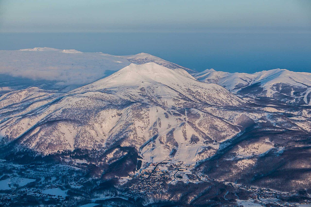
Niseko United brings together Hanazono, Grand Hirafu, Niseko Village and Annupuri on the slopes of Niseko Annupuri in Hokkaido. The shared mountain is the reason these names appear together, but they remain different bases with their own facilities and lift information. Choose the base you will actually use when planning a meeting point or reading a webcam.
The area’s winter snowfall is associated with air that picks up moisture over the Sea of Japan. That background explains its reputation; it is not a promise of fresh powder on every visit. Use the forecast for your dates rather than a seasonal snowfall figure to judge whether a particular day is likely to bring new snow.
Our default reference is a lower lift point at 257 m. It does not represent the entire mountain or the summit of Niseko Annupuri. Compare a higher point when planning upper-mountain skiing and check each resort’s live lift status for connections. Keep the same elevation and time period when switching models; their snowfall estimates are predictions, not observations of snow already on the ground.
Official sources: Niseko United · ニセコユナイテッド. Reviewed 18 October 2026.
Resort cameras
Niseko United - Base lift station
ECMWF · Model run: Next update expected:
Day Time (UTC) Temp. (°C) Humidity (%) Wind (km/h) Wind (knots) Wind (Bft) Direction Precip. (mm) Snow (cm) Pressure (hPa) Freezing (m) Conditions | Thursday, 05/11 06:00 12.2 69 4 2 1B SE — — 1014 2209 Overcast 100% cloud 09:00 8.4 88 4 2 1B E 0.83 0 1012 2325 Overcast 100% cloud 12:00 7.6 95 3 2 1B NE 7.7 0 1008 2381 Overcast 100% cloud 15:00 7.5 97 1 1 1B NW 8.8 0 1005 2378 Overcast 100% cloud 18:00 7.3 97 2 1 1B N 1.1 0 1002 2238 Overcast 99% cloud 21:00 7.1 99 5 2 1B N 0.25 0 1001 2018 Overcast 96% cloud Friday, 06/11 00:00 9.9 92 1 1 1B S 0 0 1001 1826 Partly cloudy 26% cloud 03:00 12.8 61 12 6 2B SW 0.19 0 999 1807 Partly cloudy 41% cloud 06:00 9.8 82 14 8 3B SW 0.60 0 998 1718 Overcast 85% cloud 09:00 4.2 91 21 12 4B W 2.3 0 1003 842 Overcast 85% cloud 12:00 1 92 21 11 4B W 1.1 0.3 1006 441 Cloudy 75% cloud 15:00 -0.7 76 22 12 4B W 1.3 0.4 1007 < 309 Overcast 81% cloud 18:00 -1.8 73 19 10 3B W 1.7 0.5 1007 < 309 Overcast 84% cloud 21:00 -2.1 71 21 11 4B W 1.4 0.4 1007 < 309 Cloudy 76% cloud Saturday, 07/11 00:00 -1.1 73 23 12 4B W 1.5 0.4 1007 < 309 Overcast 80% cloud 03:00 -0.5 72 27 15 4B W 1.7 0.5 1007 < 309 Overcast 82% cloud 06:00 -0.2 78 25 13 4B W 1.6 0.5 1008 < 309 Cloudy 76% cloud 09:00 -0.9 84 22 12 4B W 1.5 0.5 1011 < 309 Overcast 84% cloud 12:00 -0.8 84 20 11 4B NW 1.5 0.5 1013 < 309 Overcast 81% cloud 15:00 -0.8 86 21 11 4B NW 2.0 0.6 1016 < 309 Overcast 90% cloud 18:00 -1 88 21 11 4B NW 1.9 0.6 1018 < 309 Overcast 92% cloud 21:00 -1.2 88 18 10 3B NW 1.9 0.6 1021 < 309 Overcast 97% cloud Sunday, 08/11 00:00 -0.3 81 17 9 3B NW 1.3 0.4 1024 < 309 Overcast 93% cloud 03:00 0.3 77 18 10 3B W 0.95 0.3 1025 334 Overcast 98% cloud 06:00 -0.3 80 16 9 3B W 0.45 0.1 1026 < 309 Overcast 92% cloud 09:00 -1.3 84 10 5 2B W 0.15 0 1028 < 309 Overcast 98% cloud 12:00 -1.4 84 9 5 2B W 0.18 0 1028 < 309 Overcast 98% cloud 15:00 -1.8 85 6 3 2B W 0.08 0 1028 < 309 Overcast 97% cloud 18:00 -2.4 87 6 3 1B W 0.25 0 1027 < 309 Overcast 92% cloud 21:00 -3.2 89 5 3 1B W 0.33 0.3 1027 < 309 Overcast 84% cloud Monday, 09/11 00:00 -1.2 78 8 4 2B W 0.41 0.1 1027 < 309 Cloudy 80% cloud 03:00 -0.3 66 11 6 2B W 0.42 0.1 1025 < 309 Cloudy 71% cloud 06:00 -1.7 73 8 4 2B NW 0.45 0.1 1023 < 309 Cloudy 78% cloud 09:00 -5.7 90 3 2 1B NW 0.21 0.2 1023 < 309 Partly cloudy 41% cloud 12:00 -8.9 89 2 1 1B NE 0.14 0.1 1023 < 309 Overcast 82% cloud 15:00 -10.1 86 2 1 1B N 0.05 0 1021 < 309 Overcast 88% cloud 18:00 -9.6 84 2 1 1B NE 0.29 0.3 1020 < 309 Overcast 90% cloud 21:00 -10 86 1 1 1B NE 0.44 0.4 1021 < 309 Overcast 90% cloud Tuesday, 10/11 00:00 -3.7 67 2 1 1B N 0.08 0.1 1023 < 309 Partly cloudy 50% cloud 03:00 -0.9 55 10 5 2B N 0.09 0 1023 < 309 Partly cloudy 27% cloud 06:00 -1.9 65 7 4 2B N 0.14 0 1025 < 309 Clear 18% cloud 09:00 -7 84 0 0 0B N 0.11 0.1 1026 < 309 Clear 12% cloud 12:00 -9.1 87 1 0 0B E 0.02 0 1027 < 309 Overcast 84% cloud 15:00 -8.9 87 3 2 1B SE 0 0 1027 < 309 Overcast 99% cloud 18:00 -7.6 87 3 2 1B SE 0.04 0 1027 < 309 Overcast 84% cloud 21:00 -4.8 84 3 1 1B S 0.22 0.2 1027 < 309 Overcast 97% cloud Wednesday, 11/11 00:00 -0.3 74 3 2 1B S 0.16 0 1027 < 309 Cloudy 51% cloud 03:00 1.5 66 7 4 2B SW 0.18 0 1026 449 Cloudy 79% cloud 06:00 0.9 78 5 3 1B SW 0.54 0.2 1026 411 Overcast 95% cloud |
|---|
Forecast notes
Forecast table times: UTC.
Coordinates: 42.8640813°N, 140.7006193°E · Requested elevation: 305 m. Model terrain: 307 m. Terrain and 1000/925/850/700 hPa profiles are used for height estimates.
Outside the available profile, temperature uses an estimated 5.5°C/km height correction; wind retains the nearest available model-level value. Humidity is estimated with adjusted pressure and temperature.
These are altitude estimates, not a simulation of local mountain terrain. Precipitation, cloud and sea-level pressure use horizontal interpolation only.
Precipitation includes rain and snow water equivalent: preceding 3 hours through day 6, then 6 hours (see cell tooltip). Snow (cm) estimates fresh snowfall from precipitation and temperature using the GFS conversion; it is not snow depth on the ground. Freezing (m) uses additional 600/500 hPa temperatures when available and estimates the lowest resolved 0°C crossing above sea level. When all sampled levels are warm, the upper profile limit is shown (see tooltip). < marks an entirely cold sampled profile and its lower height limit. No extrapolation is used.
Source: ECMWF · CC BY 4.0 · Processed by Snow Report.
Niseko United - Top lift station
ECMWF · Model run: Next update expected:
Day Time (UTC) Temp. (°C) Humidity (%) Wind (km/h) Wind (knots) Wind (Bft) Direction Precip. (mm) Snow (cm) Pressure (hPa) Freezing (m) Conditions | Thursday, 05/11 06:00 6.2 65 19 10 3B S — — 1014 2210 Overcast 100% cloud 09:00 6.9 80 23 12 4B S 0.73 0 1012 2324 Overcast 100% cloud 12:00 6.4 96 32 17 5B SE 7.5 0 1008 2376 Overcast 100% cloud 15:00 6.3 97 14 8 3B S 8.9 0 1005 2367 Overcast 100% cloud 18:00 5.2 96 12 7 2B NW 1.0 0 1002 2225 Overcast 98% cloud 21:00 4 91 20 11 4B NW 0.26 0 1001 2006 Overcast 94% cloud Friday, 06/11 00:00 3.7 68 28 15 4B W 0 0 1001 1823 Partly cloudy 28% cloud 03:00 4.1 79 34 18 5B SW 0.19 0 999 1811 Partly cloudy 43% cloud 06:00 3.3 92 49 27 6B SW 0.82 0 998 1705 Overcast 89% cloud 09:00 -2.6 91 64 34 8B W 2.5 0.8 1003 841 Overcast 82% cloud 12:00 -5.6 85 71 38 8B W 1.3 1.3 1006 436 Cloudy 75% cloud 15:00 -7.8 79 78 42 9B W 1.4 1.4 1007 < 299 Cloudy 79% cloud 18:00 -8.8 79 75 40 8B W 1.9 1.9 1006 < 299 Overcast 84% cloud 21:00 -8.9 77 75 41 9B W 1.5 1.5 1007 < 299 Cloudy 75% cloud Saturday, 07/11 00:00 -8.7 81 77 42 9B W 1.6 1.6 1007 < 299 Overcast 81% cloud 03:00 -8.4 80 81 44 9B W 1.9 1.9 1007 < 299 Overcast 84% cloud 06:00 -7.6 78 83 45 9B W 1.7 1.7 1008 < 299 Cloudy 75% cloud 09:00 -7.6 81 79 43 9B W 1.7 1.7 1011 < 299 Overcast 84% cloud 12:00 -7.2 86 77 41 9B NW 1.6 1.6 1013 < 299 Cloudy 77% cloud 15:00 -7.5 91 73 39 8B NW 1.9 1.9 1016 < 299 Overcast 89% cloud 18:00 -7.3 85 71 38 8B NW 2.0 2 1019 < 299 Overcast 93% cloud 21:00 -7.7 93 62 33 7B NW 1.9 1.9 1021 < 299 Overcast 98% cloud Sunday, 08/11 00:00 -7.6 88 49 26 6B NW 1.4 1.4 1024 < 299 Overcast 95% cloud 03:00 -7.6 92 44 24 6B W 0.95 0.9 1025 332 Overcast 98% cloud 06:00 -7.8 85 46 25 6B W 0.47 0.5 1026 < 299 Overcast 93% cloud 09:00 -8.1 88 42 23 6B W 0.16 0.2 1028 < 299 Overcast 98% cloud 12:00 -8.1 90 42 23 6B W 0.18 0.2 1028 < 299 Overcast 98% cloud 15:00 -8.2 91 39 21 6B W 0.10 0.1 1028 < 299 Overcast 97% cloud 18:00 -8.5 88 35 19 5B W 0.26 0.3 1027 < 299 Overcast 93% cloud 21:00 -8.8 91 31 17 5B W 0.36 0.4 1027 < 299 Overcast 87% cloud Monday, 09/11 00:00 -8.9 84 28 15 4B W 0.44 0.4 1027 < 299 Overcast 82% cloud 03:00 -8.7 80 25 13 4B W 0.47 0.5 1025 < 299 Cloudy 73% cloud 06:00 -9.1 81 22 12 4B W 0.52 0.5 1023 < 299 Overcast 81% cloud 09:00 -9.5 78 19 10 3B NW 0.29 0.3 1024 < 299 Partly cloudy 47% cloud 12:00 -9.5 65 16 9 3B NW 0.16 0.2 1023 < 299 Overcast 84% cloud 15:00 -9.7 68 13 7 3B NW 0.08 0.1 1021 < 299 Overcast 89% cloud 18:00 -9.9 68 12 6 2B N 0.33 0.3 1020 < 299 Overcast 91% cloud 21:00 -9.9 74 18 10 3B N 0.42 0.4 1021 < 299 Overcast 90% cloud Tuesday, 10/11 00:00 -9.6 62 20 11 4B N 0.10 0.1 1023 < 299 Cloudy 52% cloud 03:00 -9.2 70 22 12 4B N 0.08 0.1 1023 < 299 Partly cloudy 32% cloud 06:00 -8.7 69 28 15 4B N 0.16 0.2 1025 < 299 Clear 19% cloud 09:00 -8.4 70 17 9 3B N 0.12 0.1 1026 < 299 Clear 15% cloud 12:00 -8.3 70 9 5 2B NW 0.04 0 1027 < 299 Overcast 85% cloud 15:00 -8.3 78 17 9 3B W 0 0 1027 < 299 Overcast 100% cloud 18:00 -7.8 86 26 14 4B W 0.08 0.1 1027 < 299 Overcast 86% cloud 21:00 -7.7 93 26 14 4B W 0.32 0.3 1027 < 299 Overcast 97% cloud Wednesday, 11/11 00:00 -7.5 83 23 12 4B W 0.20 0.2 1027 < 299 Cloudy 55% cloud 03:00 -6.7 89 22 12 4B W 0.24 0.2 1026 442 Overcast 82% cloud 06:00 -6 93 25 14 4B W 0.64 0.6 1026 414 Overcast 95% cloud |
|---|
Forecast notes
Forecast table times: UTC.
Coordinates: 42.8708178°N, 140.6624025°E · Requested elevation: 1183 m. Model terrain: 297 m. Terrain and 1000/925/850/700 hPa profiles are used for height estimates.
These are altitude estimates, not a simulation of local mountain terrain. Precipitation, cloud and sea-level pressure use horizontal interpolation only.
Precipitation includes rain and snow water equivalent: preceding 3 hours through day 6, then 6 hours (see cell tooltip). Snow (cm) estimates fresh snowfall from precipitation and temperature using the GFS conversion; it is not snow depth on the ground. Freezing (m) uses additional 600/500 hPa temperatures when available and estimates the lowest resolved 0°C crossing above sea level. When all sampled levels are warm, the upper profile limit is shown (see tooltip). < marks an entirely cold sampled profile and its lower height limit. No extrapolation is used.