Worldwide Ski Resort Forecasts

More
Colour guide Temperature · Wind · Rain · Snow
Each colour starts at the value shown. Wind colours match across all three units. Dry cells stay neutral. Colours describe the displayed values, not official weather warnings.
Amihari Onsen Ski Resort - Low lift station
ECMWF · Model run: Next update expected:
Day Time (UTC) Temp. (°C) Humidity (%) Wind (km/h) Wind (knots) Wind (Bft) Direction Precip. (mm) Snow (cm) Pressure (hPa) Freezing (m) Conditions | Thursday, 05/11 06:00 10.1 95 10 5 2B SE — — 1013 2924 Overcast 100% cloud  09:00 9.9 96 7 4 2B SE 0.11 0 1010 3020 Overcast 100% cloud 12:00 9.7 95 5 3 1B SW 0.28 0 1007 2982 Overcast 100% cloud 15:00 9.3 93 8 4 2B W 0.15 0 1004 2977 Overcast 99% cloud 18:00 8.7 97 9 5 2B W 0.48 0 1003 2884 Overcast 100% cloud 21:00 9.1 97 14 7 3B W 2.9 0 1002 2691 Overcast 100% cloud Friday, 06/11 00:00 10.6 95 16 9 3B W 0.41 0 1004 2467 Overcast 94% cloud 03:00 11.8 73 26 14 4B W 0.67 0 1003 2277 Partly cloudy 46% cloud  06:00 9.8 90 30 16 5B W 1.5 0 1003 2324 Overcast 91% cloud 09:00 6.4 82 31 16 5B W 0.37 0 1008 1722 Overcast 96% cloud 12:00 3.3 90 33 18 5B W 1.2 0 1011 1142 Overcast 97% cloud 15:00 1.1 82 32 17 5B W 0.80 0.2 1013 801 Overcast 88% cloud 18:00 0.2 80 25 13 4B W 0.21 0 1013 688 Overcast 84% cloud 21:00 0.1 86 22 12 4B W 1.5 0.4 1014 668 Overcast 100% cloud Saturday, 07/11 00:00 0.8 76 27 15 4B W 1.3 0.4 1015 735 Cloudy 65% cloud  03:00 1.8 60 35 19 5B W 0.85 0 1014 827 Partly cloudy 50% cloud 06:00 0.7 70 30 16 5B W 0.90 0.3 1016 732 Cloudy 56% cloud 09:00 -0.2 78 30 16 5B W 0.94 0.3 1019 624 Overcast 89% cloud 12:00 -0 78 28 15 4B W 0.82 0.2 1020 648 Cloudy 68% cloud 15:00 -0.2 77 27 15 4B W 0.55 0.2 1022 626 Cloudy 73% cloud 18:00 -0.6 74 26 14 4B W 0.51 0.2 1025 576 Overcast 85% cloud 21:00 -0.8 79 23 13 4B W 0.43 0.1 1027 548 Overcast 88% cloud Sunday, 08/11 00:00 1.3 69 31 17 5B W 0.25 0 1027 806 Overcast 86% cloud 03:00 2.3 64 31 17 5B W 0.07 0 1028 883 Overcast 88% cloud 06:00 1.7 65 27 15 4B W 0.02 0 1029 813 Overcast 82% cloud 09:00 0.4 73 18 10 3B W 0 0 1030 706 Overcast 80% cloud 12:00 0.2 75 14 8 3B W 0 0 1030 691 Overcast 99% cloud 15:00 0 76 11 6 2B W 0.03 0 1030 662 Overcast 94% cloud 18:00 -1 87 11 6 2B W 0.16 0 1029 < 528 Overcast 92% cloud 21:00 -1.5 86 9 5 2B W 0.03 0 1028 < 528 Overcast 88% cloud Monday, 09/11 00:00 2.4 73 7 4 2B W 0 0 1027 979 Overcast 94% cloud 03:00 3.8 71 8 4 2B SW 0.02 0 1024 1103 Overcast 99% cloud 06:00 3 82 6 3 2B W 0.29 0 1022 1084 Overcast 100% cloud 09:00 1.7 98 7 4 2B W 1.3 0 1021 984 Overcast 99% cloud 12:00 1.4 96 10 5 2B W 0.62 0 1021 873 Overcast 89% cloud 15:00 -0.1 90 19 10 3B W 0.14 0 1020 644 Overcast 87% cloud 18:00 -1.2 84 26 14 4B W 0.17 0 1020 < 528 Cloudy 76% cloud 21:00 -1.5 80 26 14 4B W 0.16 0 1020 < 528 Overcast 92% cloud Tuesday, 10/11 00:00 -0.8 71 26 14 4B W 0.40 0.1 1022 562 Overcast 89% cloud 03:00 -0.5 63 24 13 4B W 0.16 0 1022 606 Overcast 90% cloud 06:00 -0.9 62 16 9 3B NW 0.18 0 1024 564 Cloudy 76% cloud 09:00 -3.5 75 6 3 2B NW 0.02 0 1026 < 528 Clear 19% cloud  12:00 -5.2 80 5 3 1B NW 0 0 1028 < 528 Cloudy 67% cloud 15:00 -5 80 3 2 1B W 0 0 1028 < 528 Cloudy 69% cloud 18:00 -3.4 77 5 2 1B W 0 0 1028 < 528 Cloudy 67% cloud 21:00 -2.1 83 6 3 2B W 0.09 0 1028 < 528 Overcast 100% cloud Wednesday, 11/11 00:00 -0.6 82 6 3 2B W 0.59 0.2 1029 567 Overcast 99% cloud 03:00 0.7 81 10 5 2B W 0.71 0.2 1028 743 Overcast 100% cloud 06:00 1.4 83 12 7 2B W 0.52 0 1028 820 Overcast 86% cloud |
|---|
Forecast notes
Forecast table times: UTC.
Coordinates: 39.8164147°N, 140.9346342°E · Requested elevation: 650 m. Model terrain: 526 m. Terrain and 1000/925/850/700 hPa profiles are used for height estimates.
These are altitude estimates, not a simulation of local mountain terrain. Precipitation, cloud and sea-level pressure use horizontal interpolation only.
Precipitation includes rain and snow water equivalent: preceding 3 hours through day 6, then 6 hours (see cell tooltip). Snow (cm) estimates fresh snowfall from precipitation and temperature using the GFS conversion; it is not snow depth on the ground. Freezing (m) uses additional 600/500 hPa temperatures when available and estimates the lowest resolved 0°C crossing above sea level. When all sampled levels are warm, the upper profile limit is shown (see tooltip). < marks an entirely cold sampled profile and its lower height limit. No extrapolation is used.
Source: ECMWF · CC BY 4.0 · Processed by Snow Report.
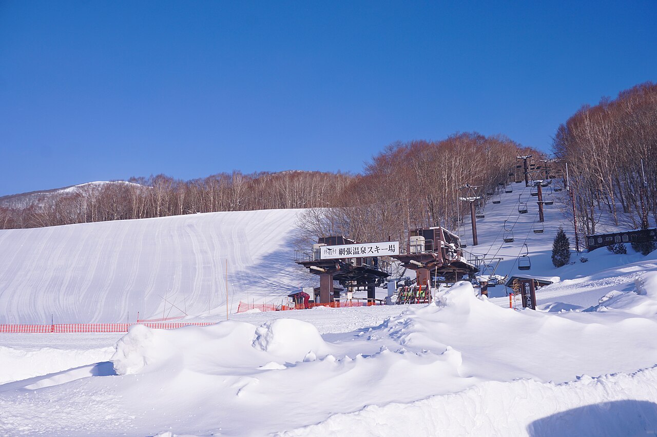
Amihari Onsen Ski Resort is a downhill ski area in Iwate Prefecture, Japan. Mapped terrain includes easy, intermediate, advanced routes. Its mapped lift network extends from approximately 650 to 1324 metres above sea level.
Data: OpenSkiData / OpenSkiMap, OpenStreetMap contributors (ODbL), Skimap.org, Who's On First, Mapterhorn.
Amihari Onsen Ski Resort - Base lift station
ECMWF · Model run: Next update expected:
Day Time (UTC) Temp. (°C) Humidity (%) Wind (km/h) Wind (knots) Wind (Bft) Direction Precip. (mm) Snow (cm) Pressure (hPa) Freezing (m) Conditions | Thursday, 05/11 06:00 9.7 94 17 9 3B SE — — 1013 2924 Overcast 100% cloud 09:00 9.6 95 13 7 3B S 0.11 0 1010 3020 Overcast 100% cloud 12:00 9.5 95 9 5 2B SW 0.28 0 1007 2981 Overcast 100% cloud 15:00 9 92 13 7 3B W 0.15 0 1004 2977 Overcast 99% cloud 18:00 8.5 97 15 8 3B W 0.47 0 1003 2884 Overcast 100% cloud 21:00 8.7 97 20 11 4B W 2.8 0 1002 2691 Overcast 100% cloud Friday, 06/11 00:00 9.7 95 22 12 4B W 0.41 0 1004 2466 Overcast 94% cloud 03:00 10.7 75 31 17 5B W 0.65 0 1003 2276 Partly cloudy 46% cloud 06:00 9 89 38 20 5B W 1.5 0 1003 2324 Overcast 92% cloud 09:00 5.5 83 38 21 5B W 0.37 0 1008 1721 Overcast 96% cloud 12:00 2.5 89 41 22 6B W 1.2 0 1011 1141 Overcast 97% cloud 15:00 0.2 81 40 21 6B W 0.80 0.2 1013 800 Overcast 88% cloud 18:00 -0.6 80 33 18 5B W 0.22 0 1013 686 Overcast 85% cloud 21:00 -0.8 87 30 16 5B W 1.5 0.5 1014 668 Overcast 100% cloud Saturday, 07/11 00:00 -0.3 78 36 19 5B W 1.3 0.4 1015 734 Cloudy 66% cloud 03:00 0.6 62 44 24 6B W 0.85 0.3 1014 825 Cloudy 51% cloud 06:00 -0.3 71 40 22 6B W 0.92 0.3 1016 730 Cloudy 57% cloud 09:00 -1.1 80 38 21 5B W 0.97 0.3 1019 623 Overcast 89% cloud 12:00 -0.9 80 36 20 5B W 0.85 0.3 1020 646 Cloudy 69% cloud 15:00 -1.1 79 36 19 5B W 0.56 0.2 1022 624 Cloudy 73% cloud 18:00 -1.5 76 34 18 5B W 0.53 0.2 1025 573 Overcast 85% cloud 21:00 -1.6 80 30 16 5B W 0.46 0.1 1027 545 Overcast 88% cloud Sunday, 08/11 00:00 0.3 70 37 20 5B W 0.26 0.1 1027 803 Overcast 86% cloud 03:00 1.1 66 35 19 5B W 0.07 0 1028 882 Overcast 88% cloud 06:00 0.5 69 34 19 5B W 0.02 0 1029 812 Overcast 82% cloud 09:00 -0.4 74 25 14 4B W 0 0 1030 705 Overcast 81% cloud 12:00 -0.4 76 20 11 4B W 0 0 1030 690 Overcast 99% cloud 15:00 -0.5 75 17 9 3B W 0.04 0 1030 660 Overcast 94% cloud 18:00 -1.6 87 15 8 3B W 0.17 0 1029 < 532 Overcast 92% cloud 21:00 -2 86 13 7 3B W 0.03 0 1028 < 532 Overcast 88% cloud Monday, 09/11 00:00 1.5 76 10 6 2B W 0 0 1027 977 Overcast 94% cloud 03:00 2.8 74 10 5 2B SW 0.02 0 1024 1101 Overcast 99% cloud 06:00 2.2 84 8 4 2B W 0.29 0 1022 1082 Overcast 100% cloud 09:00 1.1 98 8 5 2B W 1.3 0.4 1021 980 Overcast 99% cloud 12:00 0.6 96 14 7 3B W 0.61 0.2 1021 870 Overcast 89% cloud 15:00 -0.9 87 24 13 4B W 0.14 0 1020 644 Overcast 88% cloud 18:00 -2 83 33 18 5B W 0.17 0 1020 < 532 Cloudy 77% cloud 21:00 -2.4 81 33 18 5B W 0.17 0 1020 < 532 Overcast 92% cloud Tuesday, 10/11 00:00 -2 73 32 17 5B W 0.42 0.1 1022 558 Overcast 89% cloud 03:00 -1.7 67 27 15 4B NW 0.18 0 1022 604 Overcast 90% cloud 06:00 -2.1 65 19 10 3B NW 0.17 0 1024 563 Cloudy 76% cloud 09:00 -4.3 76 9 5 2B NW 0.02 0 1026 < 532 Clear 19% cloud 12:00 -5.6 78 8 4 2B NW 0 0 1028 < 532 Cloudy 66% cloud 15:00 -5.4 80 6 3 1B W 0 0 1028 < 532 Cloudy 70% cloud 18:00 -3.9 79 8 4 2B W 0 0 1028 < 532 Cloudy 66% cloud 21:00 -2.7 85 9 5 2B W 0.09 0 1028 < 532 Overcast 100% cloud Wednesday, 11/11 00:00 -1.4 84 9 5 2B W 0.59 0.2 1029 568 Overcast 99% cloud 03:00 -0.2 83 13 7 3B W 0.74 0.2 1028 742 Overcast 100% cloud 06:00 0.4 84 17 9 3B W 0.53 0.2 1028 818 Overcast 86% cloud |
|---|
Forecast notes
Forecast table times: UTC.
Coordinates: 39.8219894°N, 140.9364554°E · Requested elevation: 766 m. Model terrain: 529 m. Terrain and 1000/925/850/700 hPa profiles are used for height estimates.
These are altitude estimates, not a simulation of local mountain terrain. Precipitation, cloud and sea-level pressure use horizontal interpolation only.
Precipitation includes rain and snow water equivalent: preceding 3 hours through day 6, then 6 hours (see cell tooltip). Snow (cm) estimates fresh snowfall from precipitation and temperature using the GFS conversion; it is not snow depth on the ground. Freezing (m) uses additional 600/500 hPa temperatures when available and estimates the lowest resolved 0°C crossing above sea level. When all sampled levels are warm, the upper profile limit is shown (see tooltip). < marks an entirely cold sampled profile and its lower height limit. No extrapolation is used.
Source: ECMWF · CC BY 4.0 · Processed by Snow Report.
Amihari Onsen Ski Resort - Top lift station
ECMWF · Model run: Next update expected:
Day Time (UTC) Temp. (°C) Humidity (%) Wind (km/h) Wind (knots) Wind (Bft) Direction Precip. (mm) Snow (cm) Pressure (hPa) Freezing (m) Conditions | Thursday, 05/11 06:00 7.8 90 54 29 7B S — — 1013 2925 Overcast 100% cloud 09:00 8.5 92 40 22 6B S 0.10 0 1010 3020 Overcast 100% cloud 12:00 8.5 94 32 17 5B SW 0.29 0 1007 2978 Overcast 100% cloud 15:00 8 86 38 21 5B W 0.15 0 1004 2977 Overcast 99% cloud 18:00 7.4 99 44 24 6B W 0.44 0 1002 2882 Overcast 100% cloud 21:00 6.8 95 54 29 7B W 2.8 0 1002 2692 Overcast 100% cloud Friday, 06/11 00:00 5.5 94 54 29 7B W 0.43 0 1004 2462 Overcast 94% cloud 03:00 5.5 89 59 32 7B W 0.62 0 1003 2273 Partly cloudy 46% cloud 06:00 5.2 79 77 42 9B W 1.5 0 1003 2322 Overcast 92% cloud 09:00 1.6 85 77 41 9B W 0.38 0 1008 1711 Overcast 96% cloud 12:00 -1.3 82 80 43 9B W 1.2 0.4 1011 1133 Overcast 97% cloud 15:00 -4 75 79 43 9B W 0.81 0.8 1013 795 Overcast 88% cloud 18:00 -4.4 84 75 40 8B W 0.23 0.2 1013 681 Overcast 86% cloud 21:00 -5 92 70 38 8B W 1.6 1.6 1014 668 Overcast 100% cloud Saturday, 07/11 00:00 -5.5 82 80 43 9B W 1.4 1.4 1015 730 Cloudy 68% cloud 03:00 -5.1 74 86 46 9B W 0.88 0.9 1014 819 Cloudy 53% cloud 06:00 -5.3 79 89 48 10B W 1.0 1 1016 723 Cloudy 60% cloud 09:00 -5.3 88 81 44 9B W 1.1 1.1 1019 620 Overcast 90% cloud 12:00 -5.3 88 78 42 9B W 0.95 0.9 1020 639 Cloudy 72% cloud 15:00 -5.4 87 75 41 9B W 0.62 0.6 1022 618 Cloudy 75% cloud 18:00 -5.7 85 72 39 8B W 0.62 0.6 1024 565 Overcast 87% cloud 21:00 -5.7 83 65 35 8B W 0.56 0.6 1027 < 544 Overcast 89% cloud Sunday, 08/11 00:00 -4.6 75 68 37 8B W 0.29 0.3 1027 793 Overcast 87% cloud 03:00 -4.4 80 59 32 7B W 0.09 0.1 1028 877 Overcast 89% cloud 06:00 -4.5 80 54 29 7B W 0.02 0 1029 809 Overcast 83% cloud 09:00 -4.6 76 48 26 6B W 0 0 1030 701 Overcast 82% cloud 12:00 -4.7 78 42 23 6B W 0 0 1030 687 Overcast 99% cloud 15:00 -4.6 82 38 20 5B W 0.04 0 1030 655 Overcast 94% cloud 18:00 -4.6 85 36 19 5B W 0.18 0.2 1029 < 544 Overcast 92% cloud 21:00 -4.1 87 30 16 5B W 0.03 0 1028 < 544 Overcast 89% cloud Monday, 09/11 00:00 -2.6 88 24 13 4B W 0 0 1027 972 Overcast 94% cloud 03:00 -2 91 19 10 3B SW 0.02 0 1024 1096 Overcast 99% cloud 06:00 -1.7 95 19 10 3B SW 0.30 0.1 1022 1074 Overcast 100% cloud 09:00 -1.8 99 19 10 3B SW 1.3 0.4 1021 966 Overcast 99% cloud 12:00 -2.9 96 32 17 5B W 0.61 0.6 1021 862 Overcast 90% cloud 15:00 -4.8 70 51 28 7B W 0.14 0.1 1020 644 Overcast 88% cloud 18:00 -5.9 78 71 38 8B W 0.17 0.2 1020 < 544 Cloudy 77% cloud 21:00 -6.4 83 70 38 8B W 0.20 0.2 1020 < 544 Overcast 93% cloud Tuesday, 10/11 00:00 -7.2 83 62 34 8B W 0.51 0.5 1022 545 Overcast 90% cloud 03:00 -7.7 87 43 23 6B NW 0.22 0.2 1022 599 Overcast 90% cloud 06:00 -7.7 85 29 16 5B NW 0.16 0.2 1024 561 Cloudy 77% cloud 09:00 -7.9 77 24 13 4B NW 0.02 0 1026 < 544 Clear 19% cloud 12:00 -7.5 69 19 10 3B NW 0 0 1028 < 544 Cloudy 65% cloud 15:00 -7.3 83 16 9 3B W 0 0 1028 < 544 Cloudy 71% cloud 18:00 -6.4 87 22 12 4B W 0 0 1028 < 544 Cloudy 65% cloud 21:00 -5.6 93 27 14 4B W 0.08 0.1 1028 < 544 Overcast 100% cloud Wednesday, 11/11 00:00 -5.3 92 28 15 4B W 0.62 0.6 1029 571 Overcast 99% cloud 03:00 -4.7 93 32 18 5B W 0.82 0.8 1028 739 Overcast 100% cloud 06:00 -4.1 91 39 21 5B W 0.59 0.6 1028 812 Overcast 87% cloud |
|---|
Forecast notes
Forecast table times: UTC.
Coordinates: 39.8394192°N, 140.9387782°E · Requested elevation: 1324 m. Model terrain: 541 m. Terrain and 1000/925/850/700 hPa profiles are used for height estimates.
These are altitude estimates, not a simulation of local mountain terrain. Precipitation, cloud and sea-level pressure use horizontal interpolation only.
Precipitation includes rain and snow water equivalent: preceding 3 hours through day 6, then 6 hours (see cell tooltip). Snow (cm) estimates fresh snowfall from precipitation and temperature using the GFS conversion; it is not snow depth on the ground. Freezing (m) uses additional 600/500 hPa temperatures when available and estimates the lowest resolved 0°C crossing above sea level. When all sampled levels are warm, the upper profile limit is shown (see tooltip). < marks an entirely cold sampled profile and its lower height limit. No extrapolation is used.