Worldwide Ski Resort Forecasts

More
Colour guide Temperature · Wind · Rain · Snow
Each colour starts at the value shown. Wind colours match across all three units. Dry cells stay neutral. Colours describe the displayed values, not official weather warnings.
Ishiuchi Maruyama Ski Resort - Low lift station
ECMWF · Model run: Next update expected:
Day Local time Temp. (°C) Humidity (%) Wind (km/h) Wind (knots) Wind (Bft) Direction Precip. (mm) Snow (cm) Pressure (hPa) Freezing (m) Conditions | Friday, 06/11 00:00 12.3 81 2 1 1B S 0.08 0 1006 3015 Partly cloudy 35% cloud  03:00 12.6 80 1 1 1B SW 0.19 0 1005 2996 Overcast 84% cloud  06:00 12.5 87 3 1 1B W 3.1 0 1007 2923 Overcast 100% cloud 09:00 14.6 86 9 5 2B NW 3.2 0 1010 2781 Cloudy 72% cloud  12:00 18.1 52 14 7 3B NW 0.56 0 1009 2705 Partly cloudy 21% cloud 15:00 15 74 7 4 2B NW 0.36 0 1010 2646 Cloudy 60% cloud 18:00 12.2 77 9 5 2B NW 1.00 0 1014 2385 Cloudy 55% cloud 21:00 9.1 84 9 5 2B NW 0.55 0 1017 1962 Overcast 88% cloud Saturday, 07/11 00:00 7.9 89 12 6 2B NW 2.5 0 1019 1517 Overcast 100% cloud 03:00 6.9 88 11 6 2B NW 3.9 0 1019 1355 Overcast 100% cloud 06:00 6.1 87 4 2 1B N 1.5 0 1020 1363 Cloudy 62% cloud 09:00 6.4 84 15 8 3B NW 2.1 0 1023 1283 Overcast 98% cloud 12:00 6.3 85 12 7 3B W 4.8 0 1024 1221 Overcast 99% cloud 15:00 6 84 13 7 3B NW 4.2 0 1026 1178 Overcast 94% cloud 18:00 4.9 87 10 6 2B NW 3.5 0 1029 1081 Overcast 90% cloud 21:00 5 84 10 5 2B W 1.3 0 1030 1033 Overcast 90% cloud Sunday, 08/11 00:00 4.5 80 7 4 2B W 0.26 0 1032 993 Cloudy 72% cloud 03:00 4.8 82 7 4 2B NW 0.63 0 1032 1036 Overcast 92% cloud 06:00 4.7 84 7 4 2B W 0.95 0 1033 1026 Overcast 92% cloud 09:00 6.6 77 10 5 2B W 0.83 0 1034 1183 Overcast 94% cloud 12:00 8.2 64 12 6 2B NW 0.65 0 1033 1285 Overcast 99% cloud 15:00 8.3 58 7 4 2B NW 0.14 0 1032 1304 Overcast 97% cloud 18:00 6.9 68 2 1 1B NW 0 0 1033 1334 Overcast 92% cloud 21:00 5.3 74 1 0 0B SE 0 0 1033 1484 Overcast 98% cloud Monday, 09/11 00:00 5.3 73 1 1 0B S 0.02 0 1030 1869 Overcast 85% cloud 03:00 5.5 71 1 0 0B SW 0 0 1029 1981 Overcast 99% cloud 06:00 5.7 71 1 1 1B S 0 0 1027 2171 Overcast 93% cloud 09:00 10 60 1 0 0B NE 0 0 1025 2316 Overcast 90% cloud 12:00 13.8 48 5 3 1B N 0.01 0 1021 2330 Partly cloudy 49% cloud 15:00 12.7 55 5 3 1B NW 0 0 1021 2107 Cloudy 66% cloud 18:00 8.8 73 2 1 1B W 0 0 1021 2076 Overcast 85% cloud 21:00 8.1 89 10 5 2B NW 3.8 0 1024 1675 Overcast 100% cloud Tuesday, 10/11 00:00 6.6 86 8 4 2B NW 5.1 0 1025 1272 Overcast 100% cloud 03:00 5.3 87 9 5 2B NW 1.7 0 1025 1061 Overcast 100% cloud 06:00 4.7 87 9 5 2B NW 1.0 0 1026 1011 Overcast 98% cloud 09:00 5.3 82 11 6 2B NW 2.4 0 1027 1069 Overcast 100% cloud 12:00 5.2 84 11 6 2B NW 3.4 0 1026 1076 Overcast 100% cloud 15:00 5 83 10 5 2B NW 2.1 0 1026 1002 Overcast 100% cloud 18:00 4.3 84 7 4 2B NW 0.67 0 1028 933 Overcast 99% cloud 21:00 3.9 85 1 1 0B SW 0.40 0 1029 895 Overcast 87% cloud Wednesday, 11/11 00:00 2.6 86 4 2 1B S 0 0 1028 747 Cloudy 59% cloud 03:00 1.4 86 4 2 1B S 0 0 1029 < 624 Overcast 82% cloud 06:00 2.9 82 4 2 1B S 0 0 1030 789 Overcast 83% cloud 09:00 6.7 62 1 1 1B SE 0 0 1031 1149 Overcast 88% cloud 12:00 9.2 53 7 4 2B NW 0.05 0 1030 1321 Overcast 80% cloud 15:00 9.5 49 9 5 2B NW 0 0 1030 1401 Clear 12% cloud  |
|---|
Forecast notes
Forecast table times: Asia/Tokyo.
Coordinates: 36.9785276°N, 138.80259°E · Requested elevation: 258 m. Model terrain: 621 m. Terrain and 1000/925/850/700 hPa profiles are used for height estimates.
Outside the available profile, temperature uses an estimated 5.5°C/km height correction; wind retains the nearest available model-level value. Humidity is estimated with adjusted pressure and temperature.
These are altitude estimates, not a simulation of local mountain terrain. Precipitation, cloud and sea-level pressure use horizontal interpolation only.
Precipitation includes rain and snow water equivalent: preceding 3 hours through day 6, then 6 hours (see cell tooltip). Snow (cm) estimates fresh snowfall from precipitation and temperature using the GFS conversion; it is not snow depth on the ground. Freezing (m) uses additional 600/500 hPa temperatures when available and estimates the lowest resolved 0°C crossing above sea level. When all sampled levels are warm, the upper profile limit is shown (see tooltip). < marks an entirely cold sampled profile and its lower height limit. No extrapolation is used.
Source: ECMWF · CC BY 4.0 · Processed by Snow Report.
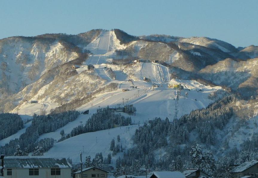
Ishiuchi Maruyama Ski Resort is a downhill ski area in Niigata Prefecture, Japan. Mapped terrain includes easy, intermediate, advanced routes. Its mapped lift network extends from approximately 258 to 916 metres above sea level.
Data: OpenSkiData / OpenSkiMap, OpenStreetMap contributors (ODbL), Skimap.org, Who's On First, Mapterhorn.
Ishiuchi Maruyama Ski Resort - Base lift station
ECMWF · Model run: Next update expected:
Day Local time Temp. (°C) Humidity (%) Wind (km/h) Wind (knots) Wind (Bft) Direction Precip. (mm) Snow (cm) Pressure (hPa) Freezing (m) Conditions | Friday, 06/11 00:00 11.7 83 2 1 1B S 0.08 0 1006 3015 Partly cloudy 35% cloud 03:00 12 82 1 1 1B SW 0.19 0 1005 2996 Overcast 84% cloud 06:00 11.9 89 3 1 1B W 2.9 0 1007 2929 Overcast 100% cloud 09:00 14 89 9 5 2B NW 3.1 0 1010 2795 Cloudy 73% cloud 12:00 17.4 54 13 7 3B NW 0.51 0 1009 2720 Partly cloudy 23% cloud 15:00 14.4 75 7 4 2B NW 0.36 0 1010 2656 Cloudy 59% cloud 18:00 11.5 79 9 5 2B NW 0.89 0 1014 2403 Cloudy 56% cloud 21:00 8.5 86 9 5 2B NW 0.50 0 1017 1979 Overcast 88% cloud Saturday, 07/11 00:00 7.2 91 12 6 2B NW 2.3 0 1019 1531 Overcast 100% cloud 03:00 6.2 90 11 6 2B NW 3.7 0 1019 1363 Overcast 100% cloud 06:00 5.4 89 4 2 1B N 1.5 0 1020 1370 Cloudy 63% cloud 09:00 5.8 86 14 8 3B NW 2.0 0 1023 1296 Overcast 98% cloud 12:00 5.7 87 12 7 3B W 4.6 0 1024 1235 Overcast 98% cloud 15:00 5.4 86 14 7 3B NW 4.0 0 1026 1191 Overcast 94% cloud 18:00 4.2 89 11 6 2B NW 3.3 0 1029 1087 Overcast 90% cloud 21:00 4.3 86 10 5 2B W 1.2 0 1030 1040 Overcast 90% cloud Sunday, 08/11 00:00 3.8 81 7 4 2B W 0.25 0 1032 998 Cloudy 73% cloud 03:00 4.2 83 7 4 2B NW 0.59 0 1032 1041 Overcast 92% cloud 06:00 4 86 7 4 2B W 0.91 0 1033 1032 Overcast 92% cloud 09:00 6 78 10 5 2B W 0.77 0 1034 1191 Overcast 94% cloud 12:00 7.6 65 12 6 2B NW 0.61 0 1033 1293 Overcast 99% cloud 15:00 7.6 60 7 4 2B NW 0.13 0 1032 1313 Overcast 97% cloud 18:00 6.1 70 2 1 1B NW 0 0 1032 1343 Overcast 91% cloud 21:00 4.7 76 0 0 0B SE 0 0 1033 1497 Overcast 98% cloud Monday, 09/11 00:00 4.7 75 1 1 0B SW 0.02 0 1030 1874 Overcast 85% cloud 03:00 4.9 72 1 0 0B SW 0 0 1029 1987 Overcast 99% cloud 06:00 5.1 73 1 1 1B S 0 0 1027 2176 Overcast 93% cloud 09:00 9.3 62 1 0 0B NE 0 0 1025 2319 Overcast 90% cloud 12:00 13.1 50 5 3 1B N 0.02 0 1021 2334 Partly cloudy 48% cloud 15:00 12.1 56 5 3 1B NW 0 0 1021 2116 Cloudy 65% cloud 18:00 8.1 75 2 1 1B W 0 0 1021 2083 Overcast 83% cloud 21:00 7.5 91 10 5 2B NW 3.7 0 1024 1686 Overcast 100% cloud Tuesday, 10/11 00:00 5.9 88 8 4 2B NW 5.0 0 1025 1279 Overcast 100% cloud 03:00 4.6 89 9 5 2B NW 1.7 0 1025 1068 Overcast 100% cloud 06:00 4 88 9 5 2B NW 1.0 0 1025 1017 Overcast 98% cloud 09:00 4.7 84 11 6 2B NW 2.3 0 1027 1077 Overcast 100% cloud 12:00 4.6 86 11 6 2B NW 3.3 0 1026 1088 Overcast 100% cloud 15:00 4.3 85 10 5 2B NW 2.0 0 1026 1011 Overcast 100% cloud 18:00 3.6 86 7 4 2B NW 0.64 0 1028 941 Overcast 99% cloud 21:00 3.2 87 1 1 0B W 0.39 0 1029 902 Overcast 85% cloud Wednesday, 11/11 00:00 2 88 3 2 1B S 0 0 1028 752 Cloudy 58% cloud 03:00 0.7 87 3 2 1B S 0 0 1028 < 645 Cloudy 79% cloud 06:00 2.2 84 4 2 1B S 0 0 1029 795 Overcast 82% cloud 09:00 6.1 63 1 0 0B SE 0 0 1031 1159 Overcast 85% cloud 12:00 8.6 54 7 4 2B NW 0.04 0 1030 1332 Cloudy 78% cloud 15:00 8.8 50 9 5 2B N 0 0 1030 1411 Clear 11% cloud |
|---|
Forecast notes
Forecast table times: Asia/Tokyo.
Coordinates: 36.9669815°N, 138.7974399°E · Requested elevation: 382 m. Model terrain: 642 m. Terrain and 1000/925/850/700 hPa profiles are used for height estimates.
Outside the available profile, temperature uses an estimated 5.5°C/km height correction; wind retains the nearest available model-level value. Humidity is estimated with adjusted pressure and temperature.
These are altitude estimates, not a simulation of local mountain terrain. Precipitation, cloud and sea-level pressure use horizontal interpolation only.
Precipitation includes rain and snow water equivalent: preceding 3 hours through day 6, then 6 hours (see cell tooltip). Snow (cm) estimates fresh snowfall from precipitation and temperature using the GFS conversion; it is not snow depth on the ground. Freezing (m) uses additional 600/500 hPa temperatures when available and estimates the lowest resolved 0°C crossing above sea level. When all sampled levels are warm, the upper profile limit is shown (see tooltip). < marks an entirely cold sampled profile and its lower height limit. No extrapolation is used.
Source: ECMWF · CC BY 4.0 · Processed by Snow Report.
Ishiuchi Maruyama Ski Resort - Top lift station
ECMWF · Model run: Next update expected:
Day Local time Temp. (°C) Humidity (%) Wind (km/h) Wind (knots) Wind (Bft) Direction Precip. (mm) Snow (cm) Pressure (hPa) Freezing (m) Conditions | Friday, 06/11 00:00 10.6 84 7 4 2B SW 0.08 0 1006 3015 Partly cloudy 36% cloud 03:00 10.1 88 5 3 1B W 0.19 0 1005 2996 Overcast 86% cloud 06:00 9.6 96 14 7 3B NW 2.9 0 1007 2934 Overcast 100% cloud 09:00 10.7 94 23 12 4B NW 2.8 0 1010 2804 Cloudy 72% cloud 12:00 13.2 61 21 11 4B NW 0.40 0 1009 2728 Partly cloudy 24% cloud 15:00 11.1 80 20 11 3B NW 0.34 0 1010 2664 Cloudy 57% cloud 18:00 8.3 84 22 12 4B NW 0.69 0 1014 2418 Cloudy 54% cloud 21:00 5.5 93 21 11 4B NW 0.40 0 1017 1986 Overcast 87% cloud Saturday, 07/11 00:00 4 98 21 11 4B NW 2.1 0 1019 1533 Overcast 100% cloud 03:00 3 97 21 12 4B NW 3.5 0 1019 1367 Overcast 100% cloud 06:00 2.5 93 18 10 3B NW 1.4 0 1020 1376 Cloudy 62% cloud 09:00 2.6 93 26 14 4B NW 1.9 0 1023 1305 Overcast 97% cloud 12:00 2.4 94 27 15 4B NW 4.5 0 1024 1242 Overcast 98% cloud 15:00 2 93 29 16 5B NW 3.9 0 1026 1197 Overcast 94% cloud 18:00 1.1 95 26 14 4B NW 3.2 1.3 1029 1090 Overcast 90% cloud 21:00 0.9 93 23 13 4B NW 1.2 0.4 1030 1042 Overcast 90% cloud Sunday, 08/11 00:00 0.6 89 20 11 4B NW 0.24 0 1032 1000 Cloudy 72% cloud 03:00 0.9 91 20 11 4B NW 0.56 0.2 1032 1043 Overcast 92% cloud 06:00 0.8 93 18 10 3B NW 0.86 0.3 1033 1037 Overcast 91% cloud 09:00 2.3 87 17 9 3B NW 0.68 0 1034 1196 Overcast 93% cloud 12:00 3.6 76 16 9 3B NW 0.57 0 1033 1296 Overcast 99% cloud 15:00 3.7 70 10 5 2B NW 0.12 0 1032 1317 Overcast 97% cloud 18:00 2.9 76 4 2 1B NW 0 0 1032 1349 Overcast 92% cloud 21:00 2.4 80 3 2 1B W 0 0 1033 1509 Overcast 97% cloud Monday, 09/11 00:00 2.8 77 6 3 2B SW 0.01 0 1030 1881 Overcast 84% cloud 03:00 3.2 74 5 3 1B SW 0 0 1029 1993 Overcast 99% cloud 06:00 3.7 71 6 3 1B SW 0 0 1027 2179 Overcast 92% cloud 09:00 7 62 5 3 1B SW 0 0 1025 2321 Overcast 90% cloud 12:00 9.6 55 5 2 1B W 0.02 0 1021 2338 Partly cloudy 48% cloud 15:00 8.5 65 6 3 2B NW 0 0 1021 2120 Cloudy 65% cloud 18:00 5.7 83 10 6 2B W 0 0 1021 2087 Overcast 83% cloud 21:00 4.5 98 17 9 3B NW 3.6 0 1024 1687 Overcast 100% cloud Tuesday, 10/11 00:00 2.6 95 16 9 3B NW 4.9 0 1025 1282 Overcast 100% cloud 03:00 1.2 96 19 10 3B NW 1.6 0 1025 1072 Overcast 100% cloud 06:00 0.7 96 20 11 4B NW 0.96 0.3 1025 1022 Overcast 98% cloud 09:00 1.3 92 21 11 4B NW 2.2 0 1027 1083 Overcast 100% cloud 12:00 1.3 94 21 11 4B NW 3.2 0 1026 1099 Overcast 100% cloud 15:00 0.8 93 16 9 3B NW 2.0 0.6 1026 1017 Overcast 100% cloud 18:00 0.2 94 12 7 3B NW 0.63 0.2 1028 947 Overcast 98% cloud 21:00 -0 93 7 4 2B NW 0.39 0.1 1028 911 Overcast 84% cloud Wednesday, 11/11 00:00 -0.7 90 5 3 1B W 0 0 1028 776 Cloudy 58% cloud 03:00 -1.6 93 6 3 2B W 0 0 1028 < 632 Cloudy 78% cloud 06:00 -0.5 91 6 3 2B W 0 0 1029 818 Overcast 82% cloud 09:00 2.2 74 6 3 2B NW 0 0 1031 1164 Overcast 85% cloud 12:00 4.4 64 11 6 2B NW 0.03 0 1030 1341 Cloudy 76% cloud 15:00 4.8 58 12 7 3B NW 0 0 1030 1420 Clear 9% cloud |
|---|
Forecast notes
Forecast table times: Asia/Tokyo.
Coordinates: 36.9617552°N, 138.782765°E · Requested elevation: 916 m. Model terrain: 630 m. Terrain and 1000/925/850/700 hPa profiles are used for height estimates.
These are altitude estimates, not a simulation of local mountain terrain. Precipitation, cloud and sea-level pressure use horizontal interpolation only.
Precipitation includes rain and snow water equivalent: preceding 3 hours through day 6, then 6 hours (see cell tooltip). Snow (cm) estimates fresh snowfall from precipitation and temperature using the GFS conversion; it is not snow depth on the ground. Freezing (m) uses additional 600/500 hPa temperatures when available and estimates the lowest resolved 0°C crossing above sea level. When all sampled levels are warm, the upper profile limit is shown (see tooltip). < marks an entirely cold sampled profile and its lower height limit. No extrapolation is used.