Worldwide Ski Resort Forecasts

More
Colour guide Temperature · Wind · Rain · Snow
Each colour starts at the value shown. Wind colours match across all three units. Dry cells stay neutral. Colours describe the displayed values, not official weather warnings.
Preparing forecast graphs…
Times and values match the detailed forecast. Tap or point at a value for details. Scroll each chart sideways for later days. Rain / precipitation is the total water equivalent per forecast interval, including snow; snowfall is fresh snow per interval, not snow depth.
GFS and ECMWF model comparison. Each model retains its own forecast times and horizon. Precipitation and snowfall amounts cover their own forecast intervals; these can differ between models.
Forecast values and model notes
Seli Ski Area - Baby Lifts 1475
ECMWF · Model run: Next update expected:
Day Time (UTC) Temp. (°C) Humidity (%) Wind (km/h) Wind (knots) Wind (Bft) Direction Precip. (mm) Snow (cm) Pressure (hPa) Freezing (m) Conditions | Thursday, 05/11 06:00 3.4 99 7 4 2B E — — 1027 2094 Overcast 100% cloud  09:00 3.3 98 6 3 2B E 0.89 0 1028 2044 Overcast 100% cloud 12:00 3.3 99 4 2 1B E 0.82 0 1028 2052 Overcast 100% cloud 15:00 3.2 98 4 2 1B N 0.91 0 1027 2069 Overcast 100% cloud 18:00 3 98 4 2 1B N 0.30 0 1027 2102 Overcast 96% cloud 21:00 2.6 99 3 1 1B N 0.06 0 1027 2105 Overcast 98% cloud Friday, 06/11 00:00 2.4 98 1 0 0B N 0 0 1026 2131 Overcast 98% cloud 03:00 2.2 98 1 1 1B W 0 0 1025 2183 Overcast 94% cloud 06:00 2.2 98 2 1 1B W 0.10 0 1025 2226 Overcast 92% cloud 09:00 3 91 3 2 1B NW 0.29 0 1024 2362 Overcast 91% cloud 12:00 4.4 80 8 4 2B NW 0.19 0 1022 2538 Cloudy 52% cloud  15:00 4.9 81 10 5 2B NW 0 0 1021 2635 Clear 6% cloud  18:00 5.1 72 13 7 3B NW 0 0 1021 2774 Clear 3% cloud 21:00 4.9 64 11 6 2B N 0 0 1021 2748 Clear 5% cloud Saturday, 07/11 00:00 4.5 63 6 3 1B N 0 0 1022 2657 Clear 5% cloud 03:00 3.8 66 4 2 1B NE 0 0 1022 2560 Clear 0% cloud 06:00 3 74 3 2 1B E 0 0 1024 2436 Cloudy 56% cloud 09:00 3 78 4 2 1B SE 0 0 1025 2322 Cloudy 63% cloud 12:00 3.6 75 3 2 1B S 0 0 1024 2345 Overcast 96% cloud 15:00 3 87 2 1 1B SW 0 0 1025 2286 Overcast 90% cloud 18:00 2.4 84 2 1 1B W 0 0 1026 2204 Cloudy 60% cloud 21:00 1.9 83 2 1 1B SE 0 0 1028 2085 Clear 19% cloud Sunday, 08/11 00:00 1.2 88 4 2 1B SE 0 0 1029 1922 Partly cloudy 24% cloud  03:00 1 95 7 4 2B SE 0.00 0 1029 1795 Overcast 91% cloud 06:00 1.1 97 9 5 2B SE 0.03 0 1031 1763 Overcast 94% cloud 09:00 1.6 96 8 4 2B S 0.12 0 1031 1778 Overcast 88% cloud 12:00 2.4 88 5 2 1B S 0.16 0 1030 1960 Cloudy 74% cloud 15:00 2.3 90 5 3 1B SW 0.01 0 1030 2049 Partly cloudy 49% cloud 18:00 2.1 83 4 2 1B SW 0 0 1031 2067 Overcast 88% cloud 21:00 2.2 72 3 2 1B SW 0 0 1031 2147 Cloudy 72% cloud Monday, 09/11 00:00 2.3 68 4 2 1B S 0 0 1031 2176 Overcast 87% cloud 03:00 2.6 71 5 3 1B SW 0 0 1030 2212 Overcast 99% cloud 06:00 3 75 5 3 1B SW 0.12 0 1030 2276 Overcast 92% cloud 09:00 4 76 11 6 2B S 0.12 0 1030 2300 Overcast 96% cloud 12:00 3.9 85 9 5 2B S 0.41 0 1028 2316 Overcast 100% cloud 15:00 3.9 93 7 4 2B SW 2.0 0 1027 2391 Overcast 100% cloud 18:00 4.2 90 11 6 2B SW 0.66 0 1027 2453 Overcast 91% cloud 21:00 4.3 90 11 6 2B SW 0 0 1027 2487 Cloudy 60% cloud Tuesday, 10/11 00:00 4.6 92 13 7 3B W 0.10 0 1025 2522 Partly cloudy 50% cloud 03:00 4.9 92 13 7 3B W 0 0 1024 2577 Partly cloudy 42% cloud 06:00 5.2 87 10 5 2B W 0 0 1024 2703 Clear 6% cloud 09:00 6.4 85 11 6 2B SW 0 0 1024 2865 Partly cloudy 22% cloud 12:00 6.7 80 13 7 3B W 0 0 1022 2970 Cloudy 79% cloud 15:00 7.1 82 14 8 3B W 0 0 1021 3023 Overcast 82% cloud 18:00 7 84 17 9 3B W 0 0 1021 2966 Cloudy 64% cloud 21:00 7.1 83 17 9 3B W 0 0 1020 2947 Overcast 82% cloud Wednesday, 11/11 00:00 7.5 79 18 10 3B W 0 0 1019 2918 Overcast 81% cloud 03:00 8.1 77 19 11 3B W 0 0 1017 2973 Cloudy 73% cloud 06:00 8.2 81 18 10 3B W 0 0 1018 3066 Overcast 89% cloud |
|---|
Forecast notes
Forecast table times: UTC.
Coordinates: 40.54299°N, 22.010196°E · Requested elevation: 1475 m. Model terrain: 1181 m. Terrain and 1000/925/850/700 hPa profiles are used for height estimates.
These are altitude estimates, not a simulation of local mountain terrain. Precipitation, cloud and sea-level pressure use horizontal interpolation only.
Precipitation includes rain and snow water equivalent: preceding 3 hours through day 6, then 6 hours (see cell tooltip). Snow (cm) estimates fresh snowfall from precipitation and temperature using the GFS conversion; it is not snow depth on the ground. Freezing (m) uses additional 600/500 hPa temperatures when available and estimates the lowest resolved 0°C crossing above sea level. When all sampled levels are warm, the upper profile limit is shown (see tooltip). < marks an entirely cold sampled profile and its lower height limit. No extrapolation is used.
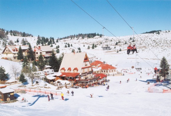
It is located 24 km from Veria, 20 km from Naoussa, 95 km from Thessaloniki and 74 km from Kozani. The main access is through Egnatia Odos and the provincial road of Veria Seliou while the secondary access is through the provincial road of Naoussa Seliou.
Check current ski conditions at Snow Report Seli
Places to stay — Seli
Swipe to see all 5 places to stay →
 Le Bijou Luxury Rooms & Suites
Veria
Drive to ski centre: ≈ 26.3 km · 31 min
View on Booking.com ↗
 Olganos VL Luxury Rooms & Suites
Veria
Drive to ski centre: ≈ 25.8 km · 31 min
View on Booking.com ↗
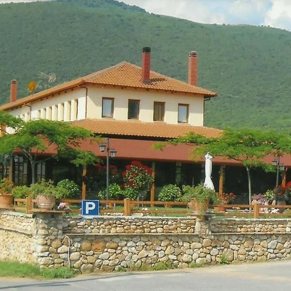 Hotel Kapsalis
Veria
Drive to ski centre: ≈ 16.9 km · 20 min
View on Booking.com ↗
 Lozitsi
Veria
Drive to ski centre: ≈ 22.1 km · 26 min
View on Booking.com ↗
 Veritas Boutique Art Hotel
Veria
Drive to ski centre: ≈ 26.4 km · 31 min
View on Booking.com ↗
Preparing forecast graphs…
Times and values match the detailed forecast. Tap or point at a value for details. Scroll each chart sideways for later days. Rain / precipitation is the total water equivalent per forecast interval, including snow; snowfall is fresh snow per interval, not snow depth.
GFS and ECMWF model comparison. Each model retains its own forecast times and horizon. Precipitation and snowfall amounts cover their own forecast intervals; these can differ between models.
Forecast values and model notes
Seli Ski Area - Alexandros I Top 1750
ECMWF · Model run: Next update expected:
Day Time (UTC) Temp. (°C) Humidity (%) Wind (km/h) Wind (knots) Wind (Bft) Direction Precip. (mm) Snow (cm) Pressure (hPa) Freezing (m) Conditions | Thursday, 05/11 06:00 1.8 100 6 3 2B E — — 1027 2098 Overcast 100% cloud 09:00 1.6 100 5 3 1B E 0.94 0 1028 2046 Overcast 100% cloud 12:00 1.6 100 2 1 1B E 0.85 0 1028 2053 Overcast 100% cloud 15:00 1.7 98 6 3 1B N 0.96 0 1027 2069 Overcast 100% cloud 18:00 1.7 96 7 4 2B N 0.32 0 1027 2102 Overcast 97% cloud 21:00 1.5 95 6 3 2B N 0.06 0 1027 2106 Overcast 99% cloud Friday, 06/11 00:00 1.3 91 4 2 1B N 0 0 1026 2130 Overcast 99% cloud 03:00 1.2 89 5 3 1B N 0 0 1025 2184 Overcast 95% cloud 06:00 1.2 89 6 3 1B N 0.10 0 1025 2227 Overcast 94% cloud 09:00 1.7 85 6 3 2B N 0.31 0 1024 2365 Overcast 93% cloud 12:00 3 75 10 6 2B NW 0.21 0 1022 2540 Cloudy 53% cloud 15:00 3.7 74 12 7 3B NW 0 0 1021 2635 Clear 6% cloud 18:00 4.4 65 15 8 3B NW 0 0 1021 2774 Clear 3% cloud 21:00 4.2 59 14 7 3B N 0 0 1021 2748 Clear 5% cloud Saturday, 07/11 00:00 3.8 58 8 5 2B N 0 0 1022 2657 Clear 5% cloud 03:00 3.1 60 6 3 2B N 0 0 1022 2561 Clear 0% cloud 06:00 2.2 67 4 2 1B NE 0 0 1024 2438 Cloudy 56% cloud 09:00 1.6 73 1 1 1B SE 0 0 1025 2323 Cloudy 63% cloud 12:00 2.1 70 1 1 1B W 0 0 1024 2347 Overcast 97% cloud 15:00 1.9 80 3 1 1B W 0 0 1025 2288 Overcast 92% cloud 18:00 1.6 76 3 1 1B NW 0 0 1026 2204 Cloudy 62% cloud 21:00 1.2 76 2 1 1B E 0 0 1028 2084 Clear 20% cloud Sunday, 08/11 00:00 0.6 80 3 1 1B SE 0 0 1029 1925 Partly cloudy 24% cloud 03:00 0.1 87 5 3 1B SE 0.00 0 1029 1797 Overcast 93% cloud 06:00 0 90 8 4 2B SE 0.02 0 1031 1767 Overcast 95% cloud 09:00 0.1 91 7 4 2B S 0.12 0 1031 1783 Overcast 88% cloud 12:00 0.7 84 4 2 1B SW 0.15 0 1030 1966 Cloudy 73% cloud 15:00 1 84 6 3 1B SW 0.01 0 1030 2050 Partly cloudy 46% cloud 18:00 1.2 74 4 2 1B SW 0 0 1031 2067 Overcast 90% cloud 21:00 1.6 63 3 2 1B W 0 0 1031 2148 Cloudy 73% cloud Monday, 09/11 00:00 1.6 60 4 2 1B SW 0 0 1031 2174 Overcast 87% cloud 03:00 1.9 66 6 3 1B SW 0 0 1030 2211 Overcast 99% cloud 06:00 2.3 72 6 3 2B SW 0.12 0 1030 2276 Overcast 91% cloud 09:00 2.4 78 12 7 2B SW 0.12 0 1030 2301 Overcast 95% cloud 12:00 2.5 87 12 6 2B SW 0.43 0 1028 2318 Overcast 100% cloud 15:00 2.8 92 11 6 2B SW 2.1 0 1027 2392 Overcast 100% cloud 18:00 3.3 88 15 8 3B SW 0.68 0 1027 2455 Overcast 92% cloud 21:00 3.6 87 16 8 3B SW 0 0 1027 2488 Cloudy 61% cloud Tuesday, 10/11 00:00 3.9 89 17 9 3B W 0.10 0 1025 2522 Cloudy 51% cloud 03:00 4.2 87 17 9 3B W 0 0 1024 2579 Partly cloudy 43% cloud 06:00 4.4 83 13 7 3B W 0 0 1024 2705 Clear 6% cloud 09:00 4.8 82 14 7 3B W 0 0 1024 2865 Partly cloudy 21% cloud 12:00 5.1 78 16 9 3B W 0 0 1022 2972 Cloudy 79% cloud 15:00 6 76 18 10 3B W 0 0 1021 3026 Overcast 83% cloud 18:00 6 80 20 11 3B W 0 0 1021 2969 Cloudy 63% cloud 21:00 6.1 80 20 11 4B W 0 0 1020 2948 Overcast 83% cloud Wednesday, 11/11 00:00 6.4 78 21 11 4B W 0 0 1019 2918 Overcast 80% cloud 03:00 6.9 76 22 12 4B W 0 0 1017 2976 Cloudy 73% cloud 06:00 7.1 80 21 11 4B W 0 0 1018 3067 Overcast 90% cloud |
|---|
Forecast notes
Forecast table times: UTC.
Coordinates: 40.53181°N, 22.00628°E · Requested elevation: 1750 m. Model terrain: 1232 m. Terrain and 1000/925/850/700 hPa profiles are used for height estimates.
These are altitude estimates, not a simulation of local mountain terrain. Precipitation, cloud and sea-level pressure use horizontal interpolation only.
Precipitation includes rain and snow water equivalent: preceding 3 hours through day 6, then 6 hours (see cell tooltip). Snow (cm) estimates fresh snowfall from precipitation and temperature using the GFS conversion; it is not snow depth on the ground. Freezing (m) uses additional 600/500 hPa temperatures when available and estimates the lowest resolved 0°C crossing above sea level. When all sampled levels are warm, the upper profile limit is shown (see tooltip). < marks an entirely cold sampled profile and its lower height limit. No extrapolation is used.
Preparing forecast graphs…
Times and values match the detailed forecast. Tap or point at a value for details. Scroll each chart sideways for later days. Rain / precipitation is the total water equivalent per forecast interval, including snow; snowfall is fresh snow per interval, not snow depth.
GFS and ECMWF model comparison. Each model retains its own forecast times and horizon. Precipitation and snowfall amounts cover their own forecast intervals; these can differ between models.
Forecast values and model notes
Seli Ski Area - Iraklis Top 1850
ECMWF · Model run: Next update expected:
Day Time (UTC) Temp. (°C) Humidity (%) Wind (km/h) Wind (knots) Wind (Bft) Direction Precip. (mm) Snow (cm) Pressure (hPa) Freezing (m) Conditions | Thursday, 05/11 06:00 1.3 99 6 3 1B E — — 1027 2100 Overcast 100% cloud 09:00 1.1 100 4 2 1B E 0.98 0.3 1028 2048 Overcast 100% cloud 12:00 1.1 100 1 0 0B NE 0.88 0.3 1028 2054 Overcast 100% cloud 15:00 1.2 98 6 3 2B N 1.0 0 1027 2069 Overcast 100% cloud 18:00 1.2 96 8 4 2B N 0.34 0 1027 2102 Overcast 98% cloud 21:00 1.1 93 7 4 2B N 0.06 0 1027 2106 Overcast 99% cloud Friday, 06/11 00:00 1 88 5 3 1B N 0 0 1026 2129 Overcast 99% cloud 03:00 1 85 7 4 2B N 0 0 1025 2184 Overcast 96% cloud 06:00 1 84 7 4 2B N 0.11 0 1025 2226 Overcast 96% cloud 09:00 1.5 81 7 4 2B N 0.33 0 1024 2367 Overcast 95% cloud 12:00 2.6 72 11 6 2B NW 0.22 0 1022 2540 Cloudy 54% cloud 15:00 3.3 71 13 7 3B NW 0 0 1021 2636 Clear 6% cloud 18:00 3.9 63 16 9 3B N 0 0 1021 2774 Clear 3% cloud 21:00 3.8 58 14 8 3B N 0 0 1021 2747 Clear 6% cloud Saturday, 07/11 00:00 3.3 57 9 5 2B N 0 0 1022 2656 Clear 6% cloud 03:00 2.7 59 7 4 2B N 0 0 1022 2561 Clear 0% cloud 06:00 1.9 66 4 2 1B NE 0 0 1024 2440 Cloudy 57% cloud 09:00 1.4 71 1 1 1B NE 0 0 1025 2323 Cloudy 63% cloud 12:00 1.7 67 2 1 1B NW 0 0 1024 2349 Overcast 98% cloud 15:00 1.5 76 3 2 1B NW 0 0 1025 2289 Overcast 94% cloud 18:00 1.2 72 3 2 1B NW 0 0 1026 2205 Cloudy 64% cloud 21:00 0.8 73 2 1 1B NE 0 0 1028 2082 Partly cloudy 20% cloud Sunday, 08/11 00:00 0.3 77 2 1 1B SE 0 0 1029 1927 Partly cloudy 24% cloud 03:00 -0.2 83 4 2 1B SE 0.00 0 1029 1799 Overcast 96% cloud 06:00 -0.3 85 6 3 2B SE 0.01 0 1031 1770 Overcast 96% cloud 09:00 -0.2 86 6 3 1B S 0.12 0 1031 1787 Overcast 88% cloud 12:00 0.4 79 4 2 1B SW 0.14 0 1030 1972 Cloudy 73% cloud 15:00 0.7 81 6 3 2B W 0.01 0 1030 2051 Partly cloudy 45% cloud 18:00 0.8 72 4 2 1B W 0 0 1031 2068 Overcast 92% cloud 21:00 1.2 62 4 2 1B W 0 0 1031 2149 Cloudy 74% cloud Monday, 09/11 00:00 1.2 59 5 2 1B W 0 0 1031 2172 Overcast 87% cloud 03:00 1.5 67 6 3 1B SW 0 0 1030 2210 Overcast 99% cloud 06:00 1.9 73 6 3 2B SW 0.12 0 1030 2277 Overcast 91% cloud 09:00 2 79 12 6 2B SW 0.12 0 1030 2302 Overcast 95% cloud 12:00 2 87 13 7 3B SW 0.45 0 1028 2320 Overcast 100% cloud 15:00 2.4 93 13 7 3B SW 2.2 0 1027 2393 Overcast 100% cloud 18:00 2.9 88 16 9 3B SW 0.70 0 1027 2458 Overcast 93% cloud 21:00 3.1 86 17 9 3B W 0 0 1027 2489 Cloudy 62% cloud Tuesday, 10/11 00:00 3.4 88 18 10 3B W 0.11 0 1025 2523 Cloudy 52% cloud 03:00 3.7 85 18 10 3B W 0 0 1024 2581 Partly cloudy 44% cloud 06:00 4 82 14 7 3B W 0 0 1024 2705 Clear 6% cloud 09:00 4.4 80 14 8 3B W 0 0 1024 2865 Clear 20% cloud 12:00 4.7 76 17 9 3B W 0 0 1022 2975 Cloudy 78% cloud 15:00 5.5 74 19 10 3B W 0 0 1021 3030 Overcast 83% cloud 18:00 5.5 78 20 11 4B W 0 0 1021 2971 Cloudy 62% cloud 21:00 5.6 79 21 11 4B W 0 0 1020 2948 Overcast 83% cloud Wednesday, 11/11 00:00 5.8 78 22 12 4B W 0 0 1019 2918 Overcast 80% cloud 03:00 6.3 76 23 12 4B W 0 0 1017 2978 Cloudy 72% cloud 06:00 6.5 79 22 12 4B W 0 0 1018 3067 Overcast 90% cloud |
|---|
Forecast notes
Forecast table times: UTC.
Coordinates: 40.520829°N, 22.004521°E · Requested elevation: 1850 m. Model terrain: 1275 m. Terrain and 1000/925/850/700 hPa profiles are used for height estimates.
These are altitude estimates, not a simulation of local mountain terrain. Precipitation, cloud and sea-level pressure use horizontal interpolation only.
Precipitation includes rain and snow water equivalent: preceding 3 hours through day 6, then 6 hours (see cell tooltip). Snow (cm) estimates fresh snowfall from precipitation and temperature using the GFS conversion; it is not snow depth on the ground. Freezing (m) uses additional 600/500 hPa temperatures when available and estimates the lowest resolved 0°C crossing above sea level. When all sampled levels are warm, the upper profile limit is shown (see tooltip). < marks an entirely cold sampled profile and its lower height limit. No extrapolation is used.