Προγνώσεις καιρού για χιονοδρομικά παγκοσμίως

Περισσότερα
Χρωματική κλίμακα Θερμοκρασία · Άνεμος · Βροχή · Χιόνι
Κάθε χρώμα ξεκινά από την τιμή που αναγράφεται. Τα χρώματα ανέμου αντιστοιχούν και στις τρεις μονάδες. Οι τιμές χωρίς υετό παραμένουν ουδέτερες. Τα χρώματα περιγράφουν τις τιμές και δεν αποτελούν επίσημες προειδοποιήσεις.
Προετοιμασία γραφημάτων…
Οι ώρες και οι τιμές αντιστοιχούν στην αναλυτική πρόγνωση. Πατήστε μια τιμή για λεπτομέρειες και μετακινήστε οριζόντια τα γραφήματα για επόμενες ημέρες. Ο υετός είναι το συνολικό ισοδύναμο νερού ανά διάστημα, μαζί με το χιόνι. Η χιονόπτωση αφορά νέο χιόνι ανά διάστημα, όχι το ύψος του χιονιού στο έδαφος.
Σύγκριση GFS και ECMWF. Κάθε μοντέλο διατηρεί τις δικές του ώρες και διάρκεια πρόγνωσης. Ο υετός και το νέο χιόνι αφορούν τα διαστήματα κάθε μοντέλου, τα οποία μπορεί να διαφέρουν.
Τιμές πρόγνωσης και σημειώσεις μοντέλων
Σέλι - Αναβατήρες Baby 1475
ECMWF · Εκτέλεση μοντέλου: Αναμενόμενη επόμενη ενημέρωση:
Ημέρα Ώρα (UTC) Θερμ. (°C) Υγρασία (%) Άνεμος (km/h) Άνεμος (κόμβοι) Άνεμος (Bft) Διεύθυνση Υετός (mm) Νέο χιόνι (cm) Πίεση (hPa) Σημείο παγοποίησης (m) Συνθήκες | Κυριακή, 22/11 06:00 5.2 46 13 7 3B W — — 1020 2421 Clear 7% cloud  09:00 6 52 13 7 3B W 0 0 1020 2663 Cloudy 74% cloud  12:00 6.3 62 18 10 3B SW 0 0 1018 2854 Overcast 84% cloud  15:00 6.5 79 25 13 4B SW 0.87 0 1016 2939 Overcast 94% cloud 18:00 6.4 81 33 18 5B SW 0.10 0 1016 3055 Overcast 95% cloud 21:00 6.8 76 35 19 5B SW 0.10 0 1013 3042 Clear 9% cloud Δευτέρα, 23/11 00:00 8 81 46 25 6B SW 0 0 1009 3021 Partly cloudy 33% cloud  03:00 9 79 55 30 7B SW 0.12 0 1007 3001 Partly cloudy 21% cloud 06:00 7.6 65 58 31 7B W 0 0 1007 2857 Clear 8% cloud 09:00 6.8 70 51 27 7B W 0 0 1007 2603 Clear 12% cloud 12:00 7 56 44 24 6B W 0 0 1007 2455 Partly cloudy 21% cloud 15:00 5.7 69 43 23 6B W 0 0 1010 2332 Clear 12% cloud 18:00 3.9 82 29 16 5B W 0 0 1013 2131 Cloudy 55% cloud 21:00 2.1 96 25 13 4B W 0.10 0 1016 1843 Overcast 86% cloud Τρίτη, 24/11 00:00 0.8 86 22 12 4B W 0 0 1019 1664 Cloudy 64% cloud 03:00 -0.5 84 15 8 3B NW 0 0 1021 < 1183 Partly cloudy 45% cloud 06:00 -1 78 13 7 3B NW 0 0 1024 < 1183 Clear 17% cloud 09:00 -0.4 68 12 6 2B NW 0 0 1025 1442 Clear 10% cloud 12:00 0.7 57 11 6 2B NW 0 0 1024 1559 Clear 3% cloud 15:00 0.4 58 9 5 2B NW 0 0 1026 1586 Clear 2% cloud 18:00 0.5 53 10 5 2B W 0 0 1026 1389 Clear 0% cloud 21:00 0.3 51 8 5 2B W 0 0 1027 1414 Clear 1% cloud Τετάρτη, 25/11 00:00 0.4 45 7 4 2B W 0 0 1027 1357 Clear 9% cloud 03:00 0.5 43 7 4 2B SW 0 0 1026 1284 Partly cloudy 21% cloud 06:00 0.6 47 10 6 2B SW 0 0 1027 1777 Partly cloudy 28% cloud 09:00 1.8 60 13 7 3B SW 0 0 1027 1937 Cloudy 51% cloud 12:00 2.6 61 13 7 3B SW 0 0 1024 2235 Overcast 81% cloud 15:00 2.7 62 14 8 3B SW 0 0 1024 2649 Overcast 83% cloud 18:00 2.8 64 20 11 4B SW 0 0 1023 2788 Cloudy 79% cloud 21:00 3.3 71 23 12 4B SW 0 0 1021 3072 Overcast 92% cloud Πέμπτη, 26/11 00:00 4.2 80 25 13 4B SW 0 0 1019 3072 Overcast 98% cloud 03:00 4.8 84 25 13 4B SW 0.19 0 1018 3063 Overcast 98% cloud 06:00 5.3 85 23 12 4B SW 0.22 0 1017 2833 Overcast 100% cloud 09:00 5 96 25 14 4B S 0.72 0 1018 2703 Overcast 100% cloud 12:00 5.5 96 28 15 4B S 0.75 0 1015 2749 Overcast 100% cloud 15:00 6.2 94 30 16 5B S 0.50 0 1013 2805 Overcast 100% cloud 18:00 6.7 92 27 15 4B S 2.7 0 1013 2806 Overcast 96% cloud 21:00 7.2 89 23 12 4B SW 2.5 0 1012 2768 Overcast 99% cloud Παρασκευή, 27/11 00:00 7.2 91 21 11 4B SW 0.94 0 1012 2723 Overcast 97% cloud 03:00 7.4 87 19 11 3B SW 0.00 0 1011 2686 Overcast 99% cloud 06:00 7 87 19 10 3B SW 0.39 0 1012 2624 Overcast 97% cloud 09:00 7.2 90 20 11 4B SW 0.12 0 1013 2595 Overcast 99% cloud 12:00 7 94 19 10 3B S 1.2 0 1011 2620 Overcast 100% cloud 15:00 6.7 94 23 12 4B S 4.0 0 1010 2626 Overcast 100% cloud 18:00 6.5 90 30 16 5B S 5.9 0 1010 2603 Overcast 100% cloud 21:00 6.2 92 24 13 4B SW 3.0 0 1009 2627 Overcast 100% cloud Σάββατο, 28/11 00:00 5.8 91 19 10 3B S 2.1 0 1009 2509 Overcast 100% cloud 03:00 4.9 97 14 7 3B S 2.2 0 1009 2394 Overcast 100% cloud 06:00 3.8 100 5 3 1B SE 4.9 0 1009 2298 Overcast 100% cloud |
|---|
Forecast notes
Forecast table times: UTC.
Coordinates: 40.54299°N, 22.010196°E · Requested elevation: 1475 m. Model terrain: 1181 m. Terrain and 1000/925/850/700 hPa profiles are used for height estimates.
These are altitude estimates, not a simulation of local mountain terrain. Precipitation, cloud and sea-level pressure use horizontal interpolation only.
Precipitation includes rain and snow water equivalent: preceding 3 hours through day 6, then 6 hours (see cell tooltip). Snow (cm) estimates fresh snowfall from precipitation and temperature using the GFS conversion; it is not snow depth on the ground. Freezing (m) uses additional 600/500 hPa temperatures when available and estimates the lowest resolved 0°C crossing above sea level. When all sampled levels are warm, the upper profile limit is shown (see tooltip). < marks an entirely cold sampled profile and its lower height limit. No extrapolation is used.
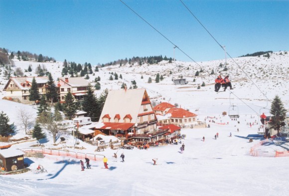
Απέχει 24 χλμ. από τη Βέροια, 20 χλμ. από τη Νάουσα, 95 χλμ. από τη Θεσσαλονίκη και 74 χλμ. από την Κοζάνη. Η κύρια πρόσβαση γίνεται μέσω της Εγνατίας Οδού και της επαρχιακής οδού Βέροιας–Σελίου, ενώ εναλλακτική πρόσβαση προσφέρει η επαρχιακή οδός Νάουσας–Σελίου.
Δείτε τις τρέχουσες χιονοδρομικές συνθήκες στο Snow Report Seli
Διαμονή — Σέλι
Σύρετε για να δείτε και τα 5 καταλύματα →
 Le Bijou Luxury Rooms & Suites
Βέροια
Προς το χιονοδρομικό: ≈ 26,3 km · 31 λεπτά
Δείτε στο Booking.com ↗
 Olganos VL Luxury Rooms & Suites
Βέροια
Προς το χιονοδρομικό: ≈ 25,8 km · 31 λεπτά
Δείτε στο Booking.com ↗
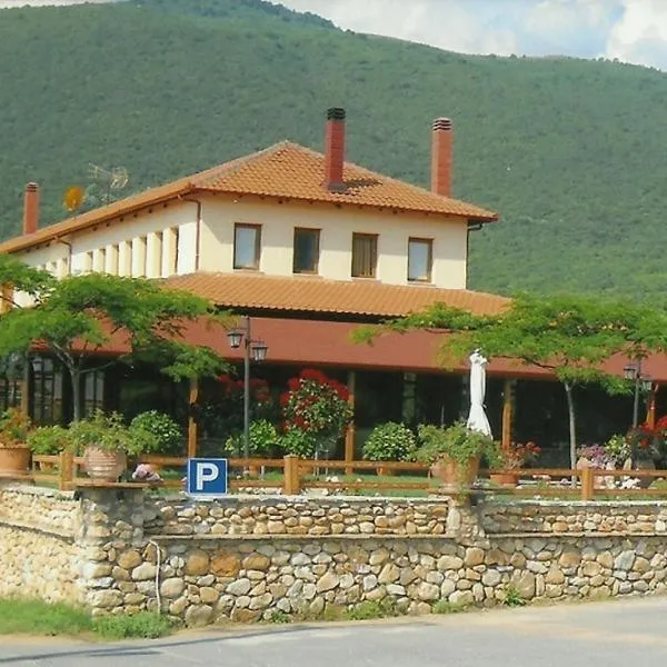 Hotel Kapsalis
Βέροια
Προς το χιονοδρομικό: ≈ 16,9 km · 20 λεπτά
Δείτε στο Booking.com ↗
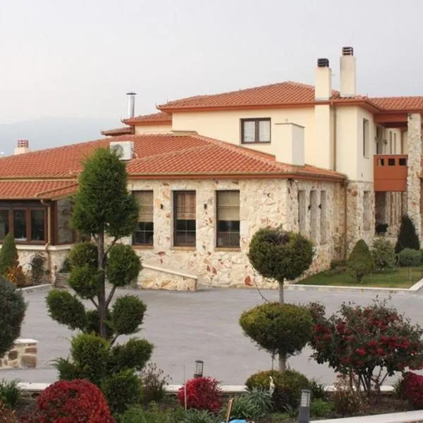 Lozitsi
Βέροια
Προς το χιονοδρομικό: ≈ 22,1 km · 26 λεπτά
Δείτε στο Booking.com ↗
 Veritas Boutique Art Hotel
Βέροια
Προς το χιονοδρομικό: ≈ 26,4 km · 31 λεπτά
Δείτε στο Booking.com ↗
Προετοιμασία γραφημάτων…
Οι ώρες και οι τιμές αντιστοιχούν στην αναλυτική πρόγνωση. Πατήστε μια τιμή για λεπτομέρειες και μετακινήστε οριζόντια τα γραφήματα για επόμενες ημέρες. Ο υετός είναι το συνολικό ισοδύναμο νερού ανά διάστημα, μαζί με το χιόνι. Η χιονόπτωση αφορά νέο χιόνι ανά διάστημα, όχι το ύψος του χιονιού στο έδαφος.
Σύγκριση GFS και ECMWF. Κάθε μοντέλο διατηρεί τις δικές του ώρες και διάρκεια πρόγνωσης. Ο υετός και το νέο χιόνι αφορούν τα διαστήματα κάθε μοντέλου, τα οποία μπορεί να διαφέρουν.
Τιμές πρόγνωσης και σημειώσεις μοντέλων
Σέλι - Κορυφή Αλέξανδρου Ι 1750
ECMWF · Εκτέλεση μοντέλου: Αναμενόμενη επόμενη ενημέρωση:
Ημέρα Ώρα (UTC) Θερμ. (°C) Υγρασία (%) Άνεμος (km/h) Άνεμος (κόμβοι) Άνεμος (Bft) Διεύθυνση Υετός (mm) Νέο χιόνι (cm) Πίεση (hPa) Σημείο παγοποίησης (m) Συνθήκες | Κυριακή, 22/11 06:00 3.9 42 19 10 3B W — — 1020 2425 Clear 7% cloud 09:00 4.4 49 18 10 3B W 0 0 1020 2667 Cloudy 74% cloud 12:00 4.9 58 23 12 4B SW 0 0 1018 2857 Overcast 83% cloud 15:00 5.3 80 30 16 5B W 0.93 0 1016 2939 Overcast 95% cloud 18:00 5.4 81 40 22 6B W 0.10 0 1016 3055 Overcast 95% cloud 21:00 5.8 76 45 24 6B SW 0.10 0 1013 3043 Clear 9% cloud Δευτέρα, 23/11 00:00 6.9 77 54 29 7B SW 0 0 1009 3022 Partly cloudy 34% cloud 03:00 7.5 73 62 33 8B SW 0.12 0 1007 3001 Partly cloudy 21% cloud 06:00 6.1 62 64 35 8B W 0 0 1007 2856 Clear 8% cloud 09:00 5.1 68 58 31 7B W 0 0 1008 2599 Clear 11% cloud 12:00 5 56 51 28 7B W 0 0 1007 2453 Partly cloudy 21% cloud 15:00 3.9 69 47 25 6B W 0 0 1010 2331 Clear 12% cloud 18:00 2.3 81 36 19 5B W 0 0 1013 2138 Cloudy 55% cloud 21:00 0.5 94 31 17 5B W 0.10 0 1016 1846 Overcast 87% cloud Τρίτη, 24/11 00:00 -0.3 76 28 15 4B W 0 0 1019 1669 Cloudy 67% cloud 03:00 -1.5 75 24 13 4B NW 0 0 1021 < 1235 Partly cloudy 46% cloud 06:00 -1.8 69 22 12 4B NW 0 0 1024 < 1235 Clear 18% cloud 09:00 -1.9 63 20 11 4B NW 0 0 1025 1449 Clear 11% cloud 12:00 -0.9 53 19 10 3B NW 0 0 1024 1567 Clear 3% cloud 15:00 -0.8 52 18 10 3B NW 0 0 1026 1591 Clear 2% cloud 18:00 -0.3 47 17 9 3B NW 0 0 1026 1431 Clear 0% cloud 21:00 -0.3 44 15 8 3B W 0 0 1027 1447 Clear 2% cloud Τετάρτη, 25/11 00:00 -0.2 38 13 7 3B W 0 0 1027 1405 Clear 9% cloud 03:00 -0.1 37 12 6 2B W 0 0 1026 1345 Partly cloudy 21% cloud 06:00 0.1 42 13 7 3B SW 0 0 1027 1266 Partly cloudy 27% cloud 09:00 0.6 57 16 9 3B SW 0 0 1027 1942 Cloudy 51% cloud 12:00 1.4 57 17 9 3B SW 0 0 1024 2243 Overcast 81% cloud 15:00 2.2 55 19 10 3B SW 0 0 1024 2657 Overcast 83% cloud 18:00 2.4 61 25 13 4B SW 0 0 1022 2796 Cloudy 79% cloud 21:00 2.8 70 27 15 4B SW 0 0 1021 3074 Overcast 92% cloud Πέμπτη, 26/11 00:00 3.6 79 30 16 5B SW 0 0 1019 3072 Overcast 98% cloud 03:00 4 82 29 16 5B SW 0.21 0 1018 3064 Overcast 98% cloud 06:00 4.3 86 26 14 4B SW 0.23 0 1017 2836 Overcast 100% cloud 09:00 3.9 97 31 17 5B SW 0.69 0 1018 2709 Overcast 100% cloud 12:00 4.4 97 35 19 5B SW 0.75 0 1015 2751 Overcast 100% cloud 15:00 4.9 94 36 20 5B SW 0.50 0 1013 2808 Overcast 100% cloud 18:00 5.4 93 33 18 5B SW 2.8 0 1013 2808 Overcast 96% cloud 21:00 5.7 89 30 16 5B SW 2.5 0 1012 2770 Overcast 99% cloud Παρασκευή, 27/11 00:00 5.6 91 28 15 4B SW 0.98 0 1012 2725 Overcast 97% cloud 03:00 5.7 85 27 15 4B SW 0.00 0 1011 2689 Overcast 99% cloud 06:00 5.3 86 25 14 4B SW 0.42 0 1012 2626 Overcast 97% cloud 09:00 5.4 90 26 14 4B SW 0.12 0 1012 2597 Overcast 100% cloud 12:00 5.3 96 24 13 4B SW 1.2 0 1011 2622 Overcast 100% cloud 15:00 5.1 95 28 15 4B S 4.0 0 1010 2628 Overcast 100% cloud 18:00 4.9 92 34 18 5B SW 6.0 0 1010 2605 Overcast 100% cloud 21:00 4.8 93 28 15 4B SW 3.0 0 1009 2629 Overcast 100% cloud Σάββατο, 28/11 00:00 4.3 93 23 12 4B S 2.2 0 1009 2512 Overcast 100% cloud 03:00 3.5 98 17 9 3B S 2.2 0 1009 2394 Overcast 100% cloud 06:00 2.5 100 8 4 2B S 4.9 0 1009 2298 Overcast 100% cloud |
|---|
Forecast notes
Forecast table times: UTC.
Coordinates: 40.53181°N, 22.00628°E · Requested elevation: 1750 m. Model terrain: 1232 m. Terrain and 1000/925/850/700 hPa profiles are used for height estimates.
These are altitude estimates, not a simulation of local mountain terrain. Precipitation, cloud and sea-level pressure use horizontal interpolation only.
Precipitation includes rain and snow water equivalent: preceding 3 hours through day 6, then 6 hours (see cell tooltip). Snow (cm) estimates fresh snowfall from precipitation and temperature using the GFS conversion; it is not snow depth on the ground. Freezing (m) uses additional 600/500 hPa temperatures when available and estimates the lowest resolved 0°C crossing above sea level. When all sampled levels are warm, the upper profile limit is shown (see tooltip). < marks an entirely cold sampled profile and its lower height limit. No extrapolation is used.
Προετοιμασία γραφημάτων…
Οι ώρες και οι τιμές αντιστοιχούν στην αναλυτική πρόγνωση. Πατήστε μια τιμή για λεπτομέρειες και μετακινήστε οριζόντια τα γραφήματα για επόμενες ημέρες. Ο υετός είναι το συνολικό ισοδύναμο νερού ανά διάστημα, μαζί με το χιόνι. Η χιονόπτωση αφορά νέο χιόνι ανά διάστημα, όχι το ύψος του χιονιού στο έδαφος.
Σύγκριση GFS και ECMWF. Κάθε μοντέλο διατηρεί τις δικές του ώρες και διάρκεια πρόγνωσης. Ο υετός και το νέο χιόνι αφορούν τα διαστήματα κάθε μοντέλου, τα οποία μπορεί να διαφέρουν.
Τιμές πρόγνωσης και σημειώσεις μοντέλων
Σέλι - Κορυφή Ηρακλή 1850
ECMWF · Εκτέλεση μοντέλου: Αναμενόμενη επόμενη ενημέρωση:
Ημέρα Ώρα (UTC) Θερμ. (°C) Υγρασία (%) Άνεμος (km/h) Άνεμος (κόμβοι) Άνεμος (Bft) Διεύθυνση Υετός (mm) Νέο χιόνι (cm) Πίεση (hPa) Σημείο παγοποίησης (m) Συνθήκες | Κυριακή, 22/11 06:00 3.4 41 21 12 4B W — — 1020 2429 Clear 7% cloud 09:00 3.9 47 20 11 3B W 0 0 1020 2670 Cloudy 75% cloud 12:00 4.5 55 25 13 4B SW 0 0 1018 2861 Overcast 82% cloud 15:00 4.9 80 33 18 5B W 0.99 0 1016 2940 Overcast 96% cloud 18:00 5.1 81 43 23 6B W 0.11 0 1016 3055 Overcast 96% cloud 21:00 5.4 76 48 26 6B W 0.11 0 1013 3043 Clear 9% cloud Δευτέρα, 23/11 00:00 6.5 75 58 31 7B SW 0 0 1009 3022 Partly cloudy 35% cloud 03:00 6.9 71 65 35 8B SW 0.12 0 1007 3002 Partly cloudy 21% cloud 06:00 5.6 61 66 36 8B W 0 0 1007 2858 Clear 7% cloud 09:00 4.5 67 61 33 7B W 0 0 1008 2598 Clear 11% cloud 12:00 4.3 56 54 29 7B W 0 0 1007 2453 Partly cloudy 21% cloud 15:00 3.2 68 48 26 6B W 0 0 1010 2330 Clear 12% cloud 18:00 1.8 81 38 21 5B W 0 0 1013 2145 Cloudy 55% cloud 21:00 -0 94 34 18 5B W 0.11 0 1016 1851 Overcast 87% cloud Τρίτη, 24/11 00:00 -0.7 73 31 16 5B W 0 0 1019 1675 Cloudy 69% cloud 03:00 -1.8 71 27 15 4B NW 0 0 1021 < 1278 Partly cloudy 47% cloud 06:00 -2.2 66 26 14 4B NW 0 0 1024 < 1278 Clear 18% cloud 09:00 -2.3 60 23 12 4B NW 0 0 1025 1456 Clear 11% cloud 12:00 -1.4 50 22 12 4B NW 0 0 1024 1574 Clear 3% cloud 15:00 -1.2 49 21 11 4B NW 0 0 1026 1595 Clear 2% cloud 18:00 -0.8 45 20 11 3B NW 0 0 1026 1456 Clear 0% cloud 21:00 -0.8 42 18 10 3B NW 0 0 1027 1468 Clear 2% cloud Τετάρτη, 25/11 00:00 -0.6 36 16 9 3B W 0 0 1027 1435 Clear 9% cloud 03:00 -0.4 36 14 7 3B W 0 0 1026 1384 Partly cloudy 21% cloud 06:00 -0.2 41 15 8 3B W 0 0 1027 1335 Partly cloudy 27% cloud 09:00 0.3 56 17 9 3B SW 0 0 1027 1946 Cloudy 52% cloud 12:00 1.2 55 19 10 3B SW 0 0 1024 2250 Overcast 81% cloud 15:00 2 53 21 11 4B SW 0 0 1024 2665 Overcast 84% cloud 18:00 2.2 60 26 14 4B SW 0 0 1022 2804 Cloudy 79% cloud 21:00 2.7 70 29 16 5B SW 0 0 1021 3075 Overcast 92% cloud Πέμπτη, 26/11 00:00 3.4 78 32 17 5B SW 0 0 1019 3072 Overcast 98% cloud 03:00 3.8 81 31 17 5B SW 0.22 0 1017 3064 Overcast 98% cloud 06:00 3.9 86 28 15 4B SW 0.23 0 1017 2840 Overcast 100% cloud 09:00 3.5 97 34 18 5B SW 0.66 0 1017 2715 Overcast 100% cloud 12:00 4 98 38 20 5B SW 0.74 0 1015 2753 Overcast 100% cloud 15:00 4.5 94 39 21 6B SW 0.49 0 1013 2812 Overcast 100% cloud 18:00 4.9 93 36 19 5B SW 2.9 0 1013 2810 Overcast 96% cloud 21:00 5.2 89 33 18 5B SW 2.5 0 1012 2773 Overcast 99% cloud Παρασκευή, 27/11 00:00 5.1 92 31 17 5B SW 1.0 0 1012 2727 Overcast 97% cloud 03:00 5.1 83 30 16 5B SW 0.00 0 1011 2691 Overcast 99% cloud 06:00 4.7 85 28 15 4B SW 0.44 0 1012 2629 Overcast 97% cloud 09:00 4.8 90 28 15 4B SW 0.12 0 1012 2600 Overcast 100% cloud 12:00 4.7 96 27 14 4B SW 1.3 0 1011 2624 Overcast 100% cloud 15:00 4.6 95 30 16 5B S 4.1 0 1010 2629 Overcast 100% cloud 18:00 4.4 93 36 19 5B SW 6.0 0 1010 2606 Overcast 100% cloud 21:00 4.2 93 29 16 5B SW 3.0 0 1009 2632 Overcast 100% cloud Σάββατο, 28/11 00:00 3.7 93 25 13 4B SW 2.2 0 1009 2514 Overcast 100% cloud 03:00 2.9 98 18 10 3B S 2.2 0 1009 2396 Overcast 100% cloud 06:00 2.1 100 9 5 2B S 4.9 0 1009 2298 Overcast 100% cloud |
|---|
Forecast notes
Forecast table times: UTC.
Coordinates: 40.520829°N, 22.004521°E · Requested elevation: 1850 m. Model terrain: 1275 m. Terrain and 1000/925/850/700 hPa profiles are used for height estimates.
These are altitude estimates, not a simulation of local mountain terrain. Precipitation, cloud and sea-level pressure use horizontal interpolation only.
Precipitation includes rain and snow water equivalent: preceding 3 hours through day 6, then 6 hours (see cell tooltip). Snow (cm) estimates fresh snowfall from precipitation and temperature using the GFS conversion; it is not snow depth on the ground. Freezing (m) uses additional 600/500 hPa temperatures when available and estimates the lowest resolved 0°C crossing above sea level. When all sampled levels are warm, the upper profile limit is shown (see tooltip). < marks an entirely cold sampled profile and its lower height limit. No extrapolation is used.