St. Anton am Arlberg - Valluga · Panorama/video

Provider panorama/video player. Capture time is shown by the camera.
Open camera page ↗
Each colour starts at the value shown. Wind colours match across all three units. Dry cells stay neutral. Colours describe the displayed values, not official weather warnings.
ECMWF · Model run: Next update expected:
Day Local time Temp. (°C) Humidity (%) Wind (km/h) Wind (knots) Wind (Bft) Direction Precip. (mm) Snow (cm) Pressure (hPa) Freezing (m) Conditions | Thursday, 05/11 07:00 -0.1 71 5 3 1B S — — 1023 < 2058 Partly cloudy 22% cloud  10:00 8.4 47 4 2 1B S 0 0 1023 2977 Clear 1% cloud  13:00 11.5 38 2 1 1B SE 0 0 1022 3064 Clear 0% cloud 16:00 9.8 47 1 0 0B S 0 0 1021 3044 Clear 1% cloud 19:00 4.4 54 3 2 1B S 0 0 1022 2777 Clear 0% cloud 22:00 3.2 56 3 1 1B S 0 0 1021 3025 Clear 3% cloud Friday, 06/11 01:00 3.4 55 2 1 1B S 0 0 1020 2774 Clear 2% cloud 04:00 4.2 50 1 1 0B S 0 0 1019 3104 Partly cloudy 31% cloud 07:00 4.3 48 1 0 0B SW 0 0 1019 2825 Overcast 92% cloud  10:00 9.3 40 1 1 0B NW 0 0 1019 3056 Overcast 92% cloud 13:00 8.9 46 3 2 1B NW 0 0 1019 2875 Overcast 98% cloud 16:00 5.9 65 2 1 1B NW 0.22 0 1020 2414 Overcast 94% cloud 19:00 4.1 76 0 0 0B S 0.45 0 1021 < 2058 Overcast 100% cloud 22:00 3.3 78 1 0 0B SW 0.34 0 1022 < 2058 Overcast 100% cloud Saturday, 07/11 01:00 3.3 78 1 1 1B W 0.50 0 1023 < 2058 Overcast 100% cloud 04:00 3.2 78 1 1 0B W 1.3 0 1023 < 2058 Overcast 100% cloud 07:00 2.9 80 1 0 0B N 1.3 0 1024 < 2058 Overcast 100% cloud 10:00 4 75 1 0 0B E 0.98 0 1025 < 2058 Overcast 100% cloud 13:00 5.6 65 1 1 1B SE 0.01 0 1023 2252 Overcast 89% cloud 16:00 4.9 66 2 1 1B N 0.06 0 1023 2177 Cloudy 67% cloud  19:00 1.6 75 2 1 1B S 0 0 1024 < 2058 Clear 16% cloud 22:00 -0.8 73 2 1 1B S 0 0 1024 < 2058 Partly cloudy 43% cloud Sunday, 08/11 01:00 -0.9 75 2 1 1B S 0 0 1024 < 2058 Partly cloudy 38% cloud 04:00 -0.2 72 2 1 1B S 0 0 1024 < 2058 Partly cloudy 34% cloud 07:00 -0.5 71 1 1 1B S 0 0 1024 < 2058 Partly cloudy 28% cloud 10:00 5.2 56 2 1 1B SE 0 0 1024 2218 Clear 7% cloud 13:00 6.9 49 2 1 1B W 0 0 1023 2366 Clear 19% cloud 16:00 4.4 59 1 1 0B NW 0 0 1023 2104 Clear 6% cloud 19:00 -0.2 67 2 1 1B S 0 0 1024 < 2058 Clear 1% cloud 22:00 -0.8 64 2 1 1B S 0 0 1023 < 2058 Clear 0% cloud Monday, 09/11 01:00 -1.2 56 3 1 1B S 0 0 1022 < 2058 Clear 11% cloud 04:00 -1 52 3 1 1B S 0 0 1021 < 2058 Partly cloudy 32% cloud 07:00 0.9 54 4 2 1B S 0 0 1020 < 2058 Overcast 89% cloud 10:00 4.8 54 5 3 1B S 0.06 0 1020 2205 Overcast 90% cloud 13:00 8 41 5 3 1B SW 0 0 1018 2635 Overcast 92% cloud 16:00 6 55 4 2 1B S 0 0 1016 2473 Overcast 98% cloud 19:00 3.7 73 6 3 2B S 0.76 0 1018 < 2058 Overcast 100% cloud 22:00 3.6 75 6 3 2B S 1.1 0 1018 < 2058 Overcast 99% cloud Tuesday, 10/11 01:00 3.4 75 6 4 2B S 1.2 0 1017 < 2058 Overcast 100% cloud 04:00 3.8 76 6 3 2B S 1.5 0 1015 < 2058 Overcast 100% cloud 07:00 4.2 78 6 3 2B S 2.5 0 1015 2077 Overcast 100% cloud 10:00 5.5 76 5 3 1B SW 2.3 0 1015 2434 Overcast 99% cloud 13:00 5.9 77 4 2 1B SW 2.4 0 1015 2520 Overcast 100% cloud 16:00 5.5 78 2 1 1B S 2.3 0 1015 2456 Overcast 100% cloud 19:00 5.4 76 2 1 1B S 0.28 0 1014 2451 Overcast 99% cloud 22:00 6.5 70 2 1 1B SW 0 0 1014 2533 Overcast 99% cloud Wednesday, 11/11 01:00 5.1 71 2 1 1B S 0 0 1013 2412 Partly cloudy 20% cloud 04:00 3.1 73 2 1 1B S 0 0 1012 < 2058 Partly cloudy 43% cloud 07:00 2.7 72 2 1 1B S 0 0 1012 < 2058 Partly cloudy 34% cloud |
|---|
Forecast table times: Europe/Vienna.
Coordinates: 47.13°N, 10.27°E · Requested elevation: 1304 m. Model terrain: 2056 m. Terrain and 1000/925/850/700 hPa profiles are used for height estimates.
Outside the available profile, temperature uses an estimated 5.5°C/km height correction; wind retains the nearest available model-level value. Humidity is estimated with adjusted pressure and temperature.
These are altitude estimates, not a simulation of local mountain terrain. Precipitation, cloud and sea-level pressure use horizontal interpolation only.
Precipitation includes rain and snow water equivalent: preceding 3 hours through day 6, then 6 hours (see cell tooltip). Snow (cm) estimates fresh snowfall from precipitation and temperature using the GFS conversion; it is not snow depth on the ground. Freezing (m) uses additional 600/500 hPa temperatures when available and estimates the lowest resolved 0°C crossing above sea level. When all sampled levels are warm, the upper profile limit is shown (see tooltip). < marks an entirely cold sampled profile and its lower height limit. No extrapolation is used.
Source: ECMWF · CC BY 4.0 · Processed by Snow Report.
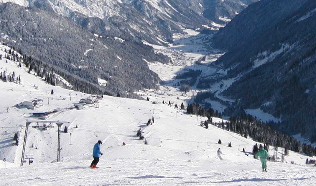
St. Anton is one gateway to Ski Arlberg, the connected ski area linking St. Anton, St. Christoph and Stuben with Lech, Oberlech, Zürs and Warth-Schröcken. A forecast for St. Anton should therefore be read as a forecast for one part of the network, not as a single weather report covering every slope.
The default point on this page is at 1,304 m. That matters during a marginal snowfall event: precipitation at this elevation can fall as rain while higher terrain receives snow. Select the elevation where you intend to ski, then compare the freezing level and temperature with the timing of the precipitation. A large mountain snowfall total does not necessarily describe conditions around your accommodation.
For a day travelling between sectors, check the operator’s piste map and lift status as well as the weather. Compare GFS and ECMWF over the same hours; disagreement is useful information when deciding how much confidence to place in a predicted snowfall. Forecast snow is fresh accumulation, not a measurement of the existing piste base.
Official sources: Ski Arlberg. Reviewed 18 October 2026.
Provider panorama/video player. Capture time is shown by the camera.
Open camera page ↗
Provider panorama/video player. Capture time is shown by the camera.
Open camera page ↗
Provider panorama/video player. Capture time is shown by the camera.
Open camera page ↗ECMWF · Model run: Next update expected:
Day Local time Temp. (°C) Humidity (%) Wind (km/h) Wind (knots) Wind (Bft) Direction Precip. (mm) Snow (cm) Pressure (hPa) Freezing (m) Conditions | Thursday, 05/11 07:00 -4.1 85 6 3 2B S — — 1022 < 2050 Partly cloudy 22% cloud 10:00 4.3 56 4 2 1B S 0 0 1023 2981 Clear 1% cloud 13:00 7.2 46 3 1 1B S 0 0 1022 3062 Clear 0% cloud 16:00 5.5 57 1 1 0B S 0 0 1021 3044 Clear 1% cloud 19:00 0.3 66 3 2 1B S 0 0 1022 2851 Clear 0% cloud 22:00 -0.9 68 3 2 1B S 0 0 1021 3032 Clear 3% cloud Friday, 06/11 01:00 -0.6 66 3 1 1B S 0 0 1020 2738 Clear 2% cloud 04:00 0.2 60 1 1 1B S 0 0 1019 3104 Partly cloudy 35% cloud 07:00 0.3 58 1 0 0B S 0 0 1019 2878 Overcast 95% cloud 10:00 5 48 1 0 0B N 0 0 1019 3050 Overcast 95% cloud 13:00 4.3 57 2 1 1B NW 0 0 1019 2857 Overcast 99% cloud 16:00 1.4 80 1 1 1B NW 0.22 0 1020 2377 Overcast 94% cloud 19:00 -0.3 94 1 1 0B SE 0.49 0.1 1022 < 2050 Overcast 100% cloud 22:00 -1 97 1 1 0B S 0.37 0.1 1022 < 2050 Overcast 100% cloud Saturday, 07/11 01:00 -1 96 2 1 1B W 0.49 0.1 1023 < 2050 Overcast 100% cloud 04:00 -1.1 96 1 1 0B W 1.3 0.4 1023 < 2050 Overcast 100% cloud 07:00 -1.4 98 1 0 0B N 1.3 0.4 1024 < 2050 Overcast 100% cloud 10:00 -0.4 92 1 0 0B SE 0.99 0.3 1025 < 2050 Overcast 100% cloud 13:00 1.2 80 1 1 1B SE 0.01 0 1023 2247 Overcast 88% cloud 16:00 0.6 81 1 1 1B N 0.06 0 1023 2169 Cloudy 66% cloud 19:00 -2.7 92 2 1 1B S 0 0 1024 < 2050 Clear 17% cloud 22:00 -5 89 3 1 1B S 0 0 1024 < 2050 Partly cloudy 42% cloud Sunday, 08/11 01:00 -5 91 2 1 1B S 0 0 1024 < 2050 Partly cloudy 37% cloud 04:00 -4.4 88 2 1 1B S 0 0 1024 < 2050 Partly cloudy 33% cloud 07:00 -4.7 87 1 1 1B S 0 0 1024 < 2050 Partly cloudy 27% cloud 10:00 1 68 2 1 1B SE 0 0 1024 2221 Clear 7% cloud 13:00 2.5 61 3 2 1B W 0 0 1023 2363 Clear 17% cloud 16:00 0.1 72 1 1 1B NW 0 0 1023 2097 Clear 5% cloud 19:00 -4.4 82 2 1 1B S 0 0 1024 < 2050 Clear 1% cloud 22:00 -4.9 77 2 1 1B S 0 0 1023 < 2050 Clear 0% cloud Monday, 09/11 01:00 -5.4 69 3 1 1B S 0 0 1022 < 2050 Clear 12% cloud 04:00 -5.1 64 3 1 1B S 0 0 1021 < 2050 Partly cloudy 34% cloud 07:00 -3.2 66 4 2 1B S 0 0 1020 < 2050 Overcast 89% cloud 10:00 0.6 66 5 3 1B S 0.06 0 1020 2213 Overcast 89% cloud 13:00 3.7 50 6 3 2B SW 0 0 1018 2633 Overcast 92% cloud 16:00 1.8 67 5 2 1B SW 0.00 0 1016 2473 Overcast 99% cloud 19:00 -0.5 91 7 4 2B S 0.81 0.2 1018 < 2050 Overcast 100% cloud 22:00 -0.5 92 6 3 2B S 1.2 0.4 1018 < 2050 Overcast 99% cloud Tuesday, 10/11 01:00 -0.8 92 7 4 2B SW 1.3 0.4 1017 < 2050 Overcast 100% cloud 04:00 -0.4 94 6 3 2B SW 1.5 0.5 1015 < 2050 Overcast 100% cloud 07:00 -0 96 7 4 2B SW 2.7 0.8 1015 2079 Overcast 100% cloud 10:00 1.3 93 5 3 1B SW 2.4 0 1015 2433 Overcast 99% cloud 13:00 1.7 95 4 2 1B SW 2.5 0 1015 2516 Overcast 100% cloud 16:00 1.3 96 2 1 1B SW 2.2 0 1015 2457 Overcast 100% cloud 19:00 1.2 93 2 1 1B SW 0.25 0 1014 2453 Overcast 99% cloud 22:00 2.2 86 2 1 1B SW 0 0 1014 2535 Overcast 98% cloud Wednesday, 11/11 01:00 0.9 86 2 1 1B S 0 0 1013 2414 Clear 19% cloud 04:00 -1 89 2 1 1B S 0 0 1012 < 2050 Partly cloudy 41% cloud 07:00 -1.3 87 2 1 1B S 0 0 1012 < 2050 Partly cloudy 34% cloud |
|---|
Forecast table times: Europe/Vienna.
Coordinates: 47.1308393°N, 10.2307545°E · Requested elevation: 2079 m. Model terrain: 2048 m. Terrain and 1000/925/850/700 hPa profiles are used for height estimates.
These are altitude estimates, not a simulation of local mountain terrain. Precipitation, cloud and sea-level pressure use horizontal interpolation only.
Precipitation includes rain and snow water equivalent: preceding 3 hours through day 6, then 6 hours (see cell tooltip). Snow (cm) estimates fresh snowfall from precipitation and temperature using the GFS conversion; it is not snow depth on the ground. Freezing (m) uses additional 600/500 hPa temperatures when available and estimates the lowest resolved 0°C crossing above sea level. When all sampled levels are warm, the upper profile limit is shown (see tooltip). < marks an entirely cold sampled profile and its lower height limit. No extrapolation is used.
Source: ECMWF · CC BY 4.0 · Processed by Snow Report.
ECMWF · Model run: Next update expected:
Day Time (UTC) Temp. (°C) Humidity (%) Wind (km/h) Wind (knots) Wind (Bft) Direction Precip. (mm) Snow (cm) Pressure (hPa) Freezing (m) Conditions | Thursday, 05/11 06:00 -1.9 41 17 9 3B S — — 1022 < 1977 Clear 18% cloud 09:00 0.9 39 15 8 3B S 0 0 1023 2992 Clear 1% cloud 12:00 1.9 39 14 8 3B S 0 0 1022 3068 Clear 0% cloud 15:00 1.4 44 10 6 2B S 0 0 1021 3048 Clear 1% cloud 18:00 0.2 45 9 5 2B S 0 0 1022 3005 Clear 0% cloud 21:00 -0.1 48 7 4 2B S 0 0 1021 2978 Clear 4% cloud Friday, 06/11 00:00 0.2 46 8 4 2B S 0 0 1020 2308 Clear 2% cloud 03:00 0.3 44 7 4 2B S 0 0 1019 3104 Partly cloudy 35% cloud 06:00 0.1 45 11 6 2B SE 0 0 1019 2970 Overcast 94% cloud 09:00 1.2 39 14 7 3B SE 0 0 1019 3053 Overcast 95% cloud 12:00 0.2 49 17 9 3B SE 0 0 1019 2850 Overcast 99% cloud 15:00 -2.1 72 20 11 4B SE 0.19 0 1021 2352 Overcast 95% cloud 18:00 -2.8 82 21 11 4B SE 0.44 0.1 1022 2000 Overcast 100% cloud 21:00 -3.5 93 13 7 3B S 0.39 0.4 1023 < 1977 Overcast 100% cloud Saturday, 07/11 00:00 -4 98 9 5 2B S 0.52 0.5 1023 < 1977 Overcast 100% cloud 03:00 -4.6 97 6 3 1B S 1.4 1.4 1023 < 1977 Overcast 100% cloud 06:00 -4.9 97 1 1 1B S 1.4 1.4 1024 < 1977 Overcast 100% cloud 09:00 -4.7 96 4 2 1B SE 1.0 1 1025 1996 Overcast 100% cloud 12:00 -4.1 88 9 5 2B S 0.02 0 1023 2235 Overcast 87% cloud 15:00 -4.2 79 13 7 3B S 0.07 0.1 1023 2161 Cloudy 70% cloud 18:00 -4.7 73 12 6 2B S 0 0 1024 < 1977 Clear 19% cloud 21:00 -5.1 67 11 6 2B S 0 0 1024 < 1977 Partly cloudy 33% cloud Sunday, 08/11 00:00 -5.1 66 5 3 1B SW 0 0 1024 < 1977 Partly cloudy 31% cloud 03:00 -5.6 73 4 2 1B W 0 0 1024 < 1977 Partly cloudy 27% cloud 06:00 -6 76 1 1 1B S 0 0 1024 < 1977 Partly cloudy 22% cloud 09:00 -4.1 66 7 4 2B S 0 0 1024 2223 Clear 5% cloud 12:00 -3.9 68 10 6 2B SW 0 0 1023 2364 Clear 19% cloud 15:00 -4.6 66 7 4 2B W 0 0 1023 2115 Clear 5% cloud 18:00 -5.6 52 9 5 2B W 0 0 1024 < 1977 Clear 1% cloud 21:00 -5.8 52 16 8 3B W 0 0 1023 < 1977 Clear 0% cloud Monday, 09/11 00:00 -5.8 67 17 9 3B W 0 0 1022 < 1977 Clear 14% cloud 03:00 -5.4 71 21 11 4B W 0 0 1021 < 1977 Partly cloudy 35% cloud 06:00 -4.4 68 20 11 4B SW 0 0 1020 < 1977 Overcast 89% cloud 09:00 -2.7 75 30 16 5B SW 0.08 0 1020 2228 Overcast 89% cloud 12:00 -1.2 62 32 17 5B SW 0 0 1017 2638 Overcast 92% cloud 15:00 -1.5 75 37 20 5B W 0.01 0 1016 2489 Overcast 99% cloud 18:00 -2 93 43 23 6B W 0.86 0.3 1018 < 1977 Overcast 100% cloud 21:00 -1.9 96 44 24 6B W 1.2 0.4 1018 < 1977 Overcast 100% cloud Tuesday, 10/11 00:00 -1.8 96 41 22 6B W 1.5 0.4 1017 < 1977 Overcast 100% cloud 03:00 -1.8 97 40 22 6B W 1.8 0.5 1015 1991 Overcast 100% cloud 06:00 -1.6 98 35 19 5B W 3.0 0.9 1015 2136 Overcast 100% cloud 09:00 -1.3 97 27 15 4B W 2.6 0.8 1015 2431 Overcast 100% cloud 12:00 -1.1 98 27 15 4B W 2.7 0.8 1015 2518 Overcast 100% cloud 15:00 -1.2 98 21 11 4B W 2.4 0.7 1015 2451 Overcast 100% cloud 18:00 -1.1 97 23 12 4B W 0.28 0.1 1014 2462 Overcast 99% cloud 21:00 -1.4 96 16 9 3B W 0 0 1014 2521 Overcast 98% cloud Wednesday, 11/11 00:00 -1 90 13 7 3B NW 0 0 1013 2432 Partly cloudy 20% cloud 03:00 -0.9 83 12 7 2B W 0 0 1012 < 1977 Partly cloudy 31% cloud 06:00 -0.6 70 13 7 3B W 0 0 1012 < 1977 Partly cloudy 26% cloud |
|---|
Forecast table times: UTC.
Coordinates: 47.1575711°N, 10.2130106°E · Requested elevation: 2805 m. Model terrain: 1974 m. Terrain and 1000/925/850/700 hPa profiles are used for height estimates.
These are altitude estimates, not a simulation of local mountain terrain. Precipitation, cloud and sea-level pressure use horizontal interpolation only.
Precipitation includes rain and snow water equivalent: preceding 3 hours through day 6, then 6 hours (see cell tooltip). Snow (cm) estimates fresh snowfall from precipitation and temperature using the GFS conversion; it is not snow depth on the ground. Freezing (m) uses additional 600/500 hPa temperatures when available and estimates the lowest resolved 0°C crossing above sea level. When all sampled levels are warm, the upper profile limit is shown (see tooltip). < marks an entirely cold sampled profile and its lower height limit. No extrapolation is used.
Source: ECMWF · CC BY 4.0 · Processed by Snow Report.
ECMWF · Model run: Next update expected:
Day Local time Temp. (°C) Humidity (%) Wind (km/h) Wind (knots) Wind (Bft) Direction Precip. (mm) Snow (cm) Pressure (hPa) Freezing (m) Conditions | Thursday, 05/11 07:00 -0.3 71 5 3 1B S — — 1023 < 2066 Partly cloudy 22% cloud 10:00 8.1 48 4 2 1B S 0 0 1023 2977 Clear 1% cloud 13:00 11.2 38 2 1 1B SE 0 0 1022 3063 Clear 0% cloud 16:00 9.5 48 1 0 0B S 0 0 1021 3044 Clear 1% cloud 19:00 4.1 55 3 2 1B S 0 0 1022 2720 Clear 0% cloud 22:00 3 57 3 1 1B S 0 0 1021 3030 Clear 3% cloud Friday, 06/11 01:00 3.2 56 2 1 1B S 0 0 1020 2788 Clear 2% cloud 04:00 3.9 51 1 1 0B S 0 0 1019 3104 Partly cloudy 32% cloud 07:00 4.1 48 1 0 0B SW 0 0 1019 2808 Overcast 92% cloud 10:00 9.1 40 1 1 0B NW 0 0 1019 3055 Overcast 92% cloud 13:00 8.6 46 3 2 1B NW 0 0 1019 2874 Overcast 98% cloud 16:00 5.7 65 2 1 1B NW 0.22 0 1020 2413 Overcast 93% cloud 19:00 3.8 77 0 0 0B SE 0.46 0 1021 < 2066 Overcast 100% cloud 22:00 3 79 1 0 0B SW 0.34 0 1022 < 2066 Overcast 100% cloud Saturday, 07/11 01:00 3.1 79 1 1 1B W 0.50 0 1023 < 2066 Overcast 100% cloud 04:00 2.9 79 1 1 0B W 1.3 0 1023 < 2066 Overcast 100% cloud 07:00 2.6 80 1 0 0B N 1.3 0 1024 < 2066 Overcast 100% cloud 10:00 3.7 75 1 0 0B E 0.98 0 1025 < 2066 Overcast 100% cloud 13:00 5.3 66 1 1 1B SE 0.01 0 1023 2253 Overcast 89% cloud 16:00 4.7 66 2 1 1B N 0.06 0 1023 2177 Cloudy 67% cloud 19:00 1.3 76 2 1 1B S 0 0 1024 < 2066 Clear 16% cloud 22:00 -1.1 74 2 1 1B S 0 0 1024 < 2066 Partly cloudy 44% cloud Sunday, 08/11 01:00 -1.1 76 2 1 1B S 0 0 1024 < 2066 Partly cloudy 39% cloud 04:00 -0.5 73 2 1 1B S 0 0 1024 < 2066 Partly cloudy 34% cloud 07:00 -0.7 71 1 1 1B S 0 0 1024 < 2066 Partly cloudy 29% cloud 10:00 5 57 2 1 1B SE 0 0 1024 2219 Clear 7% cloud 13:00 6.6 50 3 1 1B W 0 0 1023 2366 Clear 18% cloud 16:00 4.2 59 1 1 0B NW 0 0 1023 2101 Clear 6% cloud 19:00 -0.5 68 2 1 1B S 0 0 1024 < 2066 Clear 1% cloud 22:00 -1 64 2 1 1B S 0 0 1023 < 2066 Clear 0% cloud Monday, 09/11 01:00 -1.5 57 3 1 1B S 0 0 1022 < 2066 Clear 11% cloud 04:00 -1.2 52 3 1 1B S 0 0 1021 < 2066 Partly cloudy 32% cloud 07:00 0.6 54 4 2 1B S 0 0 1020 < 2066 Overcast 88% cloud 10:00 4.6 55 5 3 1B S 0.06 0 1020 2204 Overcast 90% cloud 13:00 7.7 42 5 3 1B SW 0 0 1018 2634 Overcast 92% cloud 16:00 5.8 55 4 2 1B S 0 0 1016 2470 Overcast 98% cloud 19:00 3.4 74 6 3 2B S 0.76 0 1018 < 2066 Overcast 100% cloud 22:00 3.4 76 6 3 2B S 1.1 0 1018 < 2066 Overcast 99% cloud Tuesday, 10/11 01:00 3.1 76 7 4 2B S 1.2 0 1017 < 2066 Overcast 100% cloud 04:00 3.5 77 6 3 2B S 1.5 0 1015 < 2066 Overcast 100% cloud 07:00 3.9 79 6 3 2B S 2.5 0 1015 2069 Overcast 100% cloud 10:00 5.3 77 5 3 1B SW 2.3 0 1015 2434 Overcast 99% cloud 13:00 5.7 78 4 2 1B SW 2.4 0 1015 2519 Overcast 100% cloud 16:00 5.3 79 2 1 1B S 2.2 0 1015 2457 Overcast 100% cloud 19:00 5.2 77 2 1 1B S 0.27 0 1014 2450 Overcast 98% cloud 22:00 6.3 71 2 1 1B SW 0 0 1014 2536 Overcast 99% cloud Wednesday, 11/11 01:00 4.9 72 2 1 1B S 0 0 1013 2411 Partly cloudy 20% cloud 04:00 2.8 74 2 1 1B S 0 0 1012 < 2066 Partly cloudy 44% cloud 07:00 2.4 73 2 1 1B S 0 0 1012 < 2066 Partly cloudy 35% cloud |
|---|
Forecast table times: Europe/Vienna.
Coordinates: 47.1274°N, 10.2674°E · Requested elevation: 1347 m. Model terrain: 2063 m. Terrain and 1000/925/850/700 hPa profiles are used for height estimates.
Outside the available profile, temperature uses an estimated 5.5°C/km height correction; wind retains the nearest available model-level value. Humidity is estimated with adjusted pressure and temperature.
These are altitude estimates, not a simulation of local mountain terrain. Precipitation, cloud and sea-level pressure use horizontal interpolation only.
Precipitation includes rain and snow water equivalent: preceding 3 hours through day 6, then 6 hours (see cell tooltip). Snow (cm) estimates fresh snowfall from precipitation and temperature using the GFS conversion; it is not snow depth on the ground. Freezing (m) uses additional 600/500 hPa temperatures when available and estimates the lowest resolved 0°C crossing above sea level. When all sampled levels are warm, the upper profile limit is shown (see tooltip). < marks an entirely cold sampled profile and its lower height limit. No extrapolation is used.