Worldwide Ski Resort Forecasts

More
Colour guide Temperature · Wind · Rain · Snow
Each colour starts at the value shown. Wind colours match across all three units. Dry cells stay neutral. Colours describe the displayed values, not official weather warnings.
SkiWelt Wilder Kaiser - Brixental - Low lift station
ECMWF · Model run: Next update expected:
Day Time (UTC) Temp. (°C) Humidity (%) Wind (km/h) Wind (knots) Wind (Bft) Direction Precip. (mm) Snow (cm) Pressure (hPa) Freezing (m) Conditions | Thursday, 05/11 06:00 1 75 3 2 1B SE — — 1026 < 1139 Partly cloudy 33% cloud  09:00 8.7 56 0 0 0B SE 0 0 1025 2843 Clear 13% cloud  12:00 14 41 1 1 1B NE 0 0 1023 3073 Clear 0% cloud 15:00 12 54 1 1 0B N 0 0 1021 3123 Clear 0% cloud 18:00 6.4 65 1 0 0B S 0 0 1023 3127 Clear 4% cloud 21:00 3.4 66 2 1 1B S 0 0 1023 3126 Clear 7% cloud Friday, 06/11 00:00 2.6 63 2 1 1B S 0 0 1022 1988 Clear 9% cloud 03:00 2.6 58 1 1 0B S 0 0 1021 2166 Clear 2% cloud 06:00 2 59 1 0 0B S 0 0 1021 3009 Clear 7% cloud 09:00 9.3 46 2 1 1B N 0 0 1022 3103 Clear 4% cloud 12:00 12.1 46 3 2 1B N 0 0 1020 3096 Clear 0% cloud 15:00 7.8 65 4 2 1B N 0 0 1021 2928 Partly cloudy 33% cloud 18:00 4.1 80 1 0 0B E 0 0 1023 2068 Overcast 99% cloud  21:00 3.5 81 2 1 1B SE 0 0 1024 1573 Overcast 95% cloud Saturday, 07/11 00:00 3.2 79 1 0 0B SE 0 0 1024 1292 Overcast 89% cloud 03:00 3.2 77 0 0 0B E 0 0 1025 1246 Overcast 94% cloud 06:00 3.5 78 0 0 0B SE 0.10 0 1026 1334 Overcast 99% cloud 09:00 6.9 70 1 0 0B NW 0.14 0 1026 1990 Overcast 95% cloud 12:00 10.2 57 3 1 1B N 0 0 1024 2359 Partly cloudy 22% cloud 15:00 8.6 67 3 1 1B N 0 0 1023 2277 Clear 3% cloud 18:00 4.2 76 0 0 0B S 0 0 1025 1618 Clear 1% cloud 21:00 2.2 75 1 1 1B S 0 0 1025 < 1139 Clear 12% cloud Sunday, 08/11 00:00 1.6 71 2 1 1B S 0 0 1025 < 1139 Partly cloudy 30% cloud 03:00 2 66 1 1 1B SW 0 0 1025 < 1139 Partly cloudy 26% cloud 06:00 1.5 65 1 0 0B SW 0 0 1025 < 1139 Partly cloudy 22% cloud 09:00 8.5 46 1 0 0B W 0 0 1025 2111 Clear 9% cloud 12:00 12.1 41 1 1 1B N 0 0 1022 2358 Clear 1% cloud 15:00 9.6 60 3 1 1B N 0 0 1022 2106 Partly cloudy 37% cloud 18:00 4.9 73 1 0 0B S 0 0 1024 1559 Clear 15% cloud 21:00 2.5 73 2 1 1B S 0 0 1024 < 1139 Partly cloudy 30% cloud Monday, 09/11 00:00 1.9 73 2 1 1B S 0 0 1024 < 1139 Partly cloudy 31% cloud 03:00 0.9 74 2 1 1B S 0 0 1023 < 1139 Partly cloudy 25% cloud 06:00 0.3 72 3 1 1B S 0 0 1022 < 1139 Partly cloudy 25% cloud 09:00 9 50 0 0 0B S 0 0 1021 2187 Cloudy 79% cloud  12:00 11.7 42 1 0 0B S 0 0 1018 2424 Overcast 99% cloud 15:00 9.8 54 1 0 0B NE 0 0 1016 2393 Overcast 100% cloud 18:00 7.9 65 1 1 0B SW 0.58 0 1017 2266 Overcast 100% cloud 21:00 6.7 77 3 2 1B S 0.94 0 1017 2157 Overcast 100% cloud Tuesday, 10/11 00:00 6.4 81 4 2 1B S 2.2 0 1017 2106 Overcast 100% cloud 03:00 6.4 83 4 2 1B S 2.8 0 1015 2150 Overcast 100% cloud 06:00 6.7 82 2 1 1B S 3.2 0 1015 2194 Overcast 100% cloud 09:00 8.2 82 1 1 1B SW 1.7 0 1015 2366 Overcast 100% cloud 12:00 9.3 82 0 0 0B N 0.38 0 1014 2449 Overcast 100% cloud 15:00 8.7 82 1 0 0B E 0.13 0 1015 2422 Overcast 100% cloud 18:00 8.1 83 1 1 0B E 0.07 0 1015 2367 Overcast 90% cloud 21:00 7.9 82 1 0 0B SE 0.03 0 1016 2413 Overcast 100% cloud Wednesday, 11/11 00:00 7.8 80 1 1 1B S 0.02 0 1015 2359 Cloudy 61% cloud 03:00 6 81 1 1 0B S 0 0 1014 2335 Partly cloudy 34% cloud 06:00 5.3 78 1 1 1B SW 0 0 1014 2307 Partly cloudy 28% cloud |
|---|
Forecast notes
Forecast table times: UTC.
Coordinates: 47.4455787°N, 12.1609094°E · Requested elevation: 609 m. Model terrain: 1137 m. Terrain and 1000/925/850/700 hPa profiles are used for height estimates.
Outside the available profile, temperature uses an estimated 5.5°C/km height correction; wind retains the nearest available model-level value. Humidity is estimated with adjusted pressure and temperature.
These are altitude estimates, not a simulation of local mountain terrain. Precipitation, cloud and sea-level pressure use horizontal interpolation only.
Precipitation includes rain and snow water equivalent: preceding 3 hours through day 6, then 6 hours (see cell tooltip). Snow (cm) estimates fresh snowfall from precipitation and temperature using the GFS conversion; it is not snow depth on the ground. Freezing (m) uses additional 600/500 hPa temperatures when available and estimates the lowest resolved 0°C crossing above sea level. When all sampled levels are warm, the upper profile limit is shown (see tooltip). < marks an entirely cold sampled profile and its lower height limit. No extrapolation is used.
Source: ECMWF · CC BY 4.0 · Processed by Snow Report.
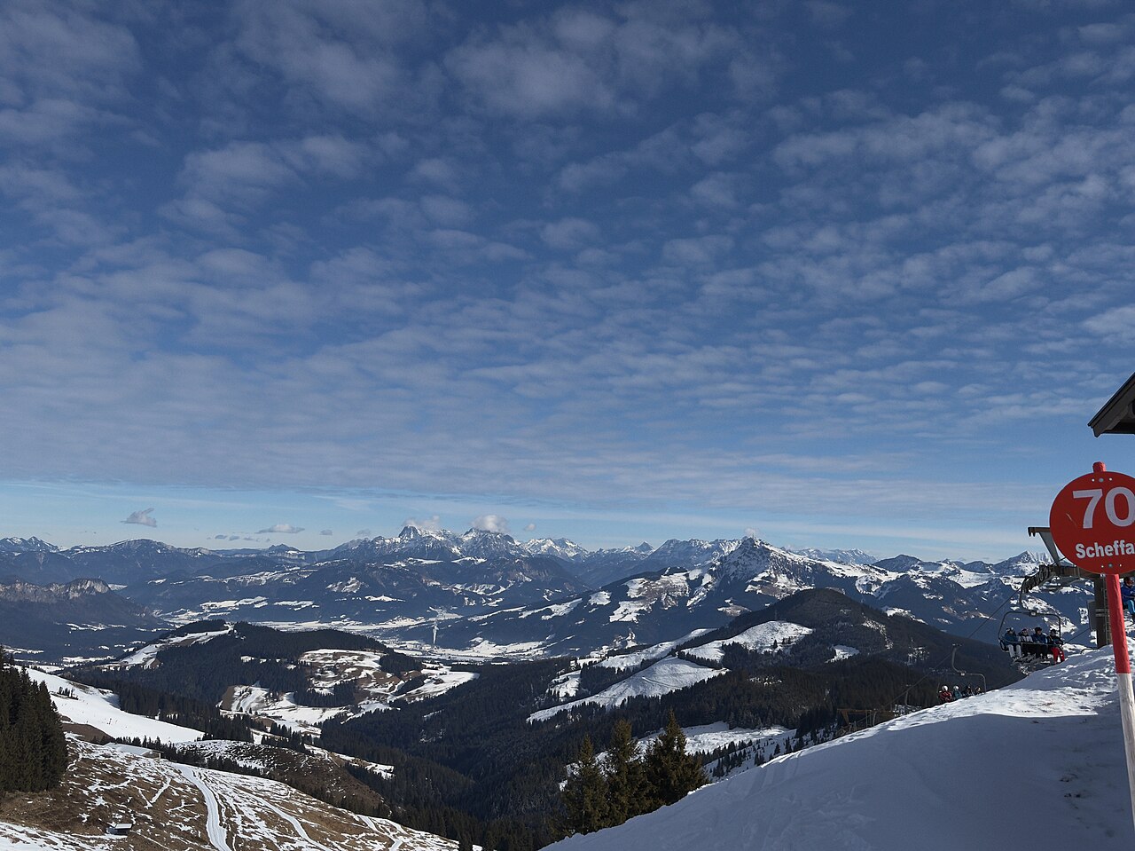
SkiWelt Wilder Kaiser - Brixental is a downhill ski area in Tyrol, Austria. Mapped terrain includes beginner, easy, intermediate, advanced, freeride routes. Its mapped lift network extends from approximately 609 to 1865 metres above sea level.
Data: OpenSkiData / OpenSkiMap, OpenStreetMap contributors (ODbL), Skimap.org, Who's On First, Mapterhorn.
SkiWelt Wilder Kaiser - Brixental - Base lift station
ECMWF · Model run: Next update expected:
Day Time (UTC) Temp. (°C) Humidity (%) Wind (km/h) Wind (knots) Wind (Bft) Direction Precip. (mm) Snow (cm) Pressure (hPa) Freezing (m) Conditions | Thursday, 05/11 06:00 -0.3 76 5 3 1B SE — — 1025 < 1125 Clear 18% cloud 09:00 7.8 56 2 1 1B E 0 0 1025 2832 Clear 8% cloud 12:00 12.9 42 1 1 1B NE 0 0 1023 3079 Clear 0% cloud 15:00 11.1 57 1 1 1B N 0 0 1021 3123 Clear 0% cloud 18:00 5.4 69 1 0 0B S 0 0 1023 3127 Clear 5% cloud 21:00 1.8 69 3 2 1B SE 0 0 1023 1471 Clear 10% cloud Friday, 06/11 00:00 1 64 2 1 1B S 0 0 1022 2468 Clear 13% cloud 03:00 1.2 59 1 1 1B SE 0 0 1022 2488 Clear 4% cloud 06:00 0.6 59 1 1 1B SE 0 0 1021 3029 Clear 11% cloud 09:00 8 48 2 1 1B N 0 0 1022 3103 Clear 5% cloud 12:00 10.6 50 4 2 1B N 0 0 1020 3096 Clear 0% cloud 15:00 6.4 69 4 2 1B NW 0 0 1021 2937 Partly cloudy 29% cloud 18:00 2.7 84 0 0 0B SW 0 0 1024 1956 Overcast 99% cloud 21:00 2.3 85 3 1 1B SE 0 0 1024 1486 Overcast 96% cloud Saturday, 07/11 00:00 1.8 83 1 1 0B SE 0 0 1024 1133 Overcast 84% cloud 03:00 1.8 79 0 0 0B SE 0 0 1025 < 1125 Overcast 91% cloud 06:00 2.1 80 0 0 0B SE 0.05 0 1026 1236 Overcast 99% cloud 09:00 5.7 71 0 0 0B N 0.10 0 1026 1988 Overcast 96% cloud 12:00 9 60 3 2 1B N 0 0 1024 2357 Clear 8% cloud 15:00 7.4 71 2 1 1B N 0 0 1023 2274 Clear 1% cloud 18:00 3.3 78 1 0 0B S 0 0 1025 1655 Clear 0% cloud 21:00 1 77 2 1 1B S 0 0 1025 < 1125 Clear 12% cloud Sunday, 08/11 00:00 0.1 72 2 1 1B S 0 0 1025 < 1125 Clear 12% cloud 03:00 0.6 66 1 1 1B S 0 0 1025 < 1125 Clear 11% cloud 06:00 0.1 66 1 1 0B SE 0 0 1025 < 1125 Clear 12% cloud 09:00 7.4 45 0 0 0B NW 0 0 1025 2099 Clear 8% cloud 12:00 10.9 43 2 1 1B N 0 0 1022 2366 Clear 2% cloud 15:00 8.5 63 2 1 1B N 0 0 1022 2094 Cloudy 52% cloud 18:00 3.9 74 1 0 0B S 0 0 1024 1559 Clear 17% cloud 21:00 1.3 74 3 1 1B S 0 0 1024 < 1125 Clear 12% cloud Monday, 09/11 00:00 0.4 74 3 1 1B S 0 0 1024 < 1125 Clear 13% cloud 03:00 -0.6 75 3 2 1B S 0 0 1023 < 1125 Clear 11% cloud 06:00 -1.3 74 3 2 1B S 0 0 1022 < 1125 Clear 13% cloud 09:00 8.1 50 1 1 1B SE 0 0 1021 2192 Cloudy 76% cloud 12:00 10.7 42 1 0 0B SW 0 0 1018 2410 Overcast 99% cloud 15:00 8.8 55 0 0 0B N 0 0 1016 2387 Overcast 100% cloud 18:00 6.8 67 1 1 0B SW 0.42 0 1017 2253 Overcast 100% cloud 21:00 5.6 83 4 2 1B S 0.79 0 1017 2129 Overcast 100% cloud Tuesday, 10/11 00:00 5.2 87 5 3 1B S 1.9 0 1016 2068 Overcast 100% cloud 03:00 5.3 89 4 2 1B S 2.4 0 1015 2131 Overcast 100% cloud 06:00 5.5 88 2 1 1B S 2.9 0 1015 2166 Overcast 100% cloud 09:00 7.1 88 1 0 0B S 1.7 0 1015 2353 Overcast 100% cloud 12:00 8.1 86 1 0 0B N 0.39 0 1014 2434 Overcast 100% cloud 15:00 7.6 85 1 0 0B E 0.10 0 1015 2415 Overcast 100% cloud 18:00 7.1 87 1 1 0B E 0.05 0 1015 2366 Overcast 87% cloud 21:00 6.9 85 1 1 1B SE 0.05 0 1016 2404 Overcast 100% cloud Wednesday, 11/11 00:00 7 83 1 1 1B S 0.00 0 1015 2379 Partly cloudy 47% cloud 03:00 5.3 83 1 1 1B S 0 0 1014 2376 Clear 14% cloud 06:00 4.3 80 1 1 1B S 0 0 1014 2291 Clear 11% cloud |
|---|
Forecast notes
Forecast table times: UTC.
Coordinates: 47.4489567°N, 12.2439273°E · Requested elevation: 791 m. Model terrain: 1122 m. Terrain and 1000/925/850/700 hPa profiles are used for height estimates.
Outside the available profile, temperature uses an estimated 5.5°C/km height correction; wind retains the nearest available model-level value. Humidity is estimated with adjusted pressure and temperature.
These are altitude estimates, not a simulation of local mountain terrain. Precipitation, cloud and sea-level pressure use horizontal interpolation only.
Precipitation includes rain and snow water equivalent: preceding 3 hours through day 6, then 6 hours (see cell tooltip). Snow (cm) estimates fresh snowfall from precipitation and temperature using the GFS conversion; it is not snow depth on the ground. Freezing (m) uses additional 600/500 hPa temperatures when available and estimates the lowest resolved 0°C crossing above sea level. When all sampled levels are warm, the upper profile limit is shown (see tooltip). < marks an entirely cold sampled profile and its lower height limit. No extrapolation is used.
Source: ECMWF · CC BY 4.0 · Processed by Snow Report.
SkiWelt Wilder Kaiser - Brixental - Top lift station
ECMWF · Model run: Next update expected:
Day Time (UTC) Temp. (°C) Humidity (%) Wind (km/h) Wind (knots) Wind (Bft) Direction Precip. (mm) Snow (cm) Pressure (hPa) Freezing (m) Conditions | Thursday, 05/11 06:00 -2.5 64 7 4 2B S — — 1025 < 1287 Clear 13% cloud 09:00 3.8 50 3 2 1B S 0 0 1024 2858 Clear 6% cloud 12:00 7.1 40 3 2 1B S 0 0 1023 3077 Clear 0% cloud 15:00 5.7 51 2 1 1B S 0 0 1021 3123 Clear 0% cloud 18:00 1.7 56 4 2 1B S 0 0 1023 3127 Clear 4% cloud 21:00 -0.2 51 5 2 1B S 0 0 1023 2350 Clear 8% cloud Friday, 06/11 00:00 -0.3 45 4 2 1B S 0 0 1022 2373 Clear 11% cloud 03:00 -0.2 44 3 2 1B S 0 0 1021 2439 Clear 3% cloud 06:00 -0.6 44 3 2 1B SE 0 0 1020 3014 Clear 9% cloud 09:00 4.5 38 4 2 1B SE 0 0 1021 3103 Clear 4% cloud 12:00 5.9 43 4 2 1B S 0 0 1020 3096 Clear 0% cloud 15:00 2.8 58 4 2 1B S 0 0 1020 2905 Partly cloudy 27% cloud 18:00 0 66 7 4 2B SE 0 0 1023 1876 Overcast 99% cloud 21:00 -0.7 66 9 5 2B SE 0 0 1023 < 1287 Overcast 94% cloud Saturday, 07/11 00:00 -1.2 66 8 5 2B SE 0 0 1024 < 1287 Overcast 84% cloud 03:00 -1.6 70 9 5 2B SE 0 0 1024 < 1287 Overcast 92% cloud 06:00 -1.7 81 10 5 2B SE 0.09 0 1025 1323 Overcast 99% cloud 09:00 0.7 78 9 5 2B SE 0.07 0 1026 2015 Overcast 91% cloud 12:00 2.9 63 9 5 2B SE 0 0 1023 2356 Clear 13% cloud 15:00 1.8 67 8 4 2B SE 0 0 1023 2232 Clear 1% cloud 18:00 -1 68 10 6 2B S 0 0 1024 1474 Clear 0% cloud 21:00 -2.5 68 11 6 2B S 0 0 1025 < 1287 Clear 9% cloud Sunday, 08/11 00:00 -2.9 70 12 6 2B S 0 0 1025 < 1287 Clear 9% cloud 03:00 -2.6 63 9 5 2B S 0 0 1024 < 1287 Clear 8% cloud 06:00 -3.3 66 5 3 1B S 0 0 1025 < 1287 Clear 9% cloud 09:00 1.6 51 5 3 1B S 0 0 1025 2141 Clear 6% cloud 12:00 3.8 51 4 2 1B S 0 0 1022 2371 Clear 2% cloud 15:00 1.5 73 5 2 1B SW 0 0 1022 2091 Cloudy 52% cloud 18:00 -1.6 80 4 2 1B W 0 0 1024 1518 Clear 15% cloud 21:00 -3.1 75 4 2 1B W 0 0 1024 < 1287 Clear 9% cloud Monday, 09/11 00:00 -3.5 66 6 3 2B W 0 0 1024 < 1287 Clear 9% cloud 03:00 -4 71 8 4 2B W 0 0 1022 < 1287 Clear 8% cloud 06:00 -4.2 74 9 5 2B W 0 0 1022 < 1287 Clear 10% cloud 09:00 2.4 56 9 5 2B W 0 0 1020 2258 Cloudy 78% cloud 12:00 4.1 49 10 5 2B SW 0 0 1018 2442 Overcast 98% cloud 15:00 2.9 62 12 7 3B SW 0 0 1016 2399 Overcast 100% cloud 18:00 1.5 76 15 8 3B W 0.35 0 1017 2228 Overcast 100% cloud 21:00 0.9 90 16 8 3B W 0.71 0.2 1017 2127 Overcast 100% cloud Tuesday, 10/11 00:00 0.7 95 13 7 3B W 1.8 0.5 1016 2069 Overcast 100% cloud 03:00 0.9 97 16 9 3B W 2.3 0.7 1015 2132 Overcast 100% cloud 06:00 1.1 96 16 9 3B W 2.9 0.9 1015 2178 Overcast 100% cloud 09:00 2.2 95 15 8 3B W 1.6 0 1015 2375 Overcast 100% cloud 12:00 2.9 94 14 8 3B W 0.53 0 1014 2459 Overcast 100% cloud 15:00 2.5 94 13 7 3B W 0.19 0 1014 2421 Overcast 100% cloud 18:00 2.1 94 11 6 2B NW 0.09 0 1015 2373 Overcast 89% cloud 21:00 2.1 93 11 6 2B W 0.09 0 1015 2404 Overcast 100% cloud Wednesday, 11/11 00:00 2.1 89 9 5 2B W 0.00 0 1015 2383 Cloudy 59% cloud 03:00 1.4 79 7 4 2B W 0 0 1013 2371 Clear 10% cloud 06:00 0.7 80 6 3 2B W 0 0 1014 2237 Clear 8% cloud |
|---|
Forecast notes
Forecast table times: UTC.
Coordinates: 47.4028167°N, 12.2498809°E · Requested elevation: 1865 m. Model terrain: 1285 m. Terrain and 1000/925/850/700 hPa profiles are used for height estimates.
These are altitude estimates, not a simulation of local mountain terrain. Precipitation, cloud and sea-level pressure use horizontal interpolation only.
Precipitation includes rain and snow water equivalent: preceding 3 hours through day 6, then 6 hours (see cell tooltip). Snow (cm) estimates fresh snowfall from precipitation and temperature using the GFS conversion; it is not snow depth on the ground. Freezing (m) uses additional 600/500 hPa temperatures when available and estimates the lowest resolved 0°C crossing above sea level. When all sampled levels are warm, the upper profile limit is shown (see tooltip). < marks an entirely cold sampled profile and its lower height limit. No extrapolation is used.