SNOWREPORT
METEOCAM
Worldwide Ski Resort Forecasts
GFS, ECMWF & ICON weather models
Up to 16-day outlook
2,272 ski resorts Newest resort: Moose Mountain Ski Resort ↗
125 snow cams Newest camera: Skeetawk ↗
Mountain weather expertise since 1996

More
Colour guide Temperature · Wind · Rain · Snow
Temperature °C< −10 / −10 / 0 / 10 / 20 / 30+
Wind km/h< 10 / 10 / 29 / 50 / 75+
Rain mm< 1 / 1 / 3 / 10 / 20+
Snow cm< 1 / 1 / 5 / 10 / 20+
Each colour starts at the value shown. Wind colours match across all three units. Dry cells stay neutral. Colours describe the displayed values, not official weather warnings.
Preparing forecast graphs…
Times and values match the detailed forecast. Tap or point at a value for details. Scroll each chart sideways for later days. Rain / precipitation is the total water equivalent per forecast interval, including snow; snowfall is fresh snow per interval, not snow depth.
GFS and ECMWF model comparison. Each model retains its own forecast times and horizon. Precipitation and snowfall amounts cover their own forecast intervals; these can differ between models.
Forecast values and model notes
Saalbach - base 1000 m
ECMWF · Model run: Next update expected:
Day Time (UTC) Temp. (°C) Humidity (%) Wind (km/h) Wind (knots) Wind (Bft) Direction Precip. (mm) Snow (cm) Pressure (hPa) Freezing (m) Conditions | Thursday, 05/11 06:00 -1.3 78 6 3 1B S — — 1025 < 1428 Partly cloudy 42% cloud  09:00 7.5 57 4 2 1B SE 0 0 1025 2950 Clear 7% cloud  12:00 12.3 41 3 1 1B SE 0 0 1023 3094 Clear 4% cloud 15:00 9.8 54 2 1 1B SE 0 0 1022 3124 Clear 1% cloud 18:00 4.3 61 3 2 1B S 0 0 1022 3127 Clear 1% cloud 21:00 3 62 3 2 1B S 0 0 1022 3126 Clear 0% cloud Friday, 06/11 00:00 2.6 56 3 2 1B S 0 0 1021 3118 Clear 0% cloud 03:00 2.4 53 3 2 1B S 0 0 1020 3111 Clear 0% cloud 06:00 2.1 51 3 1 1B S 0 0 1020 2504 Clear 0% cloud 09:00 10.2 41 1 0 0B S 0 0 1020 3105 Clear 0% cloud 12:00 12.7 38 2 1 1B N 0 0 1018 3097 Clear 0% cloud 15:00 8.2 59 2 1 1B NW 0 0 1019 3063 Clear 4% cloud 18:00 2.5 74 1 0 0B SW 0 0 1022 1607 Cloudy 77% cloud  21:00 1.2 77 2 1 1B S 0 0 1023 < 1428 Cloudy 73% cloud Saturday, 07/11 00:00 0.4 76 2 1 1B S 0 0 1023 < 1428 Cloudy 78% cloud 03:00 0.4 73 1 1 1B S 0 0 1023 < 1428 Cloudy 62% cloud 06:00 0.9 74 1 0 0B S 0.05 0 1024 < 1428 Cloudy 77% cloud 09:00 5.6 63 0 0 0B — 0.08 0 1025 2114 Cloudy 66% cloud 12:00 8.8 53 2 1 1B N 0.03 0 1023 2456 Clear 13% cloud 15:00 6.7 64 2 1 1B N 0 0 1023 2312 Clear 3% cloud 18:00 1.9 72 1 1 1B S 0 0 1024 < 1428 Clear 1% cloud 21:00 0.8 67 3 1 1B S 0 0 1025 < 1428 Clear 0% cloud Sunday, 08/11 00:00 0.4 61 4 2 1B S 0 0 1024 < 1428 Clear 0% cloud 03:00 0.3 57 3 2 1B S 0 0 1023 < 1428 Clear 0% cloud 06:00 0.4 55 3 1 1B S 0 0 1024 < 1428 Clear 0% cloud 09:00 7.7 37 1 1 1B S 0 0 1024 2248 Clear 0% cloud 12:00 10.2 35 1 0 0B N 0 0 1022 2422 Clear 3% cloud 15:00 7.1 56 2 1 1B N 0 0 1022 2097 Clear 14% cloud 18:00 3.3 67 1 0 0B S 0 0 1024 1616 Partly cloudy 22% cloud 21:00 1.2 69 2 1 1B S 0 0 1024 < 1428 Clear 6% cloud Monday, 09/11 00:00 0.6 68 3 2 1B S 0 0 1023 < 1428 Clear 0% cloud 03:00 0.2 66 4 2 1B S 0 0 1022 < 1428 Clear 0% cloud 06:00 0.4 61 4 2 1B S 0 0 1021 < 1428 Clear 0% cloud 09:00 8.6 39 4 2 1B SE 0 0 1020 2328 Partly cloudy 35% cloud 12:00 10.9 35 3 2 1B S 0 0 1017 2503 Overcast 98% cloud  15:00 7.9 51 0 0 0B S 0 0 1016 2422 Overcast 100% cloud 18:00 5.5 63 3 1 1B SW 0.15 0 1016 2216 Overcast 100% cloud 21:00 5.1 73 3 2 1B S 0.42 0 1017 2175 Overcast 100% cloud Tuesday, 10/11 00:00 4.6 80 4 2 1B S 1.4 0 1017 2077 Overcast 100% cloud 03:00 4.6 81 3 2 1B S 1.5 0 1015 2114 Overcast 100% cloud 06:00 4.8 83 3 2 1B S 2.3 0 1015 2164 Overcast 100% cloud 09:00 6.3 83 2 1 1B S 1.3 0 1015 2348 Overcast 100% cloud 12:00 7.1 85 1 0 0B S 0.56 0 1014 2434 Overcast 100% cloud 15:00 6.8 85 1 0 0B W 0.37 0 1014 2401 Overcast 100% cloud 18:00 6.3 84 0 0 0B — 0.18 0 1015 2346 Overcast 99% cloud 21:00 6.1 83 1 1 0B S 0 0 1015 2354 Overcast 91% cloud Wednesday, 11/11 00:00 6 83 2 1 1B SE 0 0 1015 2367 Overcast 86% cloud 03:00 5.3 81 3 2 1B SE 0 0 1013 2384 Clear 11% cloud 06:00 3.6 80 3 2 1B S 0 0 1013 2164 Clear 14% cloud |
|---|
Forecast notes
Forecast table times: UTC.
Coordinates: 47.38905261°N, 12.63479233°E · Requested elevation: 1000 m. Model terrain: 1425 m. Terrain and 1000/925/850/700 hPa profiles are used for height estimates.
Outside the available profile, temperature uses an estimated 5.5°C/km height correction; wind retains the nearest available model-level value. Humidity is estimated with adjusted pressure and temperature.
These are altitude estimates, not a simulation of local mountain terrain. Precipitation, cloud and sea-level pressure use horizontal interpolation only.
Precipitation includes rain and snow water equivalent: preceding 3 hours through day 6, then 6 hours (see cell tooltip). Snow (cm) estimates fresh snowfall from precipitation and temperature using the GFS conversion; it is not snow depth on the ground. Freezing (m) uses additional 600/500 hPa temperatures when available and estimates the lowest resolved 0°C crossing above sea level. When all sampled levels are warm, the upper profile limit is shown (see tooltip). < marks an entirely cold sampled profile and its lower height limit. No extrapolation is used.
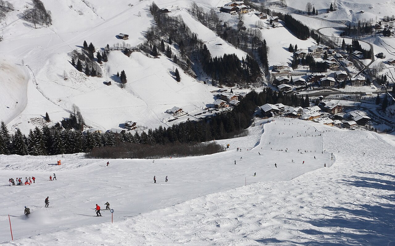
Between 22 January and 3 February 1991, the FIS Alpine World Ski Championships took place in Saalbach-Hinterglemm.It has also been the venue for the British University Snowsports Championships (BUSC) and the British Royal Air Force Championships on several occasions with great success.
Resort cameras
Preparing forecast graphs…
Times and values match the detailed forecast. Tap or point at a value for details. Scroll each chart sideways for later days. Rain / precipitation is the total water equivalent per forecast interval, including snow; snowfall is fresh snow per interval, not snow depth.
GFS and ECMWF model comparison. Each model retains its own forecast times and horizon. Precipitation and snowfall amounts cover their own forecast intervals; these can differ between models.
Forecast values and model notes
Saalbach - middle 1557 m
ECMWF · Model run: Next update expected:
Day Time (UTC) Temp. (°C) Humidity (%) Wind (km/h) Wind (knots) Wind (Bft) Direction Precip. (mm) Snow (cm) Pressure (hPa) Freezing (m) Conditions | Thursday, 05/11 06:00 -3.7 82 5 3 1B S — — 1025 < 1444 Partly cloudy 41% cloud 09:00 4.7 61 4 2 1B SE 0 0 1025 2949 Clear 7% cloud 12:00 9.1 44 3 2 1B SE 0 0 1023 3093 Clear 4% cloud 15:00 6.9 58 2 1 1B SE 0 0 1022 3124 Clear 1% cloud 18:00 1.7 64 3 2 1B S 0 0 1022 3127 Clear 1% cloud 21:00 0.6 64 3 2 1B S 0 0 1022 3126 Clear 0% cloud Friday, 06/11 00:00 0.3 58 3 2 1B S 0 0 1021 3118 Clear 0% cloud 03:00 0.1 54 3 2 1B S 0 0 1020 3111 Clear 0% cloud 06:00 -0.2 52 3 1 1B S 0 0 1020 2469 Clear 0% cloud 09:00 7.3 43 2 1 1B SE 0 0 1020 3104 Clear 0% cloud 12:00 9.6 41 1 0 0B NE 0 0 1018 3097 Clear 0% cloud 15:00 5.5 62 1 1 0B NW 0 0 1019 3058 Clear 4% cloud 18:00 0.1 77 2 1 1B S 0 0 1021 1678 Cloudy 79% cloud 21:00 -1.2 80 3 2 1B S 0 0 1023 < 1444 Cloudy 71% cloud Saturday, 07/11 00:00 -2 79 4 2 1B S 0 0 1023 < 1444 Cloudy 77% cloud 03:00 -2 78 3 1 1B S 0 0 1023 < 1444 Cloudy 64% cloud 06:00 -1.6 81 3 2 1B SE 0.06 0 1024 < 1444 Cloudy 78% cloud 09:00 2.6 71 2 1 1B SE 0.09 0 1025 2113 Cloudy 67% cloud 12:00 5.7 58 1 1 1B E 0.03 0 1023 2453 Clear 13% cloud 15:00 3.7 69 1 1 0B SE 0 0 1023 2306 Clear 3% cloud 18:00 -0.8 76 4 2 1B S 0 0 1024 < 1444 Clear 1% cloud 21:00 -1.8 72 5 2 1B S 0 0 1025 < 1444 Clear 0% cloud Sunday, 08/11 00:00 -2.1 67 5 3 1B S 0 0 1024 < 1444 Clear 0% cloud 03:00 -2.3 62 4 2 1B S 0 0 1023 < 1444 Clear 0% cloud 06:00 -2.2 60 3 2 1B S 0 0 1024 < 1444 Clear 0% cloud 09:00 4.5 42 2 1 1B S 0 0 1024 2252 Clear 0% cloud 12:00 6.9 40 1 0 0B S 0 0 1022 2423 Clear 4% cloud 15:00 3.8 63 1 1 1B NW 0 0 1022 2097 Clear 15% cloud 18:00 0.3 75 1 1 1B SW 0 0 1023 1617 Partly cloudy 22% cloud 21:00 -1.6 77 2 1 1B S 0 0 1024 < 1444 Clear 6% cloud Monday, 09/11 00:00 -2.2 73 2 1 1B S 0 0 1023 < 1444 Clear 0% cloud 03:00 -2.5 71 3 2 1B S 0 0 1022 < 1444 Clear 0% cloud 06:00 -2.3 68 3 2 1B S 0 0 1021 < 1444 Clear 0% cloud 09:00 5.4 44 3 2 1B S 0 0 1020 2336 Partly cloudy 37% cloud 12:00 7.6 40 4 2 1B S 0 0 1017 2509 Overcast 98% cloud 15:00 4.8 58 3 1 1B SW 0 0 1016 2424 Overcast 100% cloud 18:00 2.6 71 5 2 1B SW 0.15 0 1016 2215 Overcast 100% cloud 21:00 2.3 82 4 2 1B SW 0.42 0 1017 2177 Overcast 100% cloud Tuesday, 10/11 00:00 1.8 90 4 2 1B SW 1.4 0 1017 2082 Overcast 100% cloud 03:00 1.9 91 4 2 1B SW 1.5 0 1015 2122 Overcast 100% cloud 06:00 2.1 93 3 2 1B SW 2.3 0 1015 2172 Overcast 100% cloud 09:00 3.4 93 3 2 1B SW 1.2 0 1015 2356 Overcast 100% cloud 12:00 4.2 95 3 2 1B W 0.55 0 1014 2440 Overcast 100% cloud 15:00 3.8 95 4 2 1B W 0.37 0 1014 2404 Overcast 100% cloud 18:00 3.5 94 3 1 1B NW 0.19 0 1015 2349 Overcast 99% cloud 21:00 3.3 92 2 1 1B W 0 0 1015 2359 Overcast 90% cloud Wednesday, 11/11 00:00 3.2 91 2 1 1B SW 0 0 1015 2370 Overcast 86% cloud 03:00 2.6 87 2 1 1B S 0 0 1013 2385 Clear 10% cloud 06:00 1.1 86 2 1 1B S 0 0 1013 2175 Clear 13% cloud |
|---|
Forecast notes
Forecast table times: UTC.
Coordinates: 47.37591839°N, 12.63462067°E · Requested elevation: 1557 m. Model terrain: 1442 m. Terrain and 1000/925/850/700 hPa profiles are used for height estimates.
These are altitude estimates, not a simulation of local mountain terrain. Precipitation, cloud and sea-level pressure use horizontal interpolation only.
Precipitation includes rain and snow water equivalent: preceding 3 hours through day 6, then 6 hours (see cell tooltip). Snow (cm) estimates fresh snowfall from precipitation and temperature using the GFS conversion; it is not snow depth on the ground. Freezing (m) uses additional 600/500 hPa temperatures when available and estimates the lowest resolved 0°C crossing above sea level. When all sampled levels are warm, the upper profile limit is shown (see tooltip). < marks an entirely cold sampled profile and its lower height limit. No extrapolation is used.
Preparing forecast graphs…
Times and values match the detailed forecast. Tap or point at a value for details. Scroll each chart sideways for later days. Rain / precipitation is the total water equivalent per forecast interval, including snow; snowfall is fresh snow per interval, not snow depth.
GFS and ECMWF model comparison. Each model retains its own forecast times and horizon. Precipitation and snowfall amounts cover their own forecast intervals; these can differ between models.
Forecast values and model notes
Saalbach - top 2084 m
ECMWF · Model run: Next update expected:
Day Time (UTC) Temp. (°C) Humidity (%) Wind (km/h) Wind (knots) Wind (Bft) Direction Precip. (mm) Snow (cm) Pressure (hPa) Freezing (m) Conditions | Thursday, 05/11 06:00 -3 59 6 3 1B S — — 1025 < 1459 Partly cloudy 40% cloud 09:00 2.9 51 4 2 1B S 0 0 1025 2943 Clear 7% cloud 12:00 6 40 4 2 1B S 0 0 1023 3091 Clear 4% cloud 15:00 4.6 48 3 1 1B SE 0 0 1022 3124 Clear 1% cloud 18:00 1.1 48 4 2 1B S 0 0 1022 3127 Clear 1% cloud 21:00 0.4 47 4 2 1B S 0 0 1022 3126 Clear 0% cloud Friday, 06/11 00:00 0.2 42 4 2 1B S 0 0 1021 3118 Clear 0% cloud 03:00 0.1 40 3 2 1B S 0 0 1020 1849 Clear 0% cloud 06:00 -0.2 39 3 2 1B SE 0 0 1019 2699 Clear 0% cloud 09:00 4.9 35 6 3 2B SE 0 0 1020 3104 Clear 0% cloud 12:00 6.4 36 6 3 2B SE 0 0 1018 3097 Clear 0% cloud 15:00 3.6 50 5 3 1B S 0 0 1018 3051 Clear 4% cloud 18:00 -0.3 57 7 4 2B SE 0 0 1021 1726 Overcast 82% cloud 21:00 -1.4 57 10 5 2B SE 0 0 1023 < 1459 Cloudy 71% cloud Saturday, 07/11 00:00 -2.3 59 11 6 2B S 0 0 1023 < 1459 Cloudy 76% cloud 03:00 -2.7 64 10 5 2B SE 0 0 1023 < 1459 Cloudy 66% cloud 06:00 -2.7 73 12 7 2B SE 0.07 0 1024 < 1459 Overcast 80% cloud 09:00 0.1 74 13 7 3B SE 0.10 0 1025 2110 Cloudy 70% cloud 12:00 2.3 54 11 6 2B SE 0.03 0 1023 2449 Clear 14% cloud 15:00 1.1 59 10 6 2B SE 0 0 1023 2299 Clear 3% cloud 18:00 -1.8 61 13 7 3B S 0 0 1024 < 1459 Clear 1% cloud 21:00 -2.7 63 13 7 3B S 0 0 1025 < 1459 Clear 0% cloud Sunday, 08/11 00:00 -2.9 61 13 7 3B S 0 0 1024 < 1459 Clear 0% cloud 03:00 -2.9 55 11 6 2B S 0 0 1023 < 1459 Clear 0% cloud 06:00 -3.3 57 7 4 2B S 0 0 1024 < 1459 Clear 0% cloud 09:00 1.1 46 6 3 2B S 0 0 1024 2255 Clear 0% cloud 12:00 2.7 46 6 3 2B S 0 0 1022 2423 Clear 4% cloud 15:00 0.1 69 5 3 1B SW 0 0 1022 2097 Clear 15% cloud 18:00 -2.3 78 5 3 1B W 0 0 1023 1616 Partly cloudy 22% cloud 21:00 -3.6 77 5 2 1B W 0 0 1024 < 1459 Clear 5% cloud Monday, 09/11 00:00 -3.8 62 5 3 1B W 0 0 1023 < 1459 Clear 0% cloud 03:00 -4 62 9 5 2B W 0 0 1022 < 1459 Clear 0% cloud 06:00 -3.7 68 10 5 2B W 0 0 1021 < 1459 Clear 0% cloud 09:00 1.8 50 10 5 2B W 0 0 1020 2342 Partly cloudy 40% cloud 12:00 3.4 46 10 6 2B SW 0 0 1017 2513 Overcast 98% cloud 15:00 1.9 60 13 7 3B W 0 0 1016 2426 Overcast 100% cloud 18:00 0.5 74 15 8 3B W 0.15 0 1016 2212 Overcast 100% cloud 21:00 0.3 86 18 10 3B W 0.43 0.1 1017 2176 Overcast 100% cloud Tuesday, 10/11 00:00 -0 92 15 8 3B W 1.4 0.4 1017 2086 Overcast 100% cloud 03:00 0.1 93 18 10 3B W 1.5 0.5 1015 2128 Overcast 100% cloud 06:00 0.3 94 18 10 3B W 2.3 0.7 1015 2179 Overcast 100% cloud 09:00 1.2 94 17 9 3B W 1.2 0 1015 2366 Overcast 100% cloud 12:00 1.7 96 16 9 3B W 0.54 0 1014 2446 Overcast 100% cloud 15:00 1.5 97 16 9 3B W 0.37 0 1014 2406 Overcast 100% cloud 18:00 1.2 95 14 8 3B NW 0.19 0 1015 2350 Overcast 99% cloud 21:00 1.1 93 14 8 3B W 0 0 1015 2362 Overcast 90% cloud Wednesday, 11/11 00:00 1.1 89 12 6 2B W 0 0 1015 2369 Overcast 86% cloud 03:00 0.9 74 8 4 2B W 0 0 1013 2378 Clear 10% cloud 06:00 0.1 75 7 4 2B W 0 0 1013 2154 Clear 11% cloud |
|---|
Forecast notes
Forecast table times: UTC.
Coordinates: 47.36429245°N, 12.62329102°E · Requested elevation: 2084 m. Model terrain: 1456 m. Terrain and 1000/925/850/700 hPa profiles are used for height estimates.
These are altitude estimates, not a simulation of local mountain terrain. Precipitation, cloud and sea-level pressure use horizontal interpolation only.
Precipitation includes rain and snow water equivalent: preceding 3 hours through day 6, then 6 hours (see cell tooltip). Snow (cm) estimates fresh snowfall from precipitation and temperature using the GFS conversion; it is not snow depth on the ground. Freezing (m) uses additional 600/500 hPa temperatures when available and estimates the lowest resolved 0°C crossing above sea level. When all sampled levels are warm, the upper profile limit is shown (see tooltip). < marks an entirely cold sampled profile and its lower height limit. No extrapolation is used.