Worldwide Ski Resort Forecasts

More
Colour guide Temperature · Wind · Rain · Snow
Each colour starts at the value shown. Wind colours match across all three units. Dry cells stay neutral. Colours describe the displayed values, not official weather warnings.
Prati di Tivo - Low lift station
ECMWF · Model run: Next update expected:
Day Time (UTC) Temp. (°C) Humidity (%) Wind (km/h) Wind (knots) Wind (Bft) Direction Precip. (mm) Snow (cm) Pressure (hPa) Freezing (m) Conditions | Thursday, 05/11 06:00 3.4 91 6 3 2B E — — 1027 2589 Overcast 92% cloud  09:00 4.9 87 7 4 2B E 0.01 0 1027 2730 Cloudy 60% cloud  12:00 6.6 80 5 3 1B E 0.03 0 1026 2909 Overcast 81% cloud 15:00 5.8 89 4 2 1B E 0.03 0 1025 3000 Cloudy 62% cloud 18:00 4.4 93 3 1 1B E 0.01 0 1026 3098 Overcast 93% cloud 21:00 4.7 80 3 1 1B E 0.03 0 1026 3130 Overcast 89% cloud Friday, 06/11 00:00 4.9 69 3 2 1B S 0 0 1024 3079 Cloudy 73% cloud 03:00 4.6 71 2 1 1B SE 0 0 1023 3082 Overcast 80% cloud 06:00 4.6 65 2 1 1B S 0 0 1023 2961 Overcast 86% cloud 09:00 7.8 64 3 2 1B SE 0 0 1022 3065 Overcast 93% cloud 12:00 7.4 82 3 1 1B SE 0.47 0 1021 2955 Overcast 100% cloud 15:00 6.8 93 8 4 2B SE 4.3 0 1020 2959 Overcast 100% cloud 18:00 6.4 93 5 3 1B S 1.1 0 1021 2830 Overcast 100% cloud 21:00 6.6 96 5 3 1B SW 0.11 0 1020 2788 Cloudy 70% cloud Saturday, 07/11 00:00 6.2 97 5 3 1B SW 0 0 1020 2653 Cloudy 52% cloud 03:00 6 96 5 3 1B SW 0 0 1020 2591 Overcast 89% cloud 06:00 5.5 95 5 3 1B SW 0 0 1020 2483 Overcast 91% cloud 09:00 7.1 88 4 2 1B W 0.09 0 1021 2469 Partly cloudy 31% cloud  12:00 7.8 72 2 1 1B NW 0.86 0 1020 2448 Cloudy 54% cloud 15:00 6.7 84 3 2 1B N 0.84 0 1021 2418 Cloudy 53% cloud 18:00 5.1 97 3 2 1B NE 0.49 0 1023 2341 Overcast 89% cloud 21:00 4.6 94 4 2 1B NE 0.01 0 1024 2296 Overcast 93% cloud Sunday, 08/11 00:00 4.4 99 5 2 1B NE 0.11 0 1025 2250 Overcast 100% cloud 03:00 4.2 99 3 2 1B NE 0.27 0 1024 2209 Overcast 100% cloud 06:00 3.8 97 2 1 1B E 0.41 0 1025 2207 Overcast 99% cloud 09:00 4.8 85 3 1 1B SE 0.05 0 1026 2258 Cloudy 65% cloud 12:00 6.9 64 6 3 1B SW 0.08 0 1024 2495 Cloudy 53% cloud 15:00 6.4 68 6 3 2B SW 0.16 0 1024 2464 Partly cloudy 39% cloud 18:00 4.8 78 4 2 1B SW 0.08 0 1025 2552 Partly cloudy 27% cloud 21:00 4.6 81 5 3 1B SW 0 0 1026 2541 Cloudy 76% cloud Monday, 09/11 00:00 4.1 87 6 3 1B W 0 0 1026 2513 Overcast 99% cloud 03:00 3.8 86 4 2 1B W 0 0 1025 2546 Overcast 96% cloud 06:00 4 79 4 2 1B SW 0 0 1025 2589 Overcast 96% cloud 09:00 6.3 70 5 3 1B SW 0 0 1026 2664 Overcast 98% cloud 12:00 7.8 62 8 4 2B SW 0 0 1024 2861 Overcast 99% cloud 15:00 7 71 9 5 2B SW 0 0 1023 3110 Overcast 88% cloud 18:00 5.3 79 8 4 2B SW 0 0 1024 3113 Partly cloudy 29% cloud 21:00 5.7 86 9 5 2B SW 0 0 1023 3077 Overcast 83% cloud Tuesday, 10/11 00:00 5.8 90 9 5 2B SW 0.00 0 1022 3109 Overcast 99% cloud 03:00 6.2 90 9 5 2B SW 0 0 1021 2995 Overcast 100% cloud 06:00 6.4 85 8 4 2B SW 0 0 1020 2989 Overcast 99% cloud 09:00 8.4 88 10 5 2B SW 0 0 1019 3099 Overcast 99% cloud 12:00 10 86 11 6 2B SW 0.24 0 1017 3087 Overcast 100% cloud 15:00 9.7 92 13 7 3B SW 0.21 0 1016 3081 Overcast 96% cloud 18:00 9 93 11 6 2B SW 0.00 0 1016 3082 Overcast 95% cloud 21:00 9.1 91 9 5 2B SW 0 0 1015 3080 Overcast 99% cloud Wednesday, 11/11 00:00 9 88 8 4 2B SW 2.1 0 1015 3045 Overcast 100% cloud 03:00 8.7 91 5 3 1B W 3.6 0 1014 3004 Overcast 100% cloud 06:00 8.5 92 4 2 1B SW 0.95 0 1014 3067 Partly cloudy 29% cloud |
|---|
Forecast notes
Forecast table times: UTC.
Coordinates: 42.5023629°N, 13.5546717°E · Requested elevation: 1399 m. Model terrain: 1232 m. Terrain and 1000/925/850/700 hPa profiles are used for height estimates.
These are altitude estimates, not a simulation of local mountain terrain. Precipitation, cloud and sea-level pressure use horizontal interpolation only.
Precipitation includes rain and snow water equivalent: preceding 3 hours through day 6, then 6 hours (see cell tooltip). Snow (cm) estimates fresh snowfall from precipitation and temperature using the GFS conversion; it is not snow depth on the ground. Freezing (m) uses additional 600/500 hPa temperatures when available and estimates the lowest resolved 0°C crossing above sea level. When all sampled levels are warm, the upper profile limit is shown (see tooltip). < marks an entirely cold sampled profile and its lower height limit. No extrapolation is used.
Source: ECMWF · CC BY 4.0 · Processed by Snow Report.
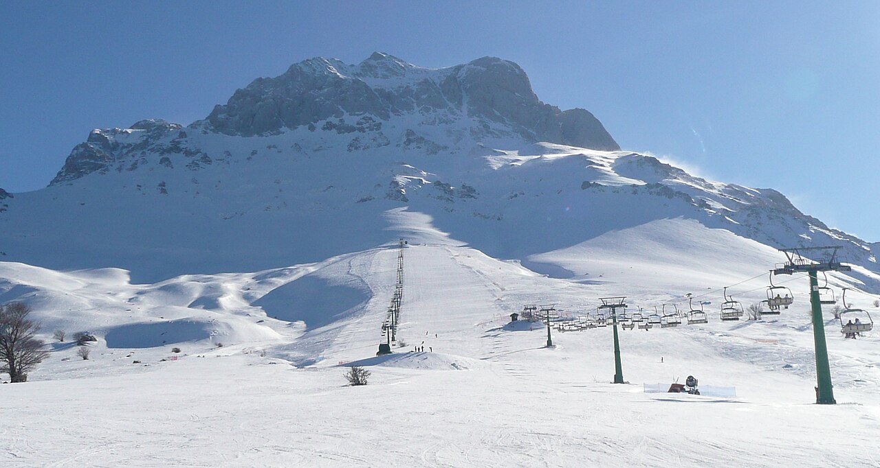
Prati di Tivo is a downhill ski area in Teramo, Italy. Mapped terrain includes easy, intermediate routes. Its mapped lift network extends from approximately 1399 to 2002 metres above sea level.
Data: OpenSkiData / OpenSkiMap, OpenStreetMap contributors (ODbL), Skimap.org, Who's On First, Mapterhorn.
Prati di Tivo - Base lift station
ECMWF · Model run: Next update expected:
Day Time (UTC) Temp. (°C) Humidity (%) Wind (km/h) Wind (knots) Wind (Bft) Direction Precip. (mm) Snow (cm) Pressure (hPa) Freezing (m) Conditions | Thursday, 05/11 06:00 3.2 90 7 4 2B E — — 1027 2590 Overcast 92% cloud 09:00 4.3 90 8 4 2B E 0.01 0 1027 2730 Cloudy 60% cloud 12:00 6 82 5 3 1B E 0.03 0 1026 2909 Overcast 81% cloud 15:00 5.4 90 4 2 1B E 0.03 0 1025 3000 Cloudy 62% cloud 18:00 4.5 92 3 2 1B E 0.01 0 1026 3098 Overcast 93% cloud 21:00 4.7 77 3 2 1B E 0.03 0 1026 3130 Overcast 89% cloud Friday, 06/11 00:00 5.3 64 3 2 1B S 0 0 1024 3079 Cloudy 73% cloud 03:00 5.2 65 2 1 1B SE 0 0 1023 3082 Overcast 80% cloud 06:00 5.2 60 3 2 1B S 0 0 1023 2961 Overcast 86% cloud 09:00 7.5 63 4 2 1B S 0 0 1022 3065 Overcast 93% cloud 12:00 7 82 3 2 1B S 0.47 0 1021 2955 Overcast 100% cloud 15:00 6.7 92 9 5 2B SE 4.3 0 1020 2958 Overcast 100% cloud 18:00 6.3 91 6 3 1B S 1.1 0 1021 2830 Overcast 100% cloud 21:00 6.6 96 7 4 2B SW 0.11 0 1020 2789 Cloudy 70% cloud Saturday, 07/11 00:00 6.1 97 6 3 2B SW 0 0 1020 2653 Cloudy 53% cloud 03:00 6 95 6 3 2B SW 0 0 1020 2591 Overcast 89% cloud 06:00 5.6 94 6 3 1B SW 0 0 1020 2484 Overcast 91% cloud 09:00 6.6 89 4 2 1B W 0.09 0 1021 2469 Partly cloudy 31% cloud 12:00 7.3 73 2 1 1B W 0.86 0 1020 2449 Cloudy 54% cloud 15:00 6.4 85 3 2 1B N 0.84 0 1021 2419 Cloudy 53% cloud 18:00 4.9 96 3 2 1B NE 0.49 0 1023 2342 Overcast 89% cloud 21:00 4.5 94 5 3 1B NE 0.00 0 1024 2297 Overcast 92% cloud Sunday, 08/11 00:00 4.2 98 5 3 1B NE 0.09 0 1025 2250 Overcast 100% cloud 03:00 4 99 4 2 1B NE 0.26 0 1024 2210 Overcast 100% cloud 06:00 3.6 96 2 1 1B E 0.41 0 1025 2207 Overcast 99% cloud 09:00 4.3 87 3 1 1B SE 0.05 0 1026 2259 Cloudy 65% cloud 12:00 6.3 66 6 3 2B SW 0.08 0 1024 2495 Cloudy 53% cloud 15:00 6 68 7 4 2B SW 0.17 0 1024 2464 Partly cloudy 39% cloud 18:00 4.6 77 5 3 1B SW 0.08 0 1025 2553 Partly cloudy 27% cloud 21:00 4.6 82 6 3 2B SW 0 0 1026 2542 Cloudy 76% cloud Monday, 09/11 00:00 4.2 86 7 4 2B W 0 0 1026 2514 Overcast 99% cloud 03:00 3.9 84 5 3 1B W 0 0 1025 2546 Overcast 96% cloud 06:00 4.2 75 5 2 1B SW 0 0 1025 2589 Overcast 96% cloud 09:00 5.9 70 5 3 1B SW 0 0 1026 2664 Overcast 98% cloud 12:00 7.2 64 9 5 2B SW 0 0 1024 2862 Overcast 99% cloud 15:00 6.7 70 10 5 2B SW 0 0 1023 3110 Overcast 88% cloud 18:00 5.4 79 9 5 2B SW 0 0 1024 3113 Partly cloudy 29% cloud 21:00 5.7 87 10 6 2B SW 0 0 1023 3078 Overcast 82% cloud Tuesday, 10/11 00:00 6 89 11 6 2B SW 0.00 0 1022 3109 Overcast 99% cloud 03:00 6.3 88 11 6 2B SW 0 0 1021 2995 Overcast 100% cloud 06:00 6.9 82 10 5 2B SW 0 0 1020 2990 Overcast 99% cloud 09:00 8.3 89 11 6 2B SW 0 0 1019 3099 Overcast 99% cloud 12:00 9.5 88 13 7 3B SW 0.24 0 1017 3087 Overcast 100% cloud 15:00 9.5 92 14 8 3B SW 0.19 0 1016 3081 Overcast 96% cloud 18:00 9 92 13 7 3B SW 0.00 0 1016 3082 Overcast 95% cloud 21:00 9.2 90 11 6 2B SW 0.00 0 1015 3080 Overcast 99% cloud Wednesday, 11/11 00:00 9.2 86 9 5 2B SW 2.1 0 1015 3045 Overcast 100% cloud 03:00 8.8 91 6 3 2B W 3.6 0 1014 3004 Overcast 100% cloud 06:00 8.7 91 5 3 1B SW 0.95 0 1014 3067 Partly cloudy 29% cloud |
|---|
Forecast notes
Forecast table times: UTC.
Coordinates: 42.4995953°N, 13.5564087°E · Requested elevation: 1446 m. Model terrain: 1233 m. Terrain and 1000/925/850/700 hPa profiles are used for height estimates.
These are altitude estimates, not a simulation of local mountain terrain. Precipitation, cloud and sea-level pressure use horizontal interpolation only.
Precipitation includes rain and snow water equivalent: preceding 3 hours through day 6, then 6 hours (see cell tooltip). Snow (cm) estimates fresh snowfall from precipitation and temperature using the GFS conversion; it is not snow depth on the ground. Freezing (m) uses additional 600/500 hPa temperatures when available and estimates the lowest resolved 0°C crossing above sea level. When all sampled levels are warm, the upper profile limit is shown (see tooltip). < marks an entirely cold sampled profile and its lower height limit. No extrapolation is used.
Source: ECMWF · CC BY 4.0 · Processed by Snow Report.
Prati di Tivo - Top lift station
ECMWF · Model run: Next update expected:
Day Time (UTC) Temp. (°C) Humidity (%) Wind (km/h) Wind (knots) Wind (Bft) Direction Precip. (mm) Snow (cm) Pressure (hPa) Freezing (m) Conditions | Thursday, 05/11 06:00 1.5 75 5 3 1B E — — 1027 2593 Overcast 92% cloud 09:00 1.8 78 7 4 2B E 0.02 0 1027 2732 Cloudy 62% cloud 12:00 3.1 72 4 2 1B E 0.03 0 1026 2906 Overcast 81% cloud 15:00 3.1 75 3 2 1B E 0.03 0 1025 2997 Cloudy 62% cloud 18:00 3.2 72 4 2 1B E 0.02 0 1026 3097 Overcast 93% cloud 21:00 3.5 58 4 2 1B SE 0.03 0 1026 3130 Overcast 88% cloud Friday, 06/11 00:00 4.2 48 4 2 1B S 0 0 1025 3077 Cloudy 73% cloud 03:00 4.4 54 2 1 1B S 0 0 1023 3083 Overcast 80% cloud 06:00 4.2 55 5 3 1B S 0 0 1023 2964 Overcast 84% cloud 09:00 4.8 62 8 4 2B S 0 0 1022 3068 Overcast 92% cloud 12:00 4.3 85 11 6 2B S 0.47 0 1021 2956 Overcast 100% cloud 15:00 4.3 91 14 8 3B S 4.2 0 1020 2958 Overcast 100% cloud 18:00 3.9 92 13 7 3B SW 1.1 0 1021 2834 Overcast 100% cloud 21:00 4 86 13 7 3B SW 0.14 0 1020 2792 Cloudy 73% cloud Saturday, 07/11 00:00 3.4 83 12 6 2B SW 0 0 1020 2655 Cloudy 56% cloud 03:00 3.3 82 9 5 2B W 0 0 1020 2594 Overcast 87% cloud 06:00 2.9 86 7 4 2B W 0 0 1020 2487 Overcast 90% cloud 09:00 2.9 82 7 4 2B SW 0.09 0 1021 2472 Partly cloudy 31% cloud 12:00 3.1 75 6 4 2B W 0.88 0 1020 2451 Cloudy 55% cloud 15:00 2.7 79 4 2 1B W 0.96 0 1021 2419 Cloudy 54% cloud 18:00 1.9 81 0 0 0B N 0.53 0 1023 2344 Overcast 86% cloud 21:00 1.6 83 2 1 1B N 0.00 0 1024 2300 Overcast 91% cloud Sunday, 08/11 00:00 1.3 87 2 1 1B NE 0.08 0 1025 2252 Overcast 100% cloud 03:00 1.1 84 2 1 1B W 0.27 0.1 1024 2215 Overcast 100% cloud 06:00 1 79 4 2 1B SW 0.47 0.1 1025 2212 Overcast 99% cloud 09:00 1.1 73 8 4 2B SW 0.06 0 1026 2262 Cloudy 68% cloud 12:00 2.6 60 15 8 3B SW 0.10 0 1024 2494 Cloudy 56% cloud 15:00 2.6 62 16 9 3B W 0.19 0 1024 2467 Partly cloudy 43% cloud 18:00 2.4 63 14 8 3B W 0.10 0 1025 2554 Partly cloudy 32% cloud 21:00 2.4 68 14 7 3B W 0 0 1026 2544 Cloudy 77% cloud Monday, 09/11 00:00 2.3 71 14 8 3B W 0 0 1026 2517 Overcast 99% cloud 03:00 2.3 65 14 7 3B W 0 0 1025 2549 Overcast 96% cloud 06:00 2.6 58 12 7 2B W 0 0 1025 2591 Overcast 96% cloud 09:00 2.9 62 12 7 3B W 0 0 1026 2668 Overcast 98% cloud 12:00 3.9 62 16 9 3B W 0 0 1024 2863 Overcast 99% cloud 15:00 4.5 61 17 9 3B W 0 0 1023 3110 Overcast 85% cloud 18:00 4.1 66 17 9 3B W 0 0 1023 3113 Partly cloudy 30% cloud 21:00 4 76 18 9 3B W 0 0 1023 3078 Cloudy 77% cloud Tuesday, 10/11 00:00 4.5 77 17 9 3B W 0.00 0 1022 3109 Overcast 99% cloud 03:00 4.5 77 20 11 3B W 0 0 1021 2996 Overcast 100% cloud 06:00 5.1 75 19 10 3B W 0 0 1020 2992 Overcast 99% cloud 09:00 5.6 77 23 13 4B SW 0 0 1019 3100 Overcast 99% cloud 12:00 6.2 86 26 14 4B SW 0.23 0 1017 3087 Overcast 100% cloud 15:00 6.5 92 23 13 4B SW 0.18 0 1016 3081 Overcast 95% cloud 18:00 6.5 91 22 12 4B W 0.06 0 1016 3082 Overcast 95% cloud 21:00 6.6 91 20 11 4B W 0.01 0 1015 3080 Overcast 99% cloud Wednesday, 11/11 00:00 6.2 89 18 10 3B W 2.0 0 1015 3048 Overcast 100% cloud 03:00 5.8 94 14 8 3B W 3.5 0 1014 3007 Overcast 100% cloud 06:00 6 91 11 6 2B W 0.95 0 1014 3067 Partly cloudy 30% cloud |
|---|
Forecast notes
Forecast table times: UTC.
Coordinates: 42.4873461°N, 13.5681103°E · Requested elevation: 2002 m. Model terrain: 1204 m. Terrain and 1000/925/850/700 hPa profiles are used for height estimates.
These are altitude estimates, not a simulation of local mountain terrain. Precipitation, cloud and sea-level pressure use horizontal interpolation only.
Precipitation includes rain and snow water equivalent: preceding 3 hours through day 6, then 6 hours (see cell tooltip). Snow (cm) estimates fresh snowfall from precipitation and temperature using the GFS conversion; it is not snow depth on the ground. Freezing (m) uses additional 600/500 hPa temperatures when available and estimates the lowest resolved 0°C crossing above sea level. When all sampled levels are warm, the upper profile limit is shown (see tooltip). < marks an entirely cold sampled profile and its lower height limit. No extrapolation is used.