Arabba · Porta Vescovo · Panorama

Provider panorama/video player. Capture time is shown by the camera.
Open camera page ↗
Each colour starts at the value shown. Wind colours match across all three units. Dry cells stay neutral. Colours describe the displayed values, not official weather warnings.
ECMWF · Model run: Next update expected:
Day Time (UTC) Temp. (°C) Humidity (%) Wind (km/h) Wind (knots) Wind (Bft) Direction Precip. (mm) Snow (cm) Pressure (hPa) Freezing (m) Conditions | Thursday, 05/11 06:00 -0.5 76 1 1 1B N — — 1027 < 1996 Clear 5% cloud  09:00 5.6 54 3 2 1B SE 0 0 1027 2789 Clear 0% cloud 12:00 8.1 46 3 2 1B S 0 0 1025 2909 Clear 0% cloud 15:00 5.3 67 2 1 1B S 0 0 1024 2820 Clear 0% cloud 18:00 1.5 72 1 1 1B NW 0 0 1025 < 1996 Clear 0% cloud 21:00 1.9 68 0 0 0B N 0 0 1024 < 1996 Clear 0% cloud Friday, 06/11 00:00 2.1 63 1 1 0B N 0 0 1023 < 1996 Clear 0% cloud 03:00 2.4 56 1 0 0B N 0 0 1021 2650 Clear 0% cloud 06:00 3 52 0 0 0B NE 0 0 1020 2841 Clear 0% cloud 09:00 7.9 37 3 2 1B SE 0 0 1021 3032 Cloudy 58% cloud  12:00 8.9 36 5 2 1B SE 0 0 1020 2934 Cloudy 69% cloud 15:00 4.9 61 2 1 1B SE 0 0 1020 2598 Overcast 98% cloud  18:00 2.6 74 1 1 1B E 0 0 1022 2140 Overcast 100% cloud 21:00 2.4 84 1 1 0B NE 0.31 0 1023 2045 Overcast 100% cloud Saturday, 07/11 00:00 2.1 85 2 1 1B E 0.42 0 1023 < 1996 Overcast 99% cloud 03:00 1.9 80 2 1 1B NE 0.20 0 1023 < 1996 Overcast 100% cloud 06:00 1.7 82 2 1 1B E 0.38 0 1024 < 1996 Overcast 98% cloud 09:00 3.2 69 3 2 1B E 0.36 0 1025 2148 Overcast 100% cloud 12:00 4.4 61 3 2 1B SE 0.06 0 1023 2291 Overcast 98% cloud 15:00 3.5 61 3 2 1B SE 0.12 0 1024 2185 Overcast 98% cloud 18:00 1.4 72 1 1 1B E 0 0 1025 < 1996 Cloudy 64% cloud 21:00 0.2 72 1 1 0B N 0 0 1026 < 1996 Partly cloudy 23% cloud  Sunday, 08/11 00:00 -0 65 1 0 0B N 0 0 1025 < 1996 Clear 11% cloud 03:00 0.2 55 0 0 0B N 0 0 1024 < 1996 Clear 9% cloud 06:00 -0 51 0 0 0B N 0 0 1025 < 1996 Clear 11% cloud 09:00 3.9 46 4 2 1B S 0 0 1025 2232 Clear 12% cloud 12:00 5.4 45 6 3 2B S 0 0 1024 2325 Partly cloudy 35% cloud 15:00 2.9 62 3 2 1B S 0 0 1024 2099 Cloudy 67% cloud 18:00 -0.4 77 1 0 0B N 0 0 1026 < 1996 Clear 19% cloud 21:00 -2 85 1 1 1B NW 0 0 1026 < 1996 Partly cloudy 40% cloud Monday, 09/11 00:00 -3.4 87 3 2 1B NW 0 0 1025 < 1996 Overcast 83% cloud 03:00 -3.3 85 2 1 1B NW 0 0 1024 < 1996 Partly cloudy 23% cloud 06:00 -2.9 83 1 0 0B N 0 0 1024 < 1996 Cloudy 69% cloud 09:00 3.9 51 4 2 1B S 0 0 1024 2323 Cloudy 71% cloud 12:00 5.2 56 6 3 1B S 0 0 1021 2504 Cloudy 54% cloud 15:00 2.6 75 4 2 1B S 0 0 1021 2135 Overcast 90% cloud 18:00 -0.4 86 1 1 1B S 0 0 1022 < 1996 Cloudy 67% cloud 21:00 -0.5 86 1 1 1B SW 0 0 1022 < 1996 Cloudy 69% cloud Tuesday, 10/11 00:00 -1.3 88 2 1 1B W 0.12 0 1020 < 1996 Overcast 98% cloud 03:00 0.1 88 2 1 1B W 0 0 1018 < 1996 Overcast 98% cloud 06:00 1.1 88 2 1 1B W 0.00 0 1017 < 1996 Overcast 100% cloud 09:00 4.6 77 4 2 1B SW 0 0 1016 2766 Cloudy 76% cloud 12:00 7.2 65 5 3 1B SW 0 0 1013 2910 Overcast 98% cloud 15:00 4.1 82 1 1 1B NW 0.13 0 1014 2812 Overcast 98% cloud 18:00 2.2 84 3 2 1B NW 0.12 0 1014 2044 Partly cloudy 46% cloud 21:00 2.8 79 2 1 1B N 0 0 1014 2478 Cloudy 65% cloud Wednesday, 11/11 00:00 3.5 75 0 0 0B NE 0 0 1014 2553 Cloudy 52% cloud 03:00 4 72 0 0 0B E 0 0 1013 2665 Clear 13% cloud 06:00 3.8 73 0 0 0B SE 0 0 1014 2654 Clear 0% cloud |
|---|
Forecast table times: UTC.
Coordinates: 46.4956308°N, 11.8740293°E · Requested elevation: 1607 m. Model terrain: 1994 m. Terrain and 1000/925/850/700 hPa profiles are used for height estimates.
Outside the available profile, temperature uses an estimated 5.5°C/km height correction; wind retains the nearest available model-level value. Humidity is estimated with adjusted pressure and temperature.
These are altitude estimates, not a simulation of local mountain terrain. Precipitation, cloud and sea-level pressure use horizontal interpolation only.
Precipitation includes rain and snow water equivalent: preceding 3 hours through day 6, then 6 hours (see cell tooltip). Snow (cm) estimates fresh snowfall from precipitation and temperature using the GFS conversion; it is not snow depth on the ground. Freezing (m) uses additional 600/500 hPa temperatures when available and estimates the lowest resolved 0°C crossing above sea level. When all sampled levels are warm, the upper profile limit is shown (see tooltip). < marks an entirely cold sampled profile and its lower height limit. No extrapolation is used.
Source: ECMWF · CC BY 4.0 · Processed by Snow Report.
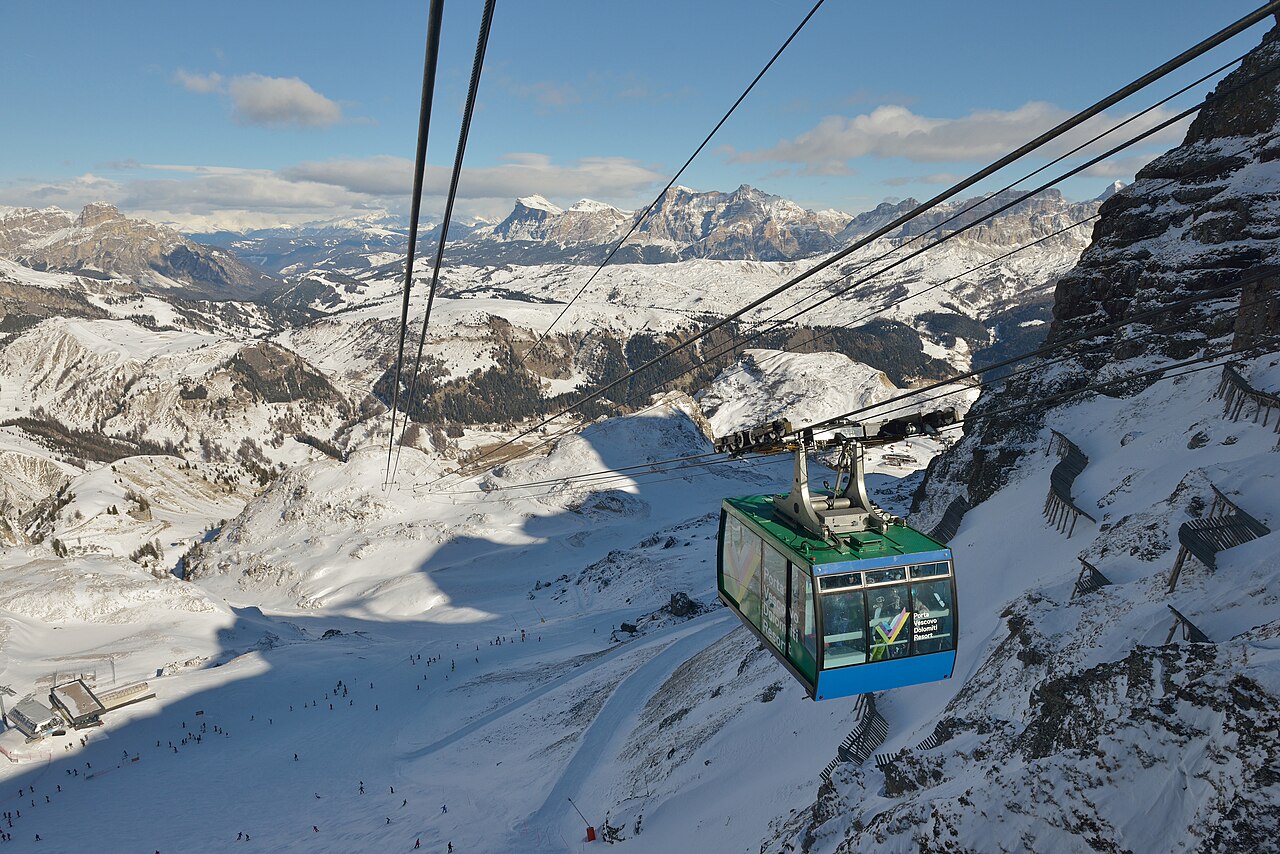
Arabba lies on the Sellaronda network, with Porta Vescovo providing a distinct high-mountain sector between the Sella landscape and the Marmolada. The Arabba–Marmolada map also shows the Pordoi, Padon and Campolongo connections. That geography makes Arabba a starting point for different kinds of day: local runs, part of the Sella circuit, or a longer excursion towards the Marmolada.
These choices are not interchangeable. Trace the actual route on the piste map and look at the difficulty markings, connections and return journey. A regional name on your ski pass is not evidence that every connecting lift is operating. The linked official map is the 2025–26 edition; consult the operator’s current information for changes before travelling.
This page’s lower reference is at 1,607 m. For Porta Vescovo or a higher excursion, select the appropriate elevation and compare the timing of wind, cloud and precipitation. If both models forecast snow but disagree on when it arrives, that may matter more for a day-long circuit than a small difference in the final total. A lower camera can show a different precipitation type from a higher one during the same episode.
Official sources: Arabba — Porta Vescovo · Arabba–Marmolada piste map. Reviewed 18 October 2026.
Provider panorama/video player. Capture time is shown by the camera.
Open camera page ↗ECMWF · Model run: Next update expected:
Day Time (UTC) Temp. (°C) Humidity (%) Wind (km/h) Wind (knots) Wind (Bft) Direction Precip. (mm) Snow (cm) Pressure (hPa) Freezing (m) Conditions | Thursday, 05/11 06:00 -0.5 76 1 1 1B N — — 1027 < 1996 Clear 5% cloud 09:00 5.5 54 3 2 1B SE 0 0 1027 2789 Clear 0% cloud 12:00 8.1 46 3 2 1B S 0 0 1025 2909 Clear 0% cloud 15:00 5.3 67 2 1 1B S 0 0 1024 2820 Clear 0% cloud 18:00 1.5 72 1 1 1B NW 0 0 1025 < 1996 Clear 0% cloud 21:00 1.9 68 0 0 0B N 0 0 1024 < 1996 Clear 0% cloud Friday, 06/11 00:00 2.1 63 1 1 0B N 0 0 1023 < 1996 Clear 0% cloud 03:00 2.4 56 1 0 0B N 0 0 1021 2650 Clear 0% cloud 06:00 3 52 0 0 0B NE 0 0 1020 2841 Clear 0% cloud 09:00 7.9 37 3 2 1B SE 0 0 1021 3032 Cloudy 57% cloud 12:00 8.9 36 5 2 1B SE 0 0 1020 2934 Cloudy 69% cloud 15:00 4.9 61 2 1 1B SE 0 0 1020 2598 Overcast 98% cloud 18:00 2.6 74 1 1 1B E 0 0 1022 2140 Overcast 100% cloud 21:00 2.3 84 1 1 0B NE 0.31 0 1023 2045 Overcast 100% cloud Saturday, 07/11 00:00 2.1 85 2 1 1B E 0.42 0 1023 < 1996 Overcast 99% cloud 03:00 1.9 80 2 1 1B NE 0.20 0 1023 < 1996 Overcast 100% cloud 06:00 1.6 82 2 1 1B E 0.38 0 1024 < 1996 Overcast 98% cloud 09:00 3.2 69 3 2 1B E 0.36 0 1025 2148 Overcast 100% cloud 12:00 4.4 61 3 2 1B SE 0.06 0 1023 2291 Overcast 98% cloud 15:00 3.5 61 3 2 1B SE 0.12 0 1024 2184 Overcast 98% cloud 18:00 1.4 72 1 1 1B E 0 0 1025 < 1996 Cloudy 64% cloud 21:00 0.2 72 1 1 0B N 0 0 1026 < 1996 Partly cloudy 23% cloud Sunday, 08/11 00:00 -0 65 1 0 0B N 0 0 1025 < 1996 Clear 11% cloud 03:00 0.1 55 0 0 0B N 0 0 1024 < 1996 Clear 9% cloud 06:00 -0 51 0 0 0B N 0 0 1025 < 1996 Clear 11% cloud 09:00 3.9 46 4 2 1B S 0 0 1025 2232 Clear 12% cloud 12:00 5.3 45 6 3 2B S 0 0 1024 2325 Partly cloudy 35% cloud 15:00 2.9 62 3 2 1B S 0 0 1024 2099 Cloudy 66% cloud 18:00 -0.4 77 1 0 0B N 0 0 1026 < 1996 Clear 19% cloud 21:00 -2 85 1 1 1B NW 0 0 1026 < 1996 Partly cloudy 40% cloud Monday, 09/11 00:00 -3.5 87 3 2 1B NW 0 0 1025 < 1996 Overcast 83% cloud 03:00 -3.3 85 2 1 1B NW 0 0 1024 < 1996 Partly cloudy 23% cloud 06:00 -2.9 83 1 0 0B N 0 0 1024 < 1996 Cloudy 69% cloud 09:00 3.9 51 4 2 1B S 0 0 1024 2323 Cloudy 70% cloud 12:00 5.2 56 6 3 1B S 0 0 1021 2504 Cloudy 54% cloud 15:00 2.5 75 4 2 1B S 0 0 1021 2135 Overcast 90% cloud 18:00 -0.4 86 1 1 1B S 0 0 1022 < 1996 Cloudy 67% cloud 21:00 -0.6 86 1 1 1B SW 0 0 1022 < 1996 Cloudy 68% cloud Tuesday, 10/11 00:00 -1.3 88 2 1 1B W 0.12 0 1020 < 1996 Overcast 98% cloud 03:00 0.1 88 2 1 1B W 0 0 1018 < 1996 Overcast 98% cloud 06:00 1.1 88 2 1 1B W 0.00 0 1017 < 1996 Overcast 100% cloud 09:00 4.6 77 4 2 1B SW 0 0 1016 2766 Cloudy 76% cloud 12:00 7.2 65 5 3 1B SW 0 0 1013 2910 Overcast 98% cloud 15:00 4.1 82 1 1 1B NW 0.13 0 1014 2812 Overcast 98% cloud 18:00 2.1 84 3 2 1B NW 0.12 0 1014 2048 Partly cloudy 46% cloud 21:00 2.8 79 2 1 1B N 0 0 1014 2479 Cloudy 65% cloud Wednesday, 11/11 00:00 3.5 75 0 0 0B NE 0 0 1014 2553 Cloudy 52% cloud 03:00 4 72 0 0 0B E 0 0 1013 2665 Clear 13% cloud 06:00 3.8 73 0 0 0B SE 0 0 1014 2654 Clear 0% cloud |
|---|
Forecast table times: UTC.
Coordinates: 46.495421°N, 11.8744431°E · Requested elevation: 1610 m. Model terrain: 1993 m. Terrain and 1000/925/850/700 hPa profiles are used for height estimates.
Outside the available profile, temperature uses an estimated 5.5°C/km height correction; wind retains the nearest available model-level value. Humidity is estimated with adjusted pressure and temperature.
These are altitude estimates, not a simulation of local mountain terrain. Precipitation, cloud and sea-level pressure use horizontal interpolation only.
Precipitation includes rain and snow water equivalent: preceding 3 hours through day 6, then 6 hours (see cell tooltip). Snow (cm) estimates fresh snowfall from precipitation and temperature using the GFS conversion; it is not snow depth on the ground. Freezing (m) uses additional 600/500 hPa temperatures when available and estimates the lowest resolved 0°C crossing above sea level. When all sampled levels are warm, the upper profile limit is shown (see tooltip). < marks an entirely cold sampled profile and its lower height limit. No extrapolation is used.
Source: ECMWF · CC BY 4.0 · Processed by Snow Report.
ECMWF · Model run: Next update expected:
Day Time (UTC) Temp. (°C) Humidity (%) Wind (km/h) Wind (knots) Wind (Bft) Direction Precip. (mm) Snow (cm) Pressure (hPa) Freezing (m) Conditions | Thursday, 05/11 06:00 -2.4 57 8 4 2B SW — — 1027 < 1965 Clear 9% cloud 09:00 1.3 46 9 5 2B S 0 0 1027 2789 Clear 0% cloud 12:00 2.7 44 7 4 2B S 0 0 1025 2905 Clear 0% cloud 15:00 1.3 56 5 3 1B S 0 0 1025 2822 Clear 0% cloud 18:00 -0.5 57 4 2 1B SW 0 0 1025 < 1965 Clear 0% cloud 21:00 -0.2 55 4 2 1B SW 0 0 1024 < 1965 Clear 0% cloud Friday, 06/11 00:00 -0.2 51 6 3 1B S 0 0 1023 < 1965 Clear 0% cloud 03:00 0 47 5 3 1B S 0 0 1022 2488 Clear 0% cloud 06:00 0.3 45 4 2 1B S 0 0 1020 2777 Clear 0% cloud 09:00 3 38 10 5 2B SE 0 0 1021 3027 Cloudy 57% cloud 12:00 3.2 38 14 7 3B S 0 0 1020 2929 Cloudy 72% cloud 15:00 0.5 55 13 7 3B SE 0 0 1020 2595 Overcast 98% cloud 18:00 -1.2 63 14 7 3B SE 0 0 1022 2151 Overcast 100% cloud 21:00 -2.1 77 16 8 3B SE 0.35 0.1 1023 2037 Overcast 100% cloud Saturday, 07/11 00:00 -2.6 87 19 10 3B SE 0.40 0.1 1023 1983 Overcast 99% cloud 03:00 -3.2 92 16 9 3B SE 0.26 0.3 1023 < 1965 Overcast 100% cloud 06:00 -3.3 94 11 6 2B SE 0.45 0.5 1024 < 1965 Overcast 99% cloud 09:00 -2.4 85 8 5 2B SE 0.34 0.1 1025 2136 Overcast 100% cloud 12:00 -1.6 78 13 7 3B SE 0.07 0 1024 2280 Overcast 98% cloud 15:00 -2.2 75 12 7 3B SE 0.12 0 1024 2176 Overcast 98% cloud 18:00 -3.2 85 10 5 2B SE 0 0 1025 < 1965 Cloudy 68% cloud 21:00 -3.9 76 8 4 2B SE 0 0 1026 < 1965 Partly cloudy 23% cloud Sunday, 08/11 00:00 -4.1 75 7 4 2B SE 0 0 1025 < 1965 Clear 11% cloud 03:00 -4 67 6 3 2B SE 0 0 1025 < 1965 Clear 9% cloud 06:00 -4.3 67 3 2 1B S 0 0 1025 < 1965 Clear 11% cloud 09:00 -2 59 5 3 1B S 0 0 1025 2224 Clear 12% cloud 12:00 -1.7 63 6 3 2B SW 0 0 1024 2316 Partly cloudy 37% cloud 15:00 -3 78 4 2 1B W 0 0 1024 2088 Cloudy 63% cloud 18:00 -4.6 83 6 3 1B W 0 0 1026 < 1965 Clear 18% cloud 21:00 -5.1 82 6 3 2B NW 0 0 1026 < 1965 Partly cloudy 40% cloud Monday, 09/11 00:00 -5.6 74 7 4 2B NW 0 0 1026 < 1965 Overcast 82% cloud 03:00 -5.4 72 7 4 2B W 0 0 1024 < 1965 Partly cloudy 28% cloud 06:00 -4.9 70 8 4 2B W 0 0 1024 < 1965 Cloudy 71% cloud 09:00 -0.9 53 9 5 2B SW 0 0 1024 2311 Cloudy 71% cloud 12:00 0.1 57 14 8 3B SW 0 0 1022 2501 Cloudy 56% cloud 15:00 -1 71 16 9 3B SW 0 0 1021 2147 Overcast 88% cloud 18:00 -2.5 79 17 9 3B SW 0 0 1022 < 1965 Cloudy 67% cloud 21:00 -2.2 82 19 10 3B W 0 0 1022 < 1965 Cloudy 68% cloud Tuesday, 10/11 00:00 -2.4 86 20 11 3B W 0.11 0 1020 < 1965 Overcast 97% cloud 03:00 -1.6 87 19 10 3B W 0 0 1018 < 1965 Overcast 99% cloud 06:00 -1 87 17 9 3B W 0.01 0 1017 < 1965 Overcast 100% cloud 09:00 0.9 82 16 9 3B W 0 0 1016 2775 Cloudy 78% cloud 12:00 2.3 76 16 9 3B W 0 0 1014 2914 Overcast 99% cloud 15:00 0.8 88 14 8 3B W 0.17 0 1014 2824 Overcast 98% cloud 18:00 -0.1 88 13 7 3B NW 0.12 0 1014 2221 Partly cloudy 47% cloud 21:00 -0 85 10 6 2B NW 0 0 1014 2445 Cloudy 64% cloud Wednesday, 11/11 00:00 0.1 82 7 4 2B NW 0 0 1014 2526 Cloudy 54% cloud 03:00 0.4 79 5 2 1B W 0 0 1013 2649 Clear 16% cloud 06:00 0.3 78 6 3 2B W 0 0 1014 2636 Clear 0% cloud |
|---|
Forecast table times: UTC.
Coordinates: 46.4731123°N, 11.8671064°E · Requested elevation: 2485 m. Model terrain: 1962 m. Terrain and 1000/925/850/700 hPa profiles are used for height estimates.
These are altitude estimates, not a simulation of local mountain terrain. Precipitation, cloud and sea-level pressure use horizontal interpolation only.
Precipitation includes rain and snow water equivalent: preceding 3 hours through day 6, then 6 hours (see cell tooltip). Snow (cm) estimates fresh snowfall from precipitation and temperature using the GFS conversion; it is not snow depth on the ground. Freezing (m) uses additional 600/500 hPa temperatures when available and estimates the lowest resolved 0°C crossing above sea level. When all sampled levels are warm, the upper profile limit is shown (see tooltip). < marks an entirely cold sampled profile and its lower height limit. No extrapolation is used.