Worldwide Ski Resort Forecasts

More
Colour guide Temperature · Wind · Rain · Snow
Each colour starts at the value shown. Wind colours match across all three units. Dry cells stay neutral. Colours describe the displayed values, not official weather warnings.
Weardale Ski Club - Base lift station
ECMWF · Model run: Next update expected:
Day Local time Temp. (°C) Humidity (%) Wind (km/h) Wind (knots) Wind (Bft) Direction Precip. (mm) Snow (cm) Pressure (hPa) Freezing (m) Conditions | Thursday, 05/11 06:00 5.8 99 24 13 4B E — — 1032 2026 Overcast 87% cloud  09:00 5.9 100 26 14 4B E 0.20 0 1032 1818 Overcast 100% cloud 12:00 6.8 95 28 15 4B E 0.49 0 1031 1548 Overcast 99% cloud 15:00 6.2 95 23 13 4B E 0.37 0 1030 1975 Overcast 89% cloud 18:00 5.6 96 22 12 4B E 0.24 0 1029 2171 Overcast 93% cloud 21:00 5.6 96 23 12 4B E 0.09 0 1030 2140 Overcast 95% cloud Friday, 06/11 00:00 5.6 98 20 11 4B E 0.26 0 1029 2183 Overcast 99% cloud 03:00 5.4 97 18 10 3B E 0 0 1028 2023 Overcast 99% cloud 06:00 5.3 97 17 9 3B E 0.14 0 1027 2050 Overcast 97% cloud 09:00 5.9 96 19 10 3B E 0.23 0 1027 1836 Overcast 100% cloud 12:00 7.4 86 18 10 3B E 0.28 0 1027 1803 Overcast 100% cloud 15:00 6.7 87 16 9 3B E 0.17 0 1026 1876 Overcast 100% cloud 18:00 5.7 97 13 7 3B NE 0 0 1026 1981 Overcast 100% cloud 21:00 5.6 97 11 6 2B NE 0.10 0 1026 1698 Overcast 100% cloud Saturday, 07/11 00:00 5.4 98 7 4 2B NE 0.11 0 1025 1435 Overcast 100% cloud 03:00 5.4 97 7 4 2B NE 0.05 0 1024 1513 Overcast 100% cloud 06:00 5.3 97 6 3 2B NE 0.20 0 1024 1451 Overcast 100% cloud 09:00 5.6 97 6 3 2B NE 0.24 0 1024 1391 Overcast 100% cloud 12:00 6.2 96 6 3 2B NE 0.46 0 1023 1373 Overcast 100% cloud 15:00 6.1 95 3 2 1B NE 0.65 0 1022 1387 Overcast 100% cloud 18:00 5.5 99 2 1 1B N 0.42 0 1022 1344 Overcast 100% cloud 21:00 5.4 98 2 1 1B N 0.14 0 1022 1348 Overcast 100% cloud Sunday, 08/11 00:00 5.3 98 3 2 1B NW 0.21 0 1021 1328 Overcast 100% cloud 03:00 5.1 99 3 2 1B NW 0.10 0 1020 1316 Overcast 100% cloud 06:00 4.9 99 4 2 1B NW 0.17 0 1020 1325 Overcast 100% cloud 09:00 5.3 96 4 2 1B NW 0.09 0 1020 1337 Overcast 99% cloud 12:00 6.3 88 3 2 1B N 0.02 0 1019 1368 Overcast 85% cloud 15:00 5.9 88 3 2 1B NW 0.21 0 1019 1341 Overcast 97% cloud 18:00 4.5 98 2 1 1B N 0.37 0 1019 1321 Cloudy 79% cloud  21:00 3.8 98 1 1 1B E 0 0 1020 1290 Overcast 83% cloud Monday, 09/11 00:00 2.2 98 1 1 1B NE 0 0 1019 1228 Cloudy 69% cloud 03:00 2.4 95 3 1 1B N 0 0 1019 1160 Overcast 81% cloud 06:00 1.8 94 4 2 1B N 0 0 1019 1143 Partly cloudy 29% cloud  09:00 3 93 4 2 1B N 0 0 1020 1092 Cloudy 78% cloud 12:00 4.8 91 8 5 2B NE 0 0 1020 1111 Cloudy 59% cloud 15:00 4.8 88 11 6 2B NE 0.08 0 1018 1284 Partly cloudy 50% cloud 18:00 3.3 96 10 5 2B NE 0 0 1018 2048 Cloudy 65% cloud 21:00 3.1 90 10 5 2B E 0 0 1018 2116 Partly cloudy 47% cloud Tuesday, 10/11 00:00 2.9 90 10 6 2B E 0.02 0 1017 2108 Partly cloudy 42% cloud 03:00 3.2 97 12 6 2B E 0 0 1016 2278 Overcast 86% cloud 06:00 3.1 98 12 6 2B SE 0 0 1016 2285 Cloudy 79% cloud 09:00 3.8 97 15 8 3B SE 0 0 1015 2363 Overcast 89% cloud 12:00 5.5 85 22 12 4B SE 0 0 1014 2438 Overcast 90% cloud 15:00 5.3 85 17 9 3B SE 0 0 1013 2480 Clear 3% cloud  18:00 3.1 97 17 9 3B SE 0 0 1012 2626 Partly cloudy 32% cloud 21:00 2.7 96 18 10 3B SE 0 0 1011 2579 Overcast 82% cloud Wednesday, 11/11 00:00 3.6 96 21 11 4B SE 0 0 1010 2460 Overcast 100% cloud 03:00 3.8 99 20 11 4B SE 0.06 0 1007 2444 Overcast 100% cloud 06:00 4.2 98 16 8 3B SE 0.24 0 1005 2464 Overcast 100% cloud |
|---|
Forecast notes
Forecast table times: Europe/London.
Coordinates: 54.7011744°N, -2.1742652°E · Requested elevation: 492 m. Model terrain: 470 m. Terrain and 1000/925/850/700 hPa profiles are used for height estimates.
These are altitude estimates, not a simulation of local mountain terrain. Precipitation, cloud and sea-level pressure use horizontal interpolation only.
Precipitation includes rain and snow water equivalent: preceding 3 hours through day 6, then 6 hours (see cell tooltip). Snow (cm) estimates fresh snowfall from precipitation and temperature using the GFS conversion; it is not snow depth on the ground. Freezing (m) uses additional 600/500 hPa temperatures when available and estimates the lowest resolved 0°C crossing above sea level. When all sampled levels are warm, the upper profile limit is shown (see tooltip). < marks an entirely cold sampled profile and its lower height limit. No extrapolation is used.
Source: ECMWF · CC BY 4.0 · Processed by Snow Report.
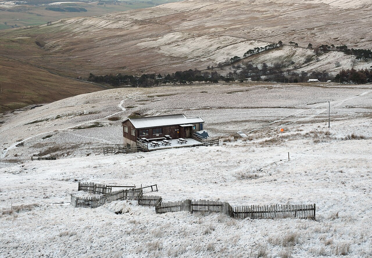
Weardale Ski Club is a mapped downhill ski area in GB. Forecasts cover three real lift-station locations from approximately 492 to 658 metres. Elevations are terrain-model estimates.
Data: OpenSkiData / OpenSkiMap, OpenStreetMap contributors (ODbL), Skimap.org, Who's On First, Mapterhorn.
Weardale Ski Club - Middle lift station
ECMWF · Model run: Next update expected:
Day Local time Temp. (°C) Humidity (%) Wind (km/h) Wind (knots) Wind (Bft) Direction Precip. (mm) Snow (cm) Pressure (hPa) Freezing (m) Conditions | Thursday, 05/11 06:00 5.2 98 30 16 5B E — — 1032 2030 Overcast 87% cloud 09:00 5.3 99 32 17 5B E 0.20 0 1032 1827 Overcast 100% cloud 12:00 6.1 96 34 18 5B E 0.48 0 1031 1553 Overcast 99% cloud 15:00 5.5 96 29 16 5B E 0.36 0 1030 1986 Overcast 89% cloud 18:00 5 96 29 16 5B E 0.24 0 1029 2176 Overcast 93% cloud 21:00 5.1 97 30 16 5B E 0.09 0 1029 2142 Overcast 95% cloud Friday, 06/11 00:00 5 98 26 14 4B E 0.26 0 1029 2185 Overcast 99% cloud 03:00 4.9 96 24 13 4B E 0 0 1028 2025 Overcast 99% cloud 06:00 4.8 98 23 13 4B E 0.13 0 1027 2054 Overcast 97% cloud 09:00 5.3 97 24 13 4B E 0.23 0 1027 1841 Overcast 100% cloud 12:00 6.5 88 21 11 4B E 0.28 0 1027 1807 Overcast 100% cloud 15:00 5.9 89 19 10 3B E 0.17 0 1026 1876 Overcast 100% cloud 18:00 5.2 97 17 9 3B E 0 0 1026 1982 Overcast 100% cloud 21:00 5 98 15 8 3B E 0.10 0 1026 1698 Overcast 100% cloud Saturday, 07/11 00:00 4.9 98 11 6 2B NE 0.10 0 1025 1436 Overcast 100% cloud 03:00 4.9 97 10 6 2B NE 0.05 0 1024 1513 Overcast 100% cloud 06:00 4.8 98 10 5 2B NE 0.21 0 1024 1451 Overcast 100% cloud 09:00 5 97 9 5 2B NE 0.24 0 1024 1391 Overcast 100% cloud 12:00 5.5 95 7 4 2B E 0.45 0 1023 1373 Overcast 100% cloud 15:00 5.4 95 4 2 1B NE 0.65 0 1022 1388 Overcast 100% cloud 18:00 4.9 99 3 2 1B NE 0.42 0 1022 1344 Overcast 100% cloud 21:00 4.9 99 3 1 1B N 0.13 0 1022 1348 Overcast 100% cloud Sunday, 08/11 00:00 4.7 98 3 2 1B NW 0.21 0 1021 1328 Overcast 100% cloud 03:00 4.5 99 4 2 1B N 0.10 0 1020 1317 Overcast 100% cloud 06:00 4.4 98 6 3 1B N 0.17 0 1020 1325 Overcast 100% cloud 09:00 4.7 95 4 2 1B N 0.09 0 1020 1337 Overcast 99% cloud 12:00 5.4 90 3 2 1B N 0.02 0 1019 1367 Overcast 85% cloud 15:00 5.2 89 3 2 1B NW 0.21 0 1019 1341 Overcast 97% cloud 18:00 4.1 97 4 2 1B NE 0.36 0 1019 1322 Cloudy 78% cloud 21:00 3.6 96 4 2 1B E 0 0 1020 1290 Overcast 83% cloud Monday, 09/11 00:00 2.3 95 3 2 1B NE 0 0 1019 1229 Cloudy 70% cloud 03:00 2.4 91 6 3 1B NE 0 0 1019 1161 Overcast 82% cloud 06:00 2 90 7 4 2B NE 0 0 1019 1144 Partly cloudy 30% cloud 09:00 2.6 92 7 4 2B NE 0 0 1020 1093 Cloudy 78% cloud 12:00 4 92 11 6 2B NE 0 0 1020 1113 Cloudy 59% cloud 15:00 4 88 13 7 3B NE 0.08 0 1018 1288 Partly cloudy 49% cloud 18:00 2.9 96 15 8 3B NE 0 0 1018 2051 Cloudy 65% cloud 21:00 2.8 89 16 8 3B E 0 0 1018 2118 Partly cloudy 46% cloud Tuesday, 10/11 00:00 2.7 92 16 9 3B E 0.02 0 1017 2111 Partly cloudy 41% cloud 03:00 3 98 18 10 3B E 0 0 1016 2280 Overcast 85% cloud 06:00 2.9 97 18 10 3B SE 0 0 1016 2286 Cloudy 80% cloud 09:00 3.3 98 23 12 4B SE 0 0 1015 2364 Overcast 89% cloud 12:00 4.6 88 27 15 4B SE 0 0 1014 2440 Overcast 90% cloud 15:00 4.6 87 24 13 4B SE 0 0 1013 2481 Clear 3% cloud 18:00 3.2 95 25 13 4B SE 0 0 1012 2627 Partly cloudy 32% cloud 21:00 3.3 91 28 15 4B SE 0 0 1011 2579 Overcast 82% cloud Wednesday, 11/11 00:00 4.1 84 31 17 5B SE 0 0 1010 2459 Overcast 100% cloud 03:00 4 95 30 16 5B SE 0.06 0 1007 2445 Overcast 100% cloud 06:00 4.3 97 24 13 4B SE 0.24 0 1005 2465 Overcast 100% cloud |
|---|
Forecast notes
Forecast table times: Europe/London.
Coordinates: 54.6982195°N, -2.1777733°E · Requested elevation: 580 m. Model terrain: 471 m. Terrain and 1000/925/850/700 hPa profiles are used for height estimates.
These are altitude estimates, not a simulation of local mountain terrain. Precipitation, cloud and sea-level pressure use horizontal interpolation only.
Precipitation includes rain and snow water equivalent: preceding 3 hours through day 6, then 6 hours (see cell tooltip). Snow (cm) estimates fresh snowfall from precipitation and temperature using the GFS conversion; it is not snow depth on the ground. Freezing (m) uses additional 600/500 hPa temperatures when available and estimates the lowest resolved 0°C crossing above sea level. When all sampled levels are warm, the upper profile limit is shown (see tooltip). < marks an entirely cold sampled profile and its lower height limit. No extrapolation is used.
Source: ECMWF · CC BY 4.0 · Processed by Snow Report.
Weardale Ski Club - Top lift station
ECMWF · Model run: Next update expected:
Day Local time Temp. (°C) Humidity (%) Wind (km/h) Wind (knots) Wind (Bft) Direction Precip. (mm) Snow (cm) Pressure (hPa) Freezing (m) Conditions | Thursday, 05/11 06:00 4.7 98 35 19 5B E — — 1032 2034 Overcast 86% cloud 09:00 4.8 99 37 20 5B E 0.20 0 1032 1834 Overcast 100% cloud 12:00 5.4 97 39 21 5B E 0.48 0 1031 1557 Overcast 99% cloud 15:00 4.9 96 35 19 5B E 0.36 0 1030 1994 Overcast 88% cloud 18:00 4.5 96 36 19 5B E 0.23 0 1029 2181 Overcast 93% cloud 21:00 4.6 97 36 19 5B E 0.09 0 1029 2144 Overcast 95% cloud Friday, 06/11 00:00 4.4 98 31 17 5B E 0.25 0 1028 2187 Overcast 99% cloud 03:00 4.4 96 29 16 5B E 0 0 1028 2027 Overcast 98% cloud 06:00 4.4 98 29 15 4B E 0.13 0 1027 2057 Overcast 97% cloud 09:00 4.8 97 29 16 5B E 0.22 0 1027 1847 Overcast 100% cloud 12:00 5.8 90 23 13 4B E 0.28 0 1027 1811 Overcast 100% cloud 15:00 5.2 91 22 12 4B E 0.17 0 1026 1877 Overcast 100% cloud 18:00 4.6 98 21 12 4B E 0 0 1026 1983 Overcast 100% cloud 21:00 4.5 98 18 10 3B E 0.10 0 1026 1698 Overcast 100% cloud Saturday, 07/11 00:00 4.4 98 14 8 3B E 0.10 0 1025 1436 Overcast 100% cloud 03:00 4.4 98 13 7 3B NE 0.05 0 1024 1512 Overcast 100% cloud 06:00 4.3 98 13 7 3B NE 0.21 0 1024 1452 Overcast 100% cloud 09:00 4.5 98 12 7 2B E 0.24 0 1024 1391 Overcast 100% cloud 12:00 4.9 95 9 5 2B E 0.45 0 1023 1373 Overcast 100% cloud 15:00 4.8 95 5 3 1B E 0.64 0 1022 1388 Overcast 100% cloud 18:00 4.4 98 4 2 1B NE 0.41 0 1022 1345 Overcast 100% cloud 21:00 4.3 99 3 2 1B NE 0.13 0 1022 1348 Overcast 100% cloud Sunday, 08/11 00:00 4.2 99 4 2 1B N 0.21 0 1021 1328 Overcast 100% cloud 03:00 4 99 4 2 1B N 0.10 0 1020 1317 Overcast 100% cloud 06:00 4 98 7 4 2B N 0.17 0 1020 1325 Overcast 100% cloud 09:00 4.2 94 5 3 1B N 0.10 0 1020 1337 Overcast 99% cloud 12:00 4.7 91 3 2 1B NE 0.02 0 1019 1366 Overcast 85% cloud 15:00 4.6 90 4 2 1B NW 0.20 0 1019 1341 Overcast 97% cloud 18:00 3.7 97 5 3 1B NE 0.35 0 1019 1322 Cloudy 78% cloud 21:00 3.4 93 6 3 2B E 0 0 1020 1290 Overcast 83% cloud Monday, 09/11 00:00 2.4 92 5 3 1B NE 0 0 1019 1229 Cloudy 70% cloud 03:00 2.5 88 8 4 2B NE 0 0 1019 1161 Overcast 82% cloud 06:00 2.1 86 10 6 2B NE 0 0 1019 1146 Partly cloudy 31% cloud 09:00 2.3 91 9 5 2B NE 0 0 1020 1094 Cloudy 78% cloud 12:00 3.4 92 13 7 3B NE 0 0 1020 1114 Cloudy 59% cloud 15:00 3.3 89 16 9 3B NE 0.08 0 1018 1291 Partly cloudy 49% cloud 18:00 2.6 96 21 11 4B NE 0 0 1018 2053 Cloudy 65% cloud 21:00 2.5 87 21 11 4B E 0 0 1018 2119 Partly cloudy 46% cloud Tuesday, 10/11 00:00 2.6 93 21 11 4B E 0.02 0 1017 2114 Partly cloudy 41% cloud 03:00 2.8 98 23 12 4B E 0 0 1016 2282 Overcast 84% cloud 06:00 2.7 97 24 13 4B SE 0 0 1016 2287 Cloudy 80% cloud 09:00 2.9 98 29 16 5B SE 0 0 1015 2366 Overcast 90% cloud 12:00 3.7 90 32 17 5B SE 0 0 1014 2443 Overcast 90% cloud 15:00 3.9 87 31 17 5B SE 0 0 1013 2482 Clear 3% cloud 18:00 3.3 94 32 17 5B SE 0 0 1012 2628 Partly cloudy 32% cloud 21:00 3.8 87 36 19 5B SE 0 0 1011 2579 Overcast 83% cloud Wednesday, 11/11 00:00 4.6 75 40 22 6B SE 0 0 1010 2458 Overcast 100% cloud 03:00 4.2 92 39 21 5B SE 0.05 0 1007 2445 Overcast 100% cloud 06:00 4.4 95 31 17 5B SE 0.24 0 1005 2466 Overcast 100% cloud |
|---|
Forecast notes
Forecast table times: Europe/London.
Coordinates: 54.6951269°N, -2.1805345°E · Requested elevation: 658 m. Model terrain: 471 m. Terrain and 1000/925/850/700 hPa profiles are used for height estimates.
These are altitude estimates, not a simulation of local mountain terrain. Precipitation, cloud and sea-level pressure use horizontal interpolation only.
Precipitation includes rain and snow water equivalent: preceding 3 hours through day 6, then 6 hours (see cell tooltip). Snow (cm) estimates fresh snowfall from precipitation and temperature using the GFS conversion; it is not snow depth on the ground. Freezing (m) uses additional 600/500 hPa temperatures when available and estimates the lowest resolved 0°C crossing above sea level. When all sampled levels are warm, the upper profile limit is shown (see tooltip). < marks an entirely cold sampled profile and its lower height limit. No extrapolation is used.