Worldwide Ski Resort Forecasts

More
Colour guide Temperature · Wind · Rain · Snow
Each colour starts at the value shown. Wind colours match across all three units. Dry cells stay neutral. Colours describe the displayed values, not official weather warnings.
Preparing forecast graphs…
Times and values match the detailed forecast. Tap or point at a value for details. Scroll each chart sideways for later days. Rain / precipitation is the total water equivalent per forecast interval, including snow; snowfall is fresh snow per interval, not snow depth.
GFS and ECMWF model comparison. Each model retains its own forecast times and horizon. Precipitation and snowfall amounts cover their own forecast intervals; these can differ between models.
Forecast values and model notes
Nub's Nob - Low lift station
ECMWF · Model run: Next update expected:
Day Time (UTC) Temp. (°C) Humidity (%) Wind (km/h) Wind (knots) Wind (Bft) Direction Precip. (mm) Snow (cm) Pressure (hPa) Freezing (m) Conditions | Thursday, 05/11 06:00 11.5 90 21 11 4B SW — — 1001 2930 Overcast 100% cloud  09:00 10.7 93 24 13 4B SW 0.80 0 1001 2296 Overcast 100% cloud 12:00 10.4 94 25 14 4B SW 0.46 0 1001 2270 Overcast 100% cloud 15:00 10.1 97 28 15 4B SW 1.7 0 1002 2266 Overcast 100% cloud 18:00 9.3 96 25 14 4B W 2.2 0 1003 2394 Overcast 100% cloud 21:00 7.3 88 28 15 4B NW 0.65 0 1005 2067 Overcast 100% cloud Friday, 06/11 00:00 5.1 96 30 16 5B N 1.6 0 1010 1155 Overcast 100% cloud 03:00 4.9 81 25 14 4B N 0.26 0 1013 807 Overcast 100% cloud 06:00 4.5 80 23 13 4B N 0.22 0 1014 743 Overcast 100% cloud 09:00 3.6 92 25 14 4B N 0.78 0 1015 684 Overcast 100% cloud 12:00 2.8 97 25 13 4B N 1.2 0 1017 625 Overcast 100% cloud 15:00 2.6 95 24 13 4B N 1.2 0 1019 608 Overcast 100% cloud 18:00 3.6 80 23 12 4B N 0.46 0 1019 641 Overcast 100% cloud 21:00 3.9 79 20 11 4B N 0.24 0 1019 674 Overcast 100% cloud Saturday, 07/11 00:00 4 78 18 10 3B N 0 0 1020 710 Overcast 97% cloud 03:00 4.3 72 14 7 3B N 0 0 1021 771 Overcast 100% cloud 06:00 3.5 76 11 6 2B N 0 0 1020 738 Cloudy 68% cloud  09:00 2.7 84 11 6 2B N 0 0 1020 788 Cloudy 68% cloud 12:00 2.1 88 11 6 2B N 0 0 1021 1999 Clear 3% cloud  15:00 5 70 11 6 2B NW 0 0 1021 2290 Clear 1% cloud 18:00 6.7 62 13 7 3B W 0 0 1020 2343 Clear 5% cloud 21:00 6.2 72 16 9 3B W 0 0 1019 2464 Clear 17% cloud Sunday, 08/11 00:00 4.8 85 15 8 3B SW 0 0 1018 2501 Partly cloudy 23% cloud  03:00 4.8 90 19 10 3B SW 0 0 1016 3025 Cloudy 78% cloud 06:00 5.8 90 22 12 4B SW 0 0 1013 2960 Clear 0% cloud 09:00 7.6 85 27 14 4B SW 0 0 1010 2344 Partly cloudy 37% cloud 12:00 8.1 87 26 14 4B W 0.06 0 1009 1804 Cloudy 56% cloud 15:00 9.7 75 27 14 4B W 0.02 0 1009 1586 Cloudy 73% cloud 18:00 9.7 71 30 16 5B NW 0.10 0 1009 1402 Overcast 99% cloud 21:00 9 68 28 15 4B NW 0.14 0 1011 1251 Cloudy 72% cloud Monday, 09/11 00:00 7.5 76 26 14 4B NW 0 0 1012 1241 Partly cloudy 41% cloud 03:00 6.8 78 27 14 4B NW 0.16 0 1013 1104 Overcast 92% cloud 06:00 6.8 69 25 13 4B NW 0.01 0 1014 1078 Partly cloudy 39% cloud 09:00 6.7 71 22 12 4B NW 0 0 1016 1053 Overcast 94% cloud 12:00 6.3 75 16 9 3B NW 0 0 1017 2137 Overcast 100% cloud 15:00 7.3 70 13 7 3B NW 0 0 1018 2978 Overcast 100% cloud 18:00 8.4 65 15 8 3B W 0 0 1017 2879 Overcast 100% cloud 21:00 8.2 75 17 9 3B SW 0 0 1016 3033 Overcast 86% cloud Tuesday, 10/11 00:00 7.6 76 18 10 3B SW 0.04 0 1014 2909 Cloudy 69% cloud 03:00 7.9 77 22 12 4B SW 0 0 1012 2809 Cloudy 57% cloud 06:00 9.2 85 21 11 4B W 0 0 1010 2445 Overcast 87% cloud 09:00 7.8 90 16 9 3B W 0.03 0 1009 2179 Clear 0% cloud 12:00 7.1 90 17 9 3B W 0 0 1010 1933 Clear 0% cloud 15:00 9 79 21 11 4B W 0 0 1011 1875 Clear 13% cloud 18:00 9.4 67 21 12 4B W 0 0 1012 1705 Clear 18% cloud 21:00 9.2 65 20 11 3B W 0 0 1012 1361 Partly cloudy 49% cloud Wednesday, 11/11 00:00 6.6 81 10 5 2B W 0 0 1013 1386 Partly cloudy 45% cloud 03:00 6.1 88 9 5 2B W 0 0 1012 1418 Overcast 83% cloud 06:00 5.8 81 10 5 2B NW 0 0 1012 1353 Cloudy 63% cloud |
|---|
Forecast notes
Forecast table times: UTC.
Coordinates: 45.4583397°N, -84.9080622°E · Requested elevation: 280 m. Model terrain: 245 m. Terrain and 1000/925/850/700 hPa profiles are used for height estimates.
These are altitude estimates, not a simulation of local mountain terrain. Precipitation, cloud and sea-level pressure use horizontal interpolation only.
Precipitation includes rain and snow water equivalent: preceding 3 hours through day 6, then 6 hours (see cell tooltip). Snow (cm) estimates fresh snowfall from precipitation and temperature using the GFS conversion; it is not snow depth on the ground. Freezing (m) uses additional 600/500 hPa temperatures when available and estimates the lowest resolved 0°C crossing above sea level. When all sampled levels are warm, the upper profile limit is shown (see tooltip). < marks an entirely cold sampled profile and its lower height limit. No extrapolation is used.
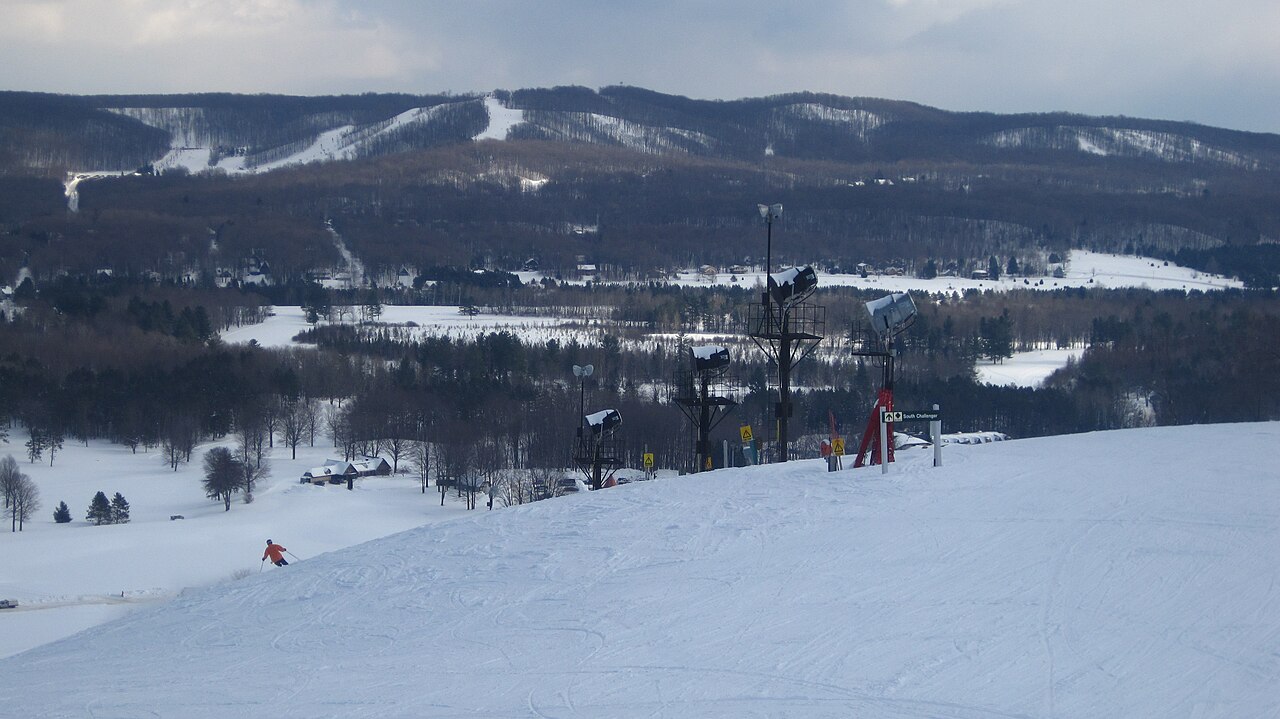
Nub's Nob is a downhill ski area in Michigan, United States. Mapped terrain includes beginner, easy, intermediate, advanced routes. Its mapped lift network extends from approximately 280 to 405 metres above sea level. Cross-country skiing is also mapped within the area.
Data: OpenSkiData / OpenSkiMap, OpenStreetMap contributors (ODbL), Skimap.org, Who's On First, Mapterhorn.
Preparing forecast graphs…
Times and values match the detailed forecast. Tap or point at a value for details. Scroll each chart sideways for later days. Rain / precipitation is the total water equivalent per forecast interval, including snow; snowfall is fresh snow per interval, not snow depth.
GFS and ECMWF model comparison. Each model retains its own forecast times and horizon. Precipitation and snowfall amounts cover their own forecast intervals; these can differ between models.
Forecast values and model notes
Nub's Nob - Base lift station
ECMWF · Model run: Next update expected:
Day Time (UTC) Temp. (°C) Humidity (%) Wind (km/h) Wind (knots) Wind (Bft) Direction Precip. (mm) Snow (cm) Pressure (hPa) Freezing (m) Conditions | Thursday, 05/11 06:00 11.5 90 22 12 4B SW — — 1001 2930 Overcast 100% cloud 09:00 10.7 94 24 13 4B SW 0.82 0 1001 2301 Overcast 100% cloud 12:00 10.3 94 26 14 4B SW 0.47 0 1001 2273 Overcast 100% cloud 15:00 10.1 97 29 15 4B SW 1.7 0 1002 2269 Overcast 100% cloud 18:00 9.2 96 25 14 4B W 2.2 0 1003 2397 Overcast 100% cloud 21:00 7.2 88 28 15 4B NW 0.63 0 1005 2074 Overcast 100% cloud Friday, 06/11 00:00 5 96 30 16 5B N 1.6 0 1010 1155 Overcast 100% cloud 03:00 4.9 82 25 14 4B N 0.26 0 1013 805 Overcast 100% cloud 06:00 4.4 80 24 13 4B N 0.23 0 1014 741 Overcast 100% cloud 09:00 3.5 92 26 14 4B N 0.80 0 1015 682 Overcast 100% cloud 12:00 2.7 97 25 14 4B N 1.2 0 1017 624 Overcast 100% cloud 15:00 2.6 95 24 13 4B N 1.2 0 1019 607 Overcast 100% cloud 18:00 3.5 81 23 12 4B N 0.47 0 1019 640 Overcast 100% cloud 21:00 3.8 79 21 11 4B N 0.25 0 1019 672 Overcast 100% cloud Saturday, 07/11 00:00 4 79 18 10 3B N 0 0 1020 709 Overcast 98% cloud 03:00 4.3 71 14 7 3B N 0 0 1021 772 Overcast 99% cloud 06:00 3.4 76 11 6 2B N 0 0 1020 736 Cloudy 69% cloud 09:00 2.6 83 11 6 2B N 0 0 1020 1853 Cloudy 68% cloud 12:00 2.1 88 11 6 2B N 0 0 1021 1999 Clear 2% cloud 15:00 4.9 70 11 6 2B NW 0 0 1021 2290 Clear 1% cloud 18:00 6.6 62 13 7 3B W 0 0 1020 2343 Clear 3% cloud 21:00 6.1 73 16 9 3B W 0 0 1019 2463 Clear 17% cloud Sunday, 08/11 00:00 4.8 85 15 8 3B SW 0 0 1018 2500 Partly cloudy 24% cloud 03:00 4.8 90 19 10 3B SW 0 0 1016 3024 Cloudy 78% cloud 06:00 5.9 90 23 12 4B SW 0 0 1013 2961 Clear 0% cloud 09:00 7.6 85 27 15 4B SW 0 0 1010 2342 Partly cloudy 38% cloud 12:00 8.1 87 27 14 4B W 0.07 0 1009 1802 Cloudy 56% cloud 15:00 9.7 75 27 15 4B W 0.01 0 1009 1585 Cloudy 76% cloud 18:00 9.6 71 30 16 5B NW 0.11 0 1009 1402 Overcast 99% cloud 21:00 8.9 68 28 15 4B NW 0.14 0 1011 1246 Cloudy 75% cloud Monday, 09/11 00:00 7.4 76 27 14 4B NW 0 0 1012 1237 Partly cloudy 38% cloud 03:00 6.7 78 27 15 4B NW 0.16 0 1013 1101 Overcast 94% cloud 06:00 6.8 69 25 13 4B NW 0.01 0 1014 1076 Partly cloudy 37% cloud 09:00 6.6 72 22 12 4B NW 0 0 1016 1052 Overcast 95% cloud 12:00 6.3 75 16 9 3B NW 0 0 1017 2118 Overcast 99% cloud 15:00 7.2 70 13 7 3B NW 0 0 1018 2976 Overcast 100% cloud 18:00 8.3 65 16 8 3B W 0 0 1017 2876 Overcast 100% cloud 21:00 8.2 76 17 9 3B SW 0 0 1016 3033 Overcast 86% cloud Tuesday, 10/11 00:00 7.6 76 18 10 3B SW 0.04 0 1014 2907 Cloudy 70% cloud 03:00 8 77 23 12 4B SW 0 0 1012 2807 Cloudy 57% cloud 06:00 9.2 85 21 12 4B W 0 0 1010 2441 Overcast 87% cloud 09:00 7.8 90 17 9 3B W 0.02 0 1009 2177 Clear 0% cloud 12:00 7 90 18 9 3B W 0 0 1010 1932 Clear 0% cloud 15:00 8.9 79 21 11 4B W 0 0 1011 1873 Clear 12% cloud 18:00 9.3 67 22 12 4B W 0 0 1012 1703 Clear 20% cloud 21:00 9.2 65 20 11 4B W 0 0 1012 1356 Partly cloudy 48% cloud Wednesday, 11/11 00:00 6.5 81 10 5 2B W 0 0 1013 1384 Partly cloudy 45% cloud 03:00 6.1 87 9 5 2B W 0 0 1012 1417 Overcast 83% cloud 06:00 5.7 80 10 5 2B NW 0 0 1012 1352 Cloudy 64% cloud |
|---|
Forecast notes
Forecast table times: UTC.
Coordinates: 45.4711952°N, -84.904162°E · Requested elevation: 284 m. Model terrain: 244 m. Terrain and 1000/925/850/700 hPa profiles are used for height estimates.
These are altitude estimates, not a simulation of local mountain terrain. Precipitation, cloud and sea-level pressure use horizontal interpolation only.
Precipitation includes rain and snow water equivalent: preceding 3 hours through day 6, then 6 hours (see cell tooltip). Snow (cm) estimates fresh snowfall from precipitation and temperature using the GFS conversion; it is not snow depth on the ground. Freezing (m) uses additional 600/500 hPa temperatures when available and estimates the lowest resolved 0°C crossing above sea level. When all sampled levels are warm, the upper profile limit is shown (see tooltip). < marks an entirely cold sampled profile and its lower height limit. No extrapolation is used.
Preparing forecast graphs…
Times and values match the detailed forecast. Tap or point at a value for details. Scroll each chart sideways for later days. Rain / precipitation is the total water equivalent per forecast interval, including snow; snowfall is fresh snow per interval, not snow depth.
GFS and ECMWF model comparison. Each model retains its own forecast times and horizon. Precipitation and snowfall amounts cover their own forecast intervals; these can differ between models.
Forecast values and model notes
Nub's Nob - Top lift station
ECMWF · Model run: Next update expected:
Day Time (UTC) Temp. (°C) Humidity (%) Wind (km/h) Wind (knots) Wind (Bft) Direction Precip. (mm) Snow (cm) Pressure (hPa) Freezing (m) Conditions | Thursday, 05/11 06:00 10.5 93 30 16 5B SW — — 1001 2930 Overcast 100% cloud 09:00 9.8 95 33 18 5B SW 0.80 0 1001 2302 Overcast 100% cloud 12:00 9.4 95 34 19 5B SW 0.46 0 1001 2272 Overcast 100% cloud 15:00 9.2 97 38 20 5B SW 1.7 0 1002 2268 Overcast 100% cloud 18:00 8.2 96 33 18 5B W 2.2 0 1003 2397 Overcast 100% cloud 21:00 6.1 92 35 19 5B NW 0.63 0 1005 2075 Overcast 100% cloud Friday, 06/11 00:00 4 97 38 21 5B N 1.6 0 1010 1156 Overcast 100% cloud 03:00 3.7 85 31 17 5B N 0.26 0 1013 804 Overcast 100% cloud 06:00 3.2 84 29 16 5B N 0.23 0 1014 741 Overcast 100% cloud 09:00 2.4 93 33 18 5B N 0.79 0 1015 682 Overcast 100% cloud 12:00 1.8 96 33 18 5B N 1.2 0 1017 624 Overcast 100% cloud 15:00 1.6 95 31 17 5B N 1.2 0 1019 606 Overcast 100% cloud 18:00 2.3 84 27 14 4B N 0.47 0 1019 640 Overcast 100% cloud 21:00 2.6 84 24 13 4B N 0.24 0 1019 672 Overcast 100% cloud Saturday, 07/11 00:00 2.8 82 23 12 4B N 0 0 1020 709 Overcast 98% cloud 03:00 3.2 74 17 9 3B N 0 0 1021 771 Overcast 99% cloud 06:00 2.5 76 13 7 3B N 0 0 1020 735 Cloudy 69% cloud 09:00 2 80 15 8 3B N 0 0 1020 1852 Cloudy 68% cloud 12:00 1.6 81 15 8 3B N 0 0 1021 1999 Clear 2% cloud 15:00 3.8 67 13 7 3B N 0 0 1021 2287 Clear 1% cloud 18:00 5.3 65 14 8 3B W 0 0 1020 2344 Clear 4% cloud 21:00 4.9 77 19 10 3B W 0 0 1019 2463 Clear 17% cloud Sunday, 08/11 00:00 4.2 79 19 10 3B W 0 0 1018 2500 Partly cloudy 23% cloud 03:00 4.5 85 26 14 4B SW 0 0 1016 3024 Cloudy 78% cloud 06:00 5.5 86 32 17 5B SW 0 0 1013 2960 Clear 0% cloud 09:00 6.8 86 36 19 5B SW 0 0 1010 2344 Partly cloudy 37% cloud 12:00 7.2 89 34 18 5B W 0.06 0 1009 1803 Cloudy 56% cloud 15:00 8.5 77 35 19 5B W 0.02 0 1009 1585 Cloudy 75% cloud 18:00 8.3 75 37 20 5B NW 0.11 0 1009 1403 Overcast 99% cloud 21:00 7.7 71 34 18 5B NW 0.14 0 1011 1247 Cloudy 75% cloud Monday, 09/11 00:00 6.4 78 35 19 5B NW 0 0 1012 1238 Partly cloudy 39% cloud 03:00 5.8 79 35 19 5B NW 0.16 0 1013 1101 Overcast 93% cloud 06:00 5.8 72 32 17 5B NW 0.01 0 1014 1077 Partly cloudy 37% cloud 09:00 5.5 75 28 15 4B NW 0 0 1016 1052 Overcast 95% cloud 12:00 5.2 79 21 11 4B NW 0 0 1017 2117 Overcast 99% cloud 15:00 5.9 75 14 8 3B NW 0 0 1018 2978 Overcast 100% cloud 18:00 7 69 17 9 3B W 0 0 1017 2878 Overcast 100% cloud 21:00 7.2 75 23 12 4B SW 0 0 1016 3033 Overcast 86% cloud Tuesday, 10/11 00:00 7.3 67 26 14 4B SW 0.04 0 1014 2907 Cloudy 70% cloud 03:00 7.8 74 33 18 5B SW 0 0 1012 2809 Cloudy 57% cloud 06:00 8.6 84 29 16 5B W 0 0 1010 2443 Overcast 87% cloud 09:00 7.4 87 22 12 4B W 0.02 0 1009 2178 Clear 0% cloud 12:00 6.5 89 24 13 4B NW 0 0 1010 1932 Clear 0% cloud 15:00 7.7 82 25 14 4B W 0 0 1011 1874 Clear 12% cloud 18:00 7.9 72 25 14 4B W 0 0 1012 1704 Clear 19% cloud 21:00 8 69 24 13 4B W 0 0 1012 1358 Partly cloudy 48% cloud Wednesday, 11/11 00:00 6.1 80 15 8 3B W 0 0 1013 1384 Partly cloudy 45% cloud 03:00 6 84 16 9 3B W 0 0 1012 1417 Overcast 83% cloud 06:00 5.5 74 16 8 3B NW 0 0 1012 1352 Cloudy 64% cloud |
|---|
Forecast notes
Forecast table times: UTC.
Coordinates: 45.4669934°N, -84.9011368°E · Requested elevation: 405 m. Model terrain: 244 m. Terrain and 1000/925/850/700 hPa profiles are used for height estimates.
These are altitude estimates, not a simulation of local mountain terrain. Precipitation, cloud and sea-level pressure use horizontal interpolation only.
Precipitation includes rain and snow water equivalent: preceding 3 hours through day 6, then 6 hours (see cell tooltip). Snow (cm) estimates fresh snowfall from precipitation and temperature using the GFS conversion; it is not snow depth on the ground. Freezing (m) uses additional 600/500 hPa temperatures when available and estimates the lowest resolved 0°C crossing above sea level. When all sampled levels are warm, the upper profile limit is shown (see tooltip). < marks an entirely cold sampled profile and its lower height limit. No extrapolation is used.