Worldwide Ski Resort Forecasts

More
Colour guide Temperature · Wind · Rain · Snow
Each colour starts at the value shown. Wind colours match across all three units. Dry cells stay neutral. Colours describe the displayed values, not official weather warnings.
La Croix de Bauzon - Low lift station
ECMWF · Model run: Next update expected:
Day Time (UTC) Temp. (°C) Humidity (%) Wind (km/h) Wind (knots) Wind (Bft) Direction Precip. (mm) Snow (cm) Pressure (hPa) Freezing (m) Conditions | Thursday, 05/11 06:00 4.2 99 28 15 4B SE — — 1021 2100 Overcast 97% cloud  09:00 5.1 97 28 15 4B SE 3.8 0 1022 2214 Overcast 99% cloud 12:00 5.6 96 30 16 5B SE 3.4 0 1022 2275 Overcast 99% cloud 15:00 5.6 96 28 15 4B S 4.2 0 1021 2305 Overcast 96% cloud 18:00 5.1 98 22 12 4B S 2.6 0 1022 2226 Overcast 99% cloud 21:00 4.9 98 14 8 3B SE 2.0 0 1023 2197 Overcast 99% cloud Friday, 06/11 00:00 4.5 99 8 4 2B S 3.0 0 1023 2113 Overcast 100% cloud 03:00 4.3 94 5 2 1B SW 3.0 0 1022 2134 Cloudy 74% cloud  06:00 3.5 93 6 3 2B NW 0 0 1022 2083 Cloudy 73% cloud 09:00 4.7 87 10 5 2B N 0 0 1023 2066 Overcast 91% cloud 12:00 6 77 8 4 2B NW 0.02 0 1022 2067 Overcast 84% cloud 15:00 6.1 73 11 6 2B NW 0.04 0 1021 2149 Partly cloudy 22% cloud  18:00 3.8 82 13 7 3B NW 0.02 0 1023 2134 Clear 10% cloud  21:00 3 80 13 7 3B N 0 0 1024 2113 Partly cloudy 40% cloud Saturday, 07/11 00:00 3.2 75 9 5 2B N 0 0 1024 2148 Cloudy 63% cloud 03:00 2.8 72 7 4 2B NW 0 0 1024 2134 Cloudy 52% cloud 06:00 2.7 65 9 5 2B N 0 0 1024 2220 Partly cloudy 29% cloud 09:00 4.5 61 4 2 1B NE 0 0 1024 2278 Partly cloudy 23% cloud 12:00 6.6 56 2 1 1B S 0 0 1022 2382 Cloudy 63% cloud 15:00 6.3 67 3 1 1B SE 0 0 1022 2433 Overcast 93% cloud 18:00 4.4 79 3 2 1B S 0 0 1024 2448 Overcast 92% cloud 21:00 3.8 70 12 6 2B S 0 0 1025 2455 Partly cloudy 36% cloud Sunday, 08/11 00:00 3.3 60 17 9 3B S 0 0 1025 2460 Partly cloudy 30% cloud 03:00 3.1 84 18 10 3B S 0 0 1024 2413 Cloudy 58% cloud 06:00 3.9 95 22 12 4B S 0.02 0 1024 2314 Overcast 100% cloud 09:00 4.8 97 23 13 4B S 0.19 0 1025 2499 Overcast 100% cloud 12:00 5.2 98 29 15 4B S 1.1 0 1024 2449 Overcast 100% cloud 15:00 5.5 99 31 17 5B S 1.3 0 1023 2551 Overcast 100% cloud 18:00 5.8 99 31 17 5B S 1.6 0 1023 2889 Overcast 100% cloud 21:00 6.1 99 34 19 5B S 1.9 0 1023 3104 Overcast 100% cloud Monday, 09/11 00:00 6.2 98 36 20 5B S 1.9 0 1022 3100 Overcast 100% cloud 03:00 6.2 98 40 22 6B S 2.3 0 1021 3090 Overcast 100% cloud 06:00 6.3 98 42 23 6B S 2.7 0 1020 3088 Overcast 100% cloud 09:00 6.5 98 44 24 6B S 3.2 0 1021 3091 Overcast 100% cloud 12:00 6.8 98 44 24 6B S 3.7 0 1020 3068 Overcast 100% cloud 15:00 7.3 99 43 23 6B S 4.6 0 1018 3075 Overcast 100% cloud 18:00 7.5 98 41 22 6B S 4.0 0 1017 3076 Overcast 100% cloud 21:00 7.7 98 40 21 6B S 4.2 0 1017 3073 Overcast 100% cloud Tuesday, 10/11 00:00 7.6 98 37 20 5B S 5.2 0 1016 3070 Overcast 100% cloud 03:00 7.6 98 35 19 5B S 3.6 0 1014 3058 Overcast 100% cloud 06:00 8.2 98 29 15 4B S 1.0 0 1014 3057 Overcast 100% cloud 09:00 9.2 98 21 11 4B S 0.78 0 1014 3061 Overcast 100% cloud 12:00 9.6 97 14 8 3B S 0.67 0 1013 3057 Overcast 99% cloud 15:00 10 96 9 5 2B S 0.20 0 1012 3048 Overcast 98% cloud 18:00 9.4 94 6 3 1B SW 0.04 0 1012 3032 Overcast 90% cloud 21:00 9.4 96 13 7 3B S 0.16 0 1013 2951 Overcast 100% cloud Wednesday, 11/11 00:00 9.5 91 15 8 3B S 0.05 0 1013 3013 Overcast 100% cloud 03:00 9.4 85 13 7 3B S 0.04 0 1012 3042 Overcast 100% cloud 06:00 9 91 16 9 3B S 0.05 0 1012 3045 Overcast 100% cloud |
|---|
Forecast notes
Forecast table times: UTC.
Coordinates: 44.6299169°N, 4.0947728°E · Requested elevation: 1259 m. Model terrain: 883 m. Terrain and 1000/925/850/700 hPa profiles are used for height estimates.
These are altitude estimates, not a simulation of local mountain terrain. Precipitation, cloud and sea-level pressure use horizontal interpolation only.
Precipitation includes rain and snow water equivalent: preceding 3 hours through day 6, then 6 hours (see cell tooltip). Snow (cm) estimates fresh snowfall from precipitation and temperature using the GFS conversion; it is not snow depth on the ground. Freezing (m) uses additional 600/500 hPa temperatures when available and estimates the lowest resolved 0°C crossing above sea level. When all sampled levels are warm, the upper profile limit is shown (see tooltip). < marks an entirely cold sampled profile and its lower height limit. No extrapolation is used.
Source: ECMWF · CC BY 4.0 · Processed by Snow Report.
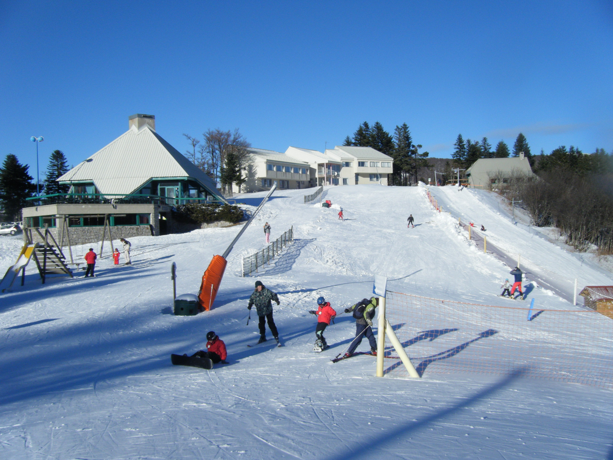
La Croix de Bauzon is a downhill ski area in Ardèche, France. Mapped terrain includes beginner, easy routes. Its mapped lift network extends from approximately 1259 to 1507 metres above sea level. Cross-country skiing is also mapped within the area.
Data: OpenSkiData / OpenSkiMap, OpenStreetMap contributors (ODbL), Skimap.org, Who's On First, Mapterhorn.
La Croix de Bauzon - Base lift station
ECMWF · Model run: Next update expected:
Day Time (UTC) Temp. (°C) Humidity (%) Wind (km/h) Wind (knots) Wind (Bft) Direction Precip. (mm) Snow (cm) Pressure (hPa) Freezing (m) Conditions | Thursday, 05/11 06:00 4.2 99 28 15 4B SE — — 1021 2100 Overcast 97% cloud 09:00 5.1 97 28 15 4B SE 3.8 0 1022 2214 Overcast 99% cloud 12:00 5.6 96 30 16 5B SE 3.4 0 1022 2275 Overcast 99% cloud 15:00 5.6 96 28 15 4B S 4.2 0 1021 2305 Overcast 96% cloud 18:00 5.1 98 22 12 4B S 2.6 0 1022 2226 Overcast 99% cloud 21:00 4.9 98 14 8 3B SE 2.0 0 1023 2197 Overcast 99% cloud Friday, 06/11 00:00 4.5 99 8 4 2B S 3.0 0 1023 2113 Overcast 100% cloud 03:00 4.3 94 5 2 1B SW 3.0 0 1022 2134 Cloudy 74% cloud 06:00 3.5 93 6 3 2B NW 0 0 1022 2083 Cloudy 73% cloud 09:00 4.7 87 10 5 2B N 0 0 1023 2066 Overcast 91% cloud 12:00 6 77 8 4 2B NW 0.02 0 1022 2067 Overcast 84% cloud 15:00 6.1 73 11 6 2B NW 0.04 0 1021 2149 Partly cloudy 22% cloud 18:00 3.8 82 13 7 3B NW 0.02 0 1023 2134 Clear 10% cloud 21:00 3 80 13 7 3B N 0 0 1024 2113 Partly cloudy 40% cloud Saturday, 07/11 00:00 3.2 75 9 5 2B N 0 0 1024 2148 Cloudy 63% cloud 03:00 2.8 72 7 4 2B NW 0 0 1024 2134 Cloudy 52% cloud 06:00 2.7 65 9 5 2B N 0 0 1024 2220 Partly cloudy 29% cloud 09:00 4.5 61 4 2 1B NE 0 0 1024 2278 Partly cloudy 23% cloud 12:00 6.6 56 2 1 1B S 0 0 1022 2382 Cloudy 63% cloud 15:00 6.3 67 3 1 1B SE 0 0 1022 2433 Overcast 93% cloud 18:00 4.4 79 3 2 1B S 0 0 1024 2448 Overcast 92% cloud 21:00 3.8 70 12 6 2B S 0 0 1025 2455 Partly cloudy 36% cloud Sunday, 08/11 00:00 3.3 60 17 9 3B S 0 0 1025 2460 Partly cloudy 30% cloud 03:00 3.1 84 18 10 3B S 0 0 1024 2413 Cloudy 58% cloud 06:00 3.9 95 22 12 4B S 0.02 0 1024 2314 Overcast 100% cloud 09:00 4.8 97 23 13 4B S 0.19 0 1025 2499 Overcast 100% cloud 12:00 5.2 98 29 15 4B S 1.1 0 1024 2449 Overcast 100% cloud 15:00 5.5 99 31 17 5B S 1.3 0 1023 2551 Overcast 100% cloud 18:00 5.8 99 31 17 5B S 1.6 0 1023 2889 Overcast 100% cloud 21:00 6.1 99 34 19 5B S 1.9 0 1023 3104 Overcast 100% cloud Monday, 09/11 00:00 6.2 98 36 20 5B S 1.9 0 1022 3100 Overcast 100% cloud 03:00 6.2 98 40 22 6B S 2.3 0 1021 3090 Overcast 100% cloud 06:00 6.3 98 42 23 6B S 2.7 0 1020 3088 Overcast 100% cloud 09:00 6.5 98 44 24 6B S 3.2 0 1021 3091 Overcast 100% cloud 12:00 6.8 98 44 24 6B S 3.7 0 1020 3068 Overcast 100% cloud 15:00 7.3 99 43 23 6B S 4.6 0 1018 3075 Overcast 100% cloud 18:00 7.5 98 41 22 6B S 4.0 0 1017 3076 Overcast 100% cloud 21:00 7.7 98 40 21 6B S 4.2 0 1017 3073 Overcast 100% cloud Tuesday, 10/11 00:00 7.6 98 37 20 5B S 5.2 0 1016 3070 Overcast 100% cloud 03:00 7.6 98 35 19 5B S 3.6 0 1014 3058 Overcast 100% cloud 06:00 8.2 98 29 15 4B S 1.0 0 1014 3057 Overcast 100% cloud 09:00 9.2 98 21 11 4B S 0.78 0 1014 3061 Overcast 100% cloud 12:00 9.6 97 14 8 3B S 0.67 0 1013 3057 Overcast 99% cloud 15:00 10 96 9 5 2B S 0.20 0 1012 3048 Overcast 98% cloud 18:00 9.4 94 6 3 1B SW 0.04 0 1012 3032 Overcast 90% cloud 21:00 9.4 96 13 7 3B S 0.16 0 1013 2951 Overcast 100% cloud Wednesday, 11/11 00:00 9.5 91 15 8 3B S 0.05 0 1013 3013 Overcast 100% cloud 03:00 9.4 85 13 7 3B S 0.04 0 1012 3042 Overcast 100% cloud 06:00 9 91 16 9 3B S 0.05 0 1012 3045 Overcast 100% cloud |
|---|
Forecast notes
Forecast table times: UTC.
Coordinates: 44.6299169°N, 4.0947728°E · Requested elevation: 1259 m. Model terrain: 883 m. Terrain and 1000/925/850/700 hPa profiles are used for height estimates.
These are altitude estimates, not a simulation of local mountain terrain. Precipitation, cloud and sea-level pressure use horizontal interpolation only.
Precipitation includes rain and snow water equivalent: preceding 3 hours through day 6, then 6 hours (see cell tooltip). Snow (cm) estimates fresh snowfall from precipitation and temperature using the GFS conversion; it is not snow depth on the ground. Freezing (m) uses additional 600/500 hPa temperatures when available and estimates the lowest resolved 0°C crossing above sea level. When all sampled levels are warm, the upper profile limit is shown (see tooltip). < marks an entirely cold sampled profile and its lower height limit. No extrapolation is used.
Source: ECMWF · CC BY 4.0 · Processed by Snow Report.
La Croix de Bauzon - Top lift station
ECMWF · Model run: Next update expected:
Day Time (UTC) Temp. (°C) Humidity (%) Wind (km/h) Wind (knots) Wind (Bft) Direction Precip. (mm) Snow (cm) Pressure (hPa) Freezing (m) Conditions | Thursday, 05/11 06:00 3.4 99 44 24 6B SE — — 1021 2100 Overcast 97% cloud 09:00 3.8 97 43 23 6B SE 3.6 0 1022 2210 Overcast 99% cloud 12:00 4.1 94 47 25 6B SE 3.2 0 1022 2275 Overcast 99% cloud 15:00 4.1 96 43 23 6B S 4.1 0 1021 2303 Overcast 96% cloud 18:00 4.1 98 34 18 5B S 2.7 0 1022 2224 Overcast 99% cloud 21:00 3.9 98 23 13 4B SE 2.1 0 1023 2195 Overcast 100% cloud Friday, 06/11 00:00 3.2 100 14 8 3B S 3.1 0 1023 2113 Overcast 100% cloud 03:00 3.4 92 8 4 2B SW 2.9 0 1022 2136 Cloudy 70% cloud 06:00 3.1 89 8 4 2B NW 0 0 1022 2082 Cloudy 73% cloud 09:00 3.2 81 13 7 3B N 0 0 1023 2068 Overcast 90% cloud 12:00 3.5 84 11 6 2B NW 0.02 0 1022 2068 Overcast 81% cloud 15:00 4 76 16 9 3B NW 0.04 0 1021 2155 Partly cloudy 22% cloud 18:00 3.3 77 18 10 3B NW 0.02 0 1023 2140 Clear 9% cloud 21:00 3 71 17 9 3B N 0 0 1024 2114 Partly cloudy 39% cloud Saturday, 07/11 00:00 2.9 62 11 6 2B N 0 0 1024 2150 Cloudy 65% cloud 03:00 2.8 58 8 4 2B N 0 0 1024 2139 Cloudy 54% cloud 06:00 3.1 50 11 6 2B N 0 0 1024 2225 Partly cloudy 31% cloud 09:00 3.1 53 5 3 1B NE 0 0 1024 2285 Partly cloudy 25% cloud 12:00 4.1 58 3 1 1B SW 0 0 1022 2387 Cloudy 61% cloud 15:00 4.4 69 2 1 1B S 0 0 1022 2436 Overcast 93% cloud 18:00 4 72 4 2 1B S 0 0 1024 2450 Overcast 93% cloud 21:00 3.7 56 17 9 3B S 0 0 1025 2457 Partly cloudy 37% cloud Sunday, 08/11 00:00 3.9 40 26 14 4B S 0 0 1025 2461 Partly cloudy 31% cloud 03:00 3.4 78 27 15 4B S 0 0 1024 2413 Cloudy 61% cloud 06:00 3.4 98 34 18 5B S 0.02 0 1024 2316 Overcast 100% cloud 09:00 3.8 98 34 18 5B S 0.21 0 1025 2504 Overcast 100% cloud 12:00 3.9 99 42 22 6B S 1.1 0 1024 2452 Overcast 100% cloud 15:00 4.3 99 46 25 6B S 1.3 0 1023 2554 Overcast 100% cloud 18:00 4.9 99 46 25 6B S 1.6 0 1023 2899 Overcast 100% cloud 21:00 5.2 99 50 27 6B S 2.0 0 1023 3104 Overcast 100% cloud Monday, 09/11 00:00 5.5 98 53 29 7B S 1.9 0 1022 3100 Overcast 100% cloud 03:00 5.6 99 60 32 7B S 2.3 0 1021 3090 Overcast 100% cloud 06:00 5.6 99 62 34 8B S 2.8 0 1020 3088 Overcast 100% cloud 09:00 5.7 97 65 35 8B S 3.2 0 1021 3091 Overcast 100% cloud 12:00 5.9 98 63 34 8B S 3.7 0 1020 3072 Overcast 100% cloud 15:00 6.4 98 61 33 7B S 4.6 0 1018 3075 Overcast 100% cloud 18:00 6.7 98 57 31 7B S 4.2 0 1017 3076 Overcast 100% cloud 21:00 6.9 98 55 30 7B S 4.4 0 1017 3073 Overcast 100% cloud Tuesday, 10/11 00:00 6.8 97 52 28 7B S 5.3 0 1016 3070 Overcast 100% cloud 03:00 6.7 99 48 26 6B S 3.4 0 1014 3058 Overcast 100% cloud 06:00 7.7 97 40 21 6B S 1.0 0 1014 3057 Overcast 100% cloud 09:00 8.4 97 29 16 4B S 0.79 0 1014 3061 Overcast 100% cloud 12:00 8.3 99 19 10 3B S 0.71 0 1013 3057 Overcast 99% cloud 15:00 8.7 96 12 7 3B S 0.21 0 1012 3048 Overcast 98% cloud 18:00 8.8 92 8 4 2B SW 0.04 0 1012 3032 Overcast 90% cloud 21:00 8.6 95 17 9 3B S 0.17 0 1013 2950 Overcast 100% cloud Wednesday, 11/11 00:00 8.7 86 20 11 3B S 0.04 0 1013 3013 Overcast 100% cloud 03:00 8.7 77 17 9 3B S 0.04 0 1012 3043 Overcast 100% cloud 06:00 8.2 88 21 11 4B S 0.04 0 1012 3045 Overcast 100% cloud |
|---|
Forecast notes
Forecast table times: UTC.
Coordinates: 44.6196874°N, 4.0798489°E · Requested elevation: 1507 m. Model terrain: 886 m. Terrain and 1000/925/850/700 hPa profiles are used for height estimates.
These are altitude estimates, not a simulation of local mountain terrain. Precipitation, cloud and sea-level pressure use horizontal interpolation only.
Precipitation includes rain and snow water equivalent: preceding 3 hours through day 6, then 6 hours (see cell tooltip). Snow (cm) estimates fresh snowfall from precipitation and temperature using the GFS conversion; it is not snow depth on the ground. Freezing (m) uses additional 600/500 hPa temperatures when available and estimates the lowest resolved 0°C crossing above sea level. When all sampled levels are warm, the upper profile limit is shown (see tooltip). < marks an entirely cold sampled profile and its lower height limit. No extrapolation is used.