Worldwide Ski Resort Forecasts

More
Colour guide Temperature · Wind · Rain · Snow
Each colour starts at the value shown. Wind colours match across all three units. Dry cells stay neutral. Colours describe the displayed values, not official weather warnings.
Preparing forecast graphs…
Times and values match the detailed forecast. Tap or point at a value for details. Scroll each chart sideways for later days. Rain / precipitation is the total water equivalent per forecast interval, including snow; snowfall is fresh snow per interval, not snow depth.
GFS and ECMWF model comparison. Each model retains its own forecast times and horizon. Precipitation and snowfall amounts cover their own forecast intervals; these can differ between models.
Forecast values and model notes
Grindelwald-Wengen and the Jungfrau - base
GFS · Model run: · Updated on this site: · 4 model runs daily.Next update expected:
Day Local time Temp. (°C) Humidity (%) Wind (km/h) Wind (knots) Wind (Bft) Direction Rain (mm) Snow (cm) Pressure (hPa) Freezing (m) Conditions | Thursday, 05/11 06 7.4 87 14 8 3B SE 0 0 1025 2208 Clear  09 11.6 76 11 6 2B SE 0 0 1024 2478 Clear 12 14.2 69 6 4 2B SE 0 0 1022 2568 Clear 15 12.3 82 8 4 2B SE 0 0 1022 2541 Clear 18 10 88 12 6 2B SE 0.01 0 1023 2513 Clear 21 10.2 87 10 5 2B SE 0.02 0 1024 2502 Clear Friday, 06/11 00 10.8 87 6 3 2B SE 0.44 0 1022 2416 Light rain  03 10.5 92 5 3 1B S 0.78 0 1022 2269 Light rain 06 9.9 97 3 2 1B SE 1.6 0 1022 2129 Light rain 09 10.3 97 1 1 0B S 0.54 0 1022 2144 Light rain 12 10.4 98 1 1 1B NW 0.95 0 1022 2140 Light rain 15 10 99 3 2 1B NW 1.7 0 1021 2068 Light rain 18 9.1 99 2 1 1B NW 2.9 0 1022 1945 Light rain 21 8.7 99 2 1 1B NW 2.6 0 1023 1894 Light rain Saturday, 07/11 00 8.3 99 4 2 1B NW 2.2 0 1024 1819 Light rain 03 7.7 99 5 3 1B NW 1.5 0 1024 1729 Light rain 06 7.4 98 5 3 1B NW 0.77 0 1025 1676 Light rain 09 8.1 90 1 1 1B S 0.07 0 1024 1755 Chance of rain  12 9.5 88 2 1 1B W 0.06 0 1023 1924 Chance of rain 15 9.3 88 1 1 0B W 0.09 0 1023 1942 Chance of rain 18 5.7 91 8 4 2B SE 0 0 1026 1481 Clear 21 5 89 9 5 2B S 0.01 0 1027 1320 Clear Sunday, 08/11 00 4.7 87 10 5 2B S 0 0 1027 1279 Clear 03 3.8 85 9 5 2B SE 0.01 0 1027 1141 Clear 06 3.5 80 8 4 2B SE 0 0 1027 1100 Clear 09 8.7 73 4 2 1B SE 0.01 0 1024 1830 Clear 12 10.3 69 2 1 1B SW 0.02 0 1023 1975 Clear 15 9.1 84 1 0 0B SW 0.01 0 1023 1916 Clear 18 4.4 87 6 3 2B S 0 0 1027 1384 Clear 21 4.1 77 7 4 2B SE 0 0 1027 1182 Clear Monday, 09/11 00 3.9 74 6 3 2B S 0 0 1026 1159 Clear 03 4 73 5 3 1B SE 0 0 1026 1165 Clear 06 4 72 6 3 2B SE 0 0 1025 1183 Clear 09 10.1 63 4 2 1B S 0 0 1021 2033 Clear 12 11.8 62 2 1 1B SW 0 0 1019 2184 Clear 15 9.6 80 4 2 1B SE 0 0 1020 2064 Clear 18 6.8 72 8 4 2B SE 0 0 1021 1857 Clear 21 6.9 65 9 5 2B SE 0 0 1021 2012 Clear Tuesday, 10/11 00 9.1 65 7 4 2B S 0.05 0 1019 2241 Clear 03 9.1 78 8 4 2B SE 0.39 0 1017 2188 Light rain 06 9.3 90 9 5 2B SE 1.2 0 1016 2308 Light rain 09 10.9 93 9 5 2B S 1.7 0 1014 2543 Light rain 12 12.8 94 8 4 2B SW 2.2 0 1011 2647 Light rain 15 13 95 5 3 1B S 0.60 0 1010 2753 Light rain 18 12.3 97 3 2 1B SW 1.6 0 1010 2686 Light rain 21 12.3 97 3 2 1B SW 2.8 0 1010 2674 Light rain Wednesday, 11/11 00 12.1 97 3 2 1B SW 2.7 0 1010 2632 Light rain 03 12.3 97 2 1 1B SW 1.6 0 1009 2652 Light rain 06 12.3 97 3 1 1B SW 1.2 0 1009 2655 Light rain 09 12.8 97 1 1 0B SW 0.33 0 1010 2687 Light rain 12 13.7 96 4 2 1B W 0.05 0 1009 2697 Chance of rain 15 13 98 3 1 1B W 0.10 0 1009 2686 Chance of rain 18 12 93 2 1 1B SE 0.01 0 1010 2606 Clear 21 11.9 90 2 1 1B S 0 0 1010 2596 Clear Thursday, 12/11 00 11.6 89 2 1 1B S 0 0 1010 2527 Clear 03 11.5 91 2 1 1B S 0.06 0 1009 2475 Chance of rain 06 10.7 91 2 1 1B SE 0.02 0 1009 2336 Clear 09 12.8 92 1 0 0B S 0.06 0 1009 2514 Chance of rain 12 12.2 100 2 1 1B N 1.6 0 1009 2454 Light rain 15 12 97 4 2 1B NE 3.0 0 1010 2464 Rain 18 11 97 4 2 1B E 1.5 0 1011 2481 Light rain 21 10.4 96 6 3 2B SE 0.17 0 1012 2456 Chance of rain Friday, 13/11 00 10.3 93 8 4 2B SE 0.05 0 1012 2470 Clear 03 9.9 93 9 5 2B SE 0.05 0 1013 2444 Clear 06 9.9 91 9 5 2B SE 0.04 0 1013 2413 Clear 09 12 89 8 5 2B SE 0.04 0 1013 2479 Clear 12 13.2 83 6 3 2B SE 0.01 0 1013 2475 Clear 15 11.8 90 6 3 2B SE 0.09 0 1013 2413 Chance of rain 18 9.5 88 10 5 2B SE 0.01 0 1016 2295 Clear 21 8.9 88 11 6 2B SE 0.04 0 1017 2235 Clear Saturday, 14/11 00 9 87 10 5 2B SE 0 0 1017 2256 Clear 03 7.7 84 7 4 2B SE 0 0 1018 2034 Clear 06 7.3 79 4 2 1B SE 0 0 1018 1954 Clear 09 12.1 72 1 1 1B SW 0 0 1016 2388 Clear 12 13.4 76 4 2 1B NW 0 0 1015 2436 Clear 15 11.6 87 5 3 1B N 0 0 1016 2316 Clear 18 9 90 2 1 1B NW 0 0 1019 2113 Clear 21 7.6 89 1 0 0B NW 0 0 1021 1872 Clear Sunday, 15/11 00 9.5 90 3 2 1B NW 0.04 0 1020 2091 Clear 03 10.1 90 4 2 1B NW 0 0 1019 2159 Clear 06 9.8 93 5 3 1B NW 0.09 0 1020 2129 Chance of rain 09 10.8 82 5 3 1B NW 0.01 0 1020 2102 Clear 12 11.6 81 7 4 2B NW 0.03 0 1020 2171 Clear 15 9.7 89 7 4 2B NW 0 0 1022 2002 Clear 18 7.5 80 5 2 1B W 0 0 1025 1977 Clear 21 8.5 60 5 3 1B W 0 0 1024 2060 Clear Monday, 16/11 00 9.6 71 5 3 1B W 0 0 1023 2213 Clear 03 10.4 78 7 4 2B W 0.04 0 1022 2294 Clear 06 10.3 92 6 3 2B W 0.99 0 1023 2295 Light rain 09 12.1 89 8 4 2B NW 0.07 0 1023 2406 Chance of rain 12 12.8 91 5 3 1B W 0.24 0 1022 2534 Chance of rain 15 12.8 93 6 3 2B NW 0.08 0 1022 2618 Chance of rain 18 11.4 87 4 2 1B W 0 0 1023 2652 Clear 21 11 80 3 2 1B W 0 0 1024 2512 Clear Tuesday, 17/11 00 9.4 79 4 2 1B SW 0 0 1024 2390 Clear 03 9.8 77 4 2 1B SW 0 0 1024 2469 Clear 06 10.2 70 5 3 1B S 0 0 1023 2610 Clear 09 14.2 68 6 3 2B SW 0 0 1022 3293 Clear 12 15.9 71 8 4 2B W 0 0 1021 3277 Clear 15 14.6 79 6 3 2B W 0 0 1022 3049 Clear 18 14.1 80 7 4 2B SW 0.09 0 1023 3166 Chance of rain 21 13.3 79 7 4 2B W 0.02 0 1023 3214 Clear Wednesday, 18/11 00 13.7 82 6 3 2B SW 0.36 0 1024 3079 Light rain 03 14.4 85 6 3 2B W 0.54 0 1022 3162 Light rain 06 14.8 73 7 4 2B W 0.01 0 1022 3406 Clear 09 16.2 74 6 3 2B W 0 0 1022 3621 Clear 12 17.2 74 8 4 2B W 0 0 1021 3791 Clear 15 15.3 76 7 4 2B W 0 0 1022 3784 Clear 18 13.8 55 7 4 2B SW 0 0 1022 3740 Clear 21 13.5 38 8 5 2B SW 0 0 1022 3707 Clear Thursday, 19/11 00 12.3 42 9 5 2B W 0 0 1024 3419 Clear 03 10.6 54 9 5 2B W 0 0 1026 2858 Clear 06 9.5 65 6 3 2B W 0 0 1028 2651 Clear 09 13.5 62 6 3 2B NW 0 0 1027 3224 Clear 12 15.5 63 7 4 2B NW 0 0 1026 3287 Clear 15 12 77 7 4 2B N 0 0 1027 2837 Clear 18 9.8 54 1 0 0B SE 0 0 1028 2743 Clear 21 9.3 39 2 1 1B SW 0 0 1028 2759 Clear Friday, 20/11 00 9.5 30 3 2 1B S 0 0 1027 2801 Clear 03 9.7 28 3 1 1B S 0 0 1026 2808 Clear 06 10.5 28 3 2 1B S 0 0 1025 2830 Clear 09 14.7 39 3 2 1B SW 0 0 1024 3413 Clear 12 16.3 45 6 3 2B W 0 0 1023 3357 Clear 15 12.8 55 6 3 2B W 0 0 1022 3169 Clear 18 11 53 6 3 2B W 0 0 1023 2695 Clear 21 10.8 49 7 4 2B W 0 0 1023 2619 Clear Saturday, 21/11 00 10.5 58 8 4 2B W 0 0 1023 2506 Clear 03 10.9 61 10 5 2B W 0 0 1021 2439 Clear 06 10.2 85 11 6 2B W 0.33 0 1020 2202 Light rain |
|---|
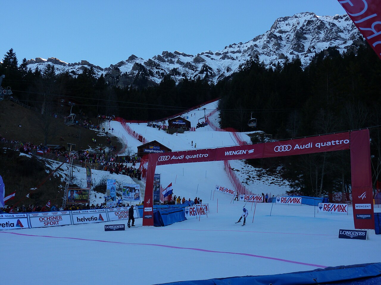
Grindelwald-Wengen covers the Kleine Scheidegg and Männlichen sectors, with the Lauberhorn slopes forming part of its identity. The wider Jungfrau Ski Region also includes Grindelwald-First and Mürren-Schilthorn. These names describe distinct ski areas: a regional pass or a regional piste total should not be read as one uninterrupted ski route.
For orientation, begin with the part of the official map that matches your departure point. A day around Kleine Scheidegg is a different plan from one at First or Mürren. Railways and mountain lifts are part of the area’s transport network, so the return journey deserves the same attention as the first ascent.
The forecast on this page starts at 1,062 m. It is a lower reference for this broad mountain destination, not a prediction for the surrounding summits. Compare weather at your chosen skiing height and at the lower return point. A temperature rise can change the precipitation type between those levels. The public forecast cannot determine the condition or opening of an individual piste; use the regional live report for that detail.
Official sources: Jungfrau Ski Region · Grindelwald-Wengen. Reviewed 18 October 2026.